1849 Perthes / Berghaus Map of the River Systems of the Americas
AmericasRivers-perthes-1849$200.00

Title
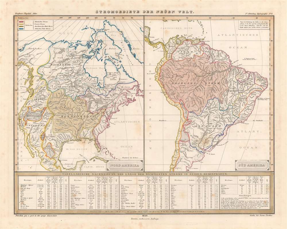
Stromgebiete der Neüen Welt.
1849 (dated) 12.5 x 16.5 in (31.75 x 41.91 cm) 1 : 25000000
1849 (dated) 12.5 x 16.5 in (31.75 x 41.91 cm) 1 : 25000000
Description
This is an attractive hand-colored 1849 map of the major river basins in North and South America made for Berghaus' Physikalischer Atlas, a landmark achievement in German cartography, published by Justus Perthes. As with the atlas as a whole, it shows great attention to detail and the concise presentation of scientific data.
Golden Age of Canalas
A note at top-right points out that, as with the previous map in the series on Hydrography ('Asia-Europa; in Beziehung auf das Fliessende, und seine Vertheilung in Stromgebiete'), canals are marked by a thick black line. This map dates from the 'golden age' of canal building in the United States, after the success of the Erie Canal (opened 1825) but before railroads became a widespread, faster alternative (even though many railroads were initially built to supplement rather than replace canals). Several canal systems of the northeastern United States are indicated, including the Ohio Canal, Erie Canal (here as 'Gr. Canal,' presumably Große), the Connecticut Canal (also known as the Farmington Canal, the New Haven and Northampton Canal, and the Hampshire and Hampden Canal), and the Champlain Canal, indicated by a line but not named. Some of the canal lines shown here are fictious, such as a cluster near the Florida Panhandle, likely the result of limited or inaccurate information reaching Berghaus.A Closer Look
At top-left, a legend denotes colors used to show which rivers flow into which oceans and seas. A table at bottom lists the lengths of the world's major rivers. The numbers written within the various river basin areas on the map are most likely the area of those river basins, in German miles. It is worth pointing out that German miles were more than four times longer than English miles (24,000 German feet versus 5,000 English feet).Publication History and Census
This map was included in the 2nd Division (Abtheilung), No. 8 'Hydrology' of Berghaus' Physikalischer Atlas, published by Justus Perthes. It was drawn at the Geographische Kunstschule in Potsdam (which Berghaus had founded) and published in Gotha. Berghaus' Physikalischer Atlas was initially published as an addendum to Alexander von Humboldt's extremely popular and influential book Kosmos, which incidentally was strongly influenced by his travels in the Americas. With the publicity attracted by its association with Humboldt, Berghaus' atlas quickly became well-known and regarded as a triumph in its thorough research, coverage of a wide range of subjects, and clever methods for presenting data. This map is only cataloged as belonging to the holdings of a small handful of libraries in Germany and it is scarce to the market.CartographerS
Johan Georg Justus Perthes (September 11, 1749 - May 2, 1816) was one of the most important German cartographic engravers of the 19th century. He was born in the Thuringian town of Rudolstadt, the son of a court physician. In 1778, he began working as a bookseller in Gotha. Perthes began his publishing empire shortly thereafter with the 1784 issue of the famed survey of European nobility known as the Almanac de Gotha. In the next year, 1785, he founded the cartographic firm of Justus Perthes Geographische Anstalt Gotha. His son Wilhelm Perthes (1793 - 1853) joined the firm in 1814. Wilhelm had prior publishing experience at the firm of Justus Perthes' nephew, Friedrich Christoph Perthes, who ran a publishing house in Hamburg. After Justus Perthes died in 1816, Wilhelm took charge and laid the groundwork for the firm to become a cartographic publishing titan. From 1817 to 1890. the Perthes firm issued thousands of maps and more than 20 different atlases. Along with the visionary editors Hermann Berghaus (1797 - 1884), Adolph Stieler (1775 - 1836), and Karl Spruner (1803 - 1892), the Perthes firm pioneered the Hand Atlas. When Wilhelm retired, management of the firm passed to his son, Bernhardt Wilhelm Perthes (1821 – 1857). Bernhardt brought on the cartographic geniuses August Heinrich Peterman (1822 - 1878) and Bruno Hassenstein (1839 - 1902). The firm was subsequently passed to a fourth generation in the form of Berhanrd Perthes (1858 – 1919), Bernhard Wilhelm's son. The firm continued in the family until 1953 when, being in East Germany, it was nationalized and run as a state-owned enterprise as VEB Hermann Haack Geographisch-Kartographische Anstalt Gotha. The Justus family, led by Joachim Justus Perthes and his son Wolf-Jürgen Perthes, relocated to Darmstadt where they founded the Justus Perthes Geographische Verlagsanstalt Darmstadt. More by this mapmaker...
Heinrich Karl Wilhelm Berghaus (May 3, 1797 – February 17, 1884) was a German (Prussian) geographer who founded the Geographische Kunstschule in Potsdam and trained several important German geographers and cartographers of the late 19th century, including August Heinrich Petermann and his nephew Hermann Berghaus. The elder Berghaus also was a friend and associate of Alexander von Humboldt, producing some of the maps in his publications. In 1837, he inherited the Daniel Gottlob Reymann (1759 – 1837) monumental Geographischer Specialatlas von Deutschland. Berghaus is best known for his own influential and wide-ranging atlases, namely Atlas von Asien, published between 1833 and 1837, and Berghaus' Physikalischer Atlas, published in multiple editions in the 1830s - 1840s. Although Atlas von Asien was a commercial failure, it was regarded as a work of supreme quality, boosting the reputation of the publisher Justus Perthes and setting up their next collaboration, Berghaus' Physikalischer Atlas, for success. Learn More...
Source
Berghaus, H., Berghaus' Physikalischer Atlas (Gotha: J. Perthes) 1847.
Condition
Good. Some foxing, especially in margins.
References
Rumsey 2515.019. OCLC 1262656781, 165436695.