This item has been sold, but you can get on the Waitlist to be notified if another example becomes available, or purchase a digital scan.
1803 Ottoman-Turkish Raif Efendi Map of America
Amerika-efendi-1803$6,250.00

Title
Amerika.
1803 (undated) 20.25 x 23.75 in (51.435 x 60.325 cm) 1 : 6350000
1803 (undated) 20.25 x 23.75 in (51.435 x 60.325 cm) 1 : 6350000
Description
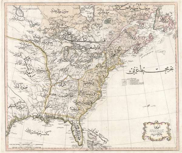
An extraordinary discovery of the utmost importance and rarity, this is Rāif Maḥmūd Efendi's 1803 Ottoman-Turkish map of the United States. The map covers the eastern part of North America from the mouth of the Rio Bravo (Texas) to Newfoundland and from Hudson Bay to the Florida Keys Cartographically, Efendi's map follows closely on William Faden's 1796 map of the United States with a few noteworthy exceptions. While Faden correctly names the United States, Efendi employs the term Cumhurunun Ülkesi or, in translation 'Republic of the English People.' The map is geographically very similar to Faden, but is less detailed in general, with fewer place names identified, the emphasis being instead on beautiful and richly flourishing Arabic script. The United States, Spanish and British territory are distinguished, as in Faden's map, by color coding, although the borders are less specific, suggesting a lack of familiarity not only with America, but with New World political issues in general.
This map, and the atlas that contained it, the Cedīd Aṭlas Tercümesi, was issued under the patronage of Sultan Selim III (1789-1807). Selim III was progressively minded and instated the Nizam-i Cedid, or 'New Order,' an attempt to modernize the Ottoman Empire's educational, military, and administration systems by adopting western social and technological advancements.
This map was published as plate no. 22 in Efendi's Cedīd Aṭlas Tercümesi, considered the first atlas printed in the Ottoman Empire. This atlas is extremely rare and the individual maps equally so. Only 50 copies of the Cedīd Aṭlas Tercümesi were printed. Of these several were given to important figures and Ottoman institutions, some of which may still retain their copies. While the remainder were set aside for private sale, those not quickly sold were tragically lost in an 1808 fire associated with the Janissary Revolt in which both Efendi and the progressive Sultan who sponsored the atlas, Selim III, lost their lives. A once in a lifetime collecting opportunity.
Cartographer
Rāif Maḥmūd Efendi (c. 1760 – 1807) was an ottoman diplomat, scholar, painter and author active in the late 18th and early 19th century. From 1793- 1797 Efendi was First Secretary to the first permanent Ottoman Ambassador to London, Yusuf Agah Efendi. While in England her acquired the nickname 'British Mahmoud.' He also began the work that culminated in the publication of the Cedīd Aṭlas Tercümesi, the first printed Ottoman world atlas. Efendi was a supporter of the progressive Sultan Selim III, whose instated Nizam-i Cedid, or 'New Order,' was aggressively attempting to modernize the Ottoman Empire. The Janissaries, a powerful Turkish-Christian military order, rebelled against the changes, ultimately slaying Selim III and Effendi. Although Effendi's precise birthdate is unknown, he is believed to have been about 47 at the time of his death. More by this mapmaker...
Source
Effendi, Rāif Maḥmūd, Cedīd Aṭlas Tercümesi (Üsküdar: Ottoman Military Engineering School Printing Press) 1803.
Condition
Very good. Slight wear on original centerfold. Else fine.
References
OCLC 777210997. University of Southern Maine, Osher map Library, 14470.0001.