This item has been sold, but you can get on the Waitlist to be notified if another example becomes available, or purchase a digital scan.
1780 Raynal and Bonne Map of North America
Amerique-bonne-1780$150.00

Title
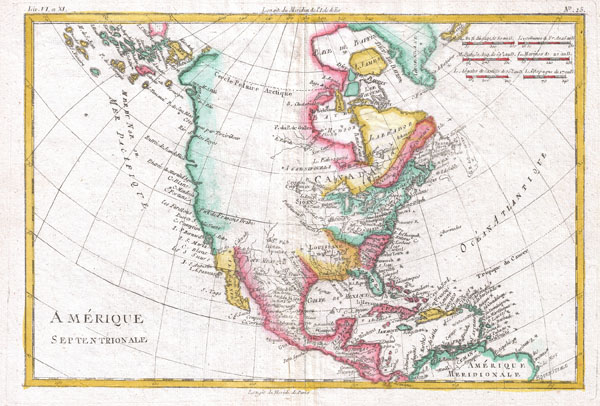
Amerique Septentrionale.
1780 (undated) 9 x 13 in (22.86 x 33.02 cm)
1780 (undated) 9 x 13 in (22.86 x 33.02 cm)
Description
A fine example of Rigobert Bonne and Guilleme Raynal's 1780 map of North America. Covers the entire continent from the high arctic to Central America, the Caribbean, and the Spanish Main. Offers an early perspective on the region including the identification of Louisiana, Virginia, Florida, and New England. The representation of the western coast of the continent is exceptionally primitive and corresponds to the pre-Cook conception of the territory. San Francisco Bay is nowhere in evidence unless it is interpreted as the 'Port of Francois Drake,' where Drake sheltered and repaired his ships in 1579 - the exact location of which remains a mystery to this day. Alaska itself is not clearly present, but a vague mapping of an archipelago in the extreme northwest is suggestive of the Aleutian Islands. Bonne does note the entradas of Martin d'Aguiler and Jean de Fuca as well as certain lands that he suggests are the coasts seen by the Russian Arctic explorer Tszirikow, though this too is no doubt a misinterpretation of the Aleutian Archipelago. Bonne makes no suggestion of a northwest passage. In fact, he closes Baffin Bay and attaches it to Greenland. However, Bonne does leave open certain entradas, most specifically that of Jean De Fuca, suggesting a possible river route. That said, much of the western part of the continent was entirely unexplored and, not one to presume, Bonne chose to leave it blank. Certain American Indian nations, including the Sioux, Assenipoules, and the Apache are noted. All in all, this is a wonderful small map of North America just prior to the significant exploratory efforts of the late 18th and early 19th century. Drawn by R. Bonne for G. Raynal's Atlas de Toutes les Parties Connues du Globe Terrestre, Dressé pour l'Histoire Philosophique et Politique des Établissemens et du Commerce des Européens dans les Deux Indes.
CartographerS
Rigobert Bonne (October 6, 1727 - September 2, 1794) was one of the most important French cartographers of the late 18th century. Bonne was born in Ardennes à Raucourt, France. He taught himself mathematics and by eighteen was a working engineer. During the War of the Austrian Succession (1740 - 1748) he served as a military engineer at Berg-op-Zoom. It the subsequent years Bonne became one of the most respected masters of mathematics, physics, and geography in Paris. In 1773, Bonne succeeded Jacques-Nicolas Bellin as Royal Cartographer to France in the office of the Hydrographer at the Depôt de la Marine. Working in his official capacity, Bonne compiled some of the most detailed and accurate maps of the period - most on an equal-area projection known erroneously as the 'Bonne Projection.' Bonne's work represents an important step in the evolution of the cartographic ideology away from the decorative work of the 17th and early 18th century towards a more scientific and practical aesthetic. While mostly focusing on coastal regions, the work of Bonne is highly regarded for its detail, historical importance, and overall aesthetic appeal. Bonne died of edema in 1794, but his son Charles-Marie Rigobert Bonne continued to publish his work well after his death. More by this mapmaker...
Guillaume Thomas Raynal (April 12, 1711 - March 6, 1796) was a French writer, philosopher, and historian active during the Enlightenment. Raynal was educated as a Jesuit, but left the order for unknown reasons, and moved to Paris where he dedicated himself to the production of a number of minor but popular historical works. Raynal's histories opened doors to elite social and artistic circles where he met and befriended various members of the Philosophe Coteries. Raynal's most important work is generally considered to be a 1770 collaboration with Diderot and others entitled, L'Histoire philosophique et politique des établissements et du commerce des Européens dans les deux Indes. Some of the philosophical ideas developed in the book drew negative attention from the authorities who banned the book and posted a notice for the arrest of its authors. Raynal fled to Berlin and later to St. Petersburg, where he lived for a number of years before returning to France in 1787. Though not a cartographer Raynal's name is often attached to several Atlases by Rigobert Bonne, from whom he composed the text. Learn More...
Source
Raynal, G., Atlas de Toutes les Parties Connues du Globe Terrestre, Dressé pour l'Histoire Philosophique et Politique des Établissemens et du Commerce des Européens dans les Deux Indes, 1780.
Condition
Very good. Original centerfold. Platemark visible. Blank on verso.