This item has been sold, but you can get on the Waitlist to be notified if another example becomes available, or purchase a digital scan.
1760 Desnos and De La Tour Map of North America and South America
Amerique-desnos-1760$250.00

Title
Amerique.
c. 1760 (undated) 14.5 x 21 in (36.83 x 53.34 cm)
c. 1760 (undated) 14.5 x 21 in (36.83 x 53.34 cm)
Description
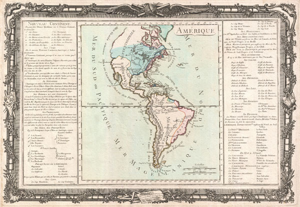
This is an extremely rare example of Desnos and Brion de la Tour's c. 1760 mapping of America. Covers both North America and South America from Greenland to Cape Horn. Overall the general form of the continents exhibit an craggy and exceptionally rugged coast line - a step back from some more advanced maps of this region available at the time.
The cartography of North America, particularly the pre-Cook northwest is speculative and indistinct. The cartographer hints at a Northwest Passage via the lake and river systems extending westward from the St. Lawrence, through the Great Lakes, to Lake Winnipeg and the Lake of the Woods. Though the westwards passage is incomplete, a suggestive open inlet does appear just north of Cape Mendocino. This variant on the Northwest Passage was the great unrealized hope of the French Empire in North America, who unlike the Spanish to the south, had no easy access to the trade riches of the Pacific.
Identifies the English colonies along the East Coast, in Newfoundland, and around the Hudson Bay. Spanish holdings in Mexico and Florida are also noted. Here the cartographer, a Frenchman, has exaggerated the extent of French Louisiana. A clear case of carto-advocacy and pandering to a constituency.
In South America the interior is even more vaguely mapped than in North America. The Orinoco, Amazon and La Plata river systems penetrate deeply into the continent, but exhibit none of the vast network of tributaries for which they are best known. The Rio de La Plata terminates at the Lac Xarayes, a mythical lake often associated with legends of the Earthly Paradise and El Dorado, but in fact simply a misinterpretation of the Pantanal during its annual inundation.
To the left and right of the map are statistical tables and French language descriptions of the continents. Surrounding the whole is an elaborate decorative border featuring floral arrangements, surveying tools, elaborate baroque scalloping, and a winged globe. This example comes from an exceptionally rare side bound edition of this atlas, consequently there is no centerfold.
CartographerS
Louis Brion de la Tour (1743 - 1803) was the Cartographer Royal to the King of France, his official title being Ingenieur-Geographe du Roi. Despite a prolific cartographic career and several important atlases to his name, little is actually known of his life and career. He may have been born in Bordeaux. His son of the same name was born in 1763 and published until his death in 1832. It is nearly impossible to distinguish the work of the father from the work of the son, as both used the same imprint and were active in roughly the same period. Much of their work was published in partnership Louis Charles Desnos (fl. 1750 - 1790). Their most notable work is generally regarded to be his 1766 Atlas General. More by this mapmaker...
Louis Charles Desnos (1725 - April 18, 1805) was an important 18th century instrument maker, cartographer and globe maker based in Paris, France. Desnos was born in Pont-Sainte-Maxence, Oise, France, the son of a cloth merchant. From April of 1745 he apprenticed at a metal foundry. Desnos married the widow of Nicolas Hardy, sone of the map, globe, and instrument seller Jacques Hardy. Desnos held the coveted position of Royal Globemaker to the King of Denmark, Christian VII, for which he received a stipend of 500 Livres annually. In return Desnos sent the King roughly 200 Livres worth of maps, books and atlases each year. As a publisher, Desnos produced a substantial corpus of work and is often associated with Zannoni and Louis Brion de la Tour (1756-1823). Despite or perhaps because of the sheer quantity of maps Desnos published he acquired a poor reputation among serious cartographic experts, who considered him undiscerning and unscrupulous regarding what he would and would not publish. Desnos consequently had a long history of legal battles with other Parisian cartographers and publishers of the period. It is said that he published everything set before him without regard to accuracy, veracity, or copyright law. Desnos maintained offices on Rue St. Jacques, Paris. Learn More...
Condition
Very good. From scarce side bound edition of atlas - so no centerfold! Blank non verso. Original platemarks visible for both map and border.