1782 Jaillot Wall Map of America
Amerique-jaillot-1782$9,000.00
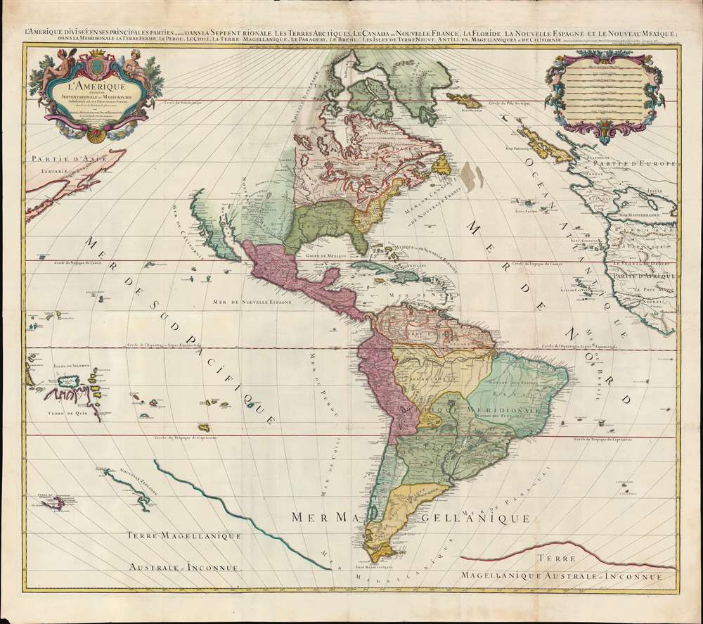

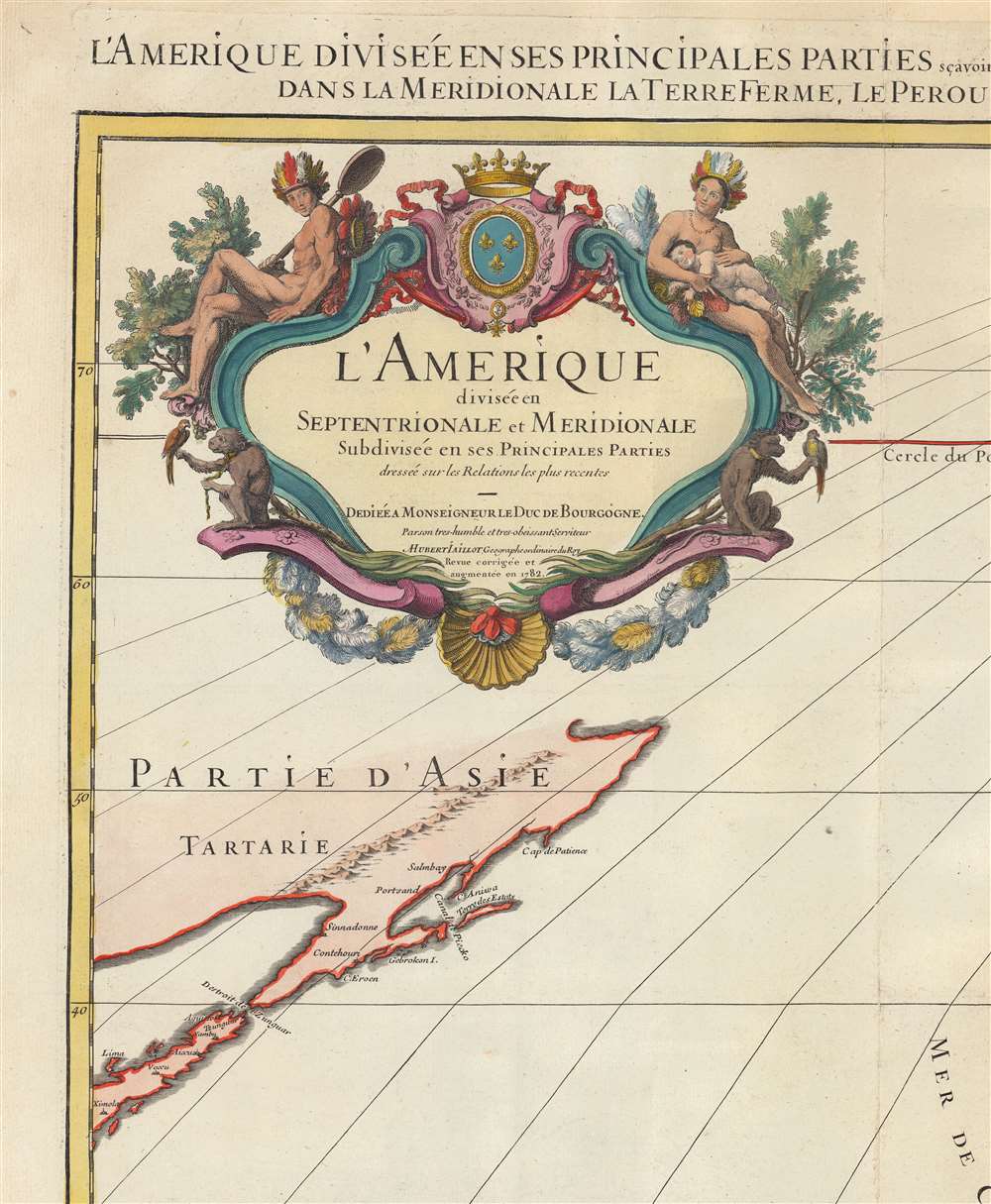


Title
L'Amérique divisée en septentrionale et méridionale subdivisée en ses principales parties. / L'Amérique divisée en ses principales parties sçavoir dans la Septentrionale les Terres Arctiques, le Canada ou Nouvelle France, la Floride, la Nouvelle Espagne et le Nouveau Mexique ; dans la Méridionale la Terre Ferme, le Pérou, le Chili, la Terre Magellanique, le Paraguay, le Brésil. Les isles de Terre Neuve, Antilles, Magellaniques et de Californie.
1782 (dated) 48.75 x 55 in (123.825 x 139.7 cm) 1 : 15000000
1782 (dated) 48.75 x 55 in (123.825 x 139.7 cm) 1 : 15000000
Description
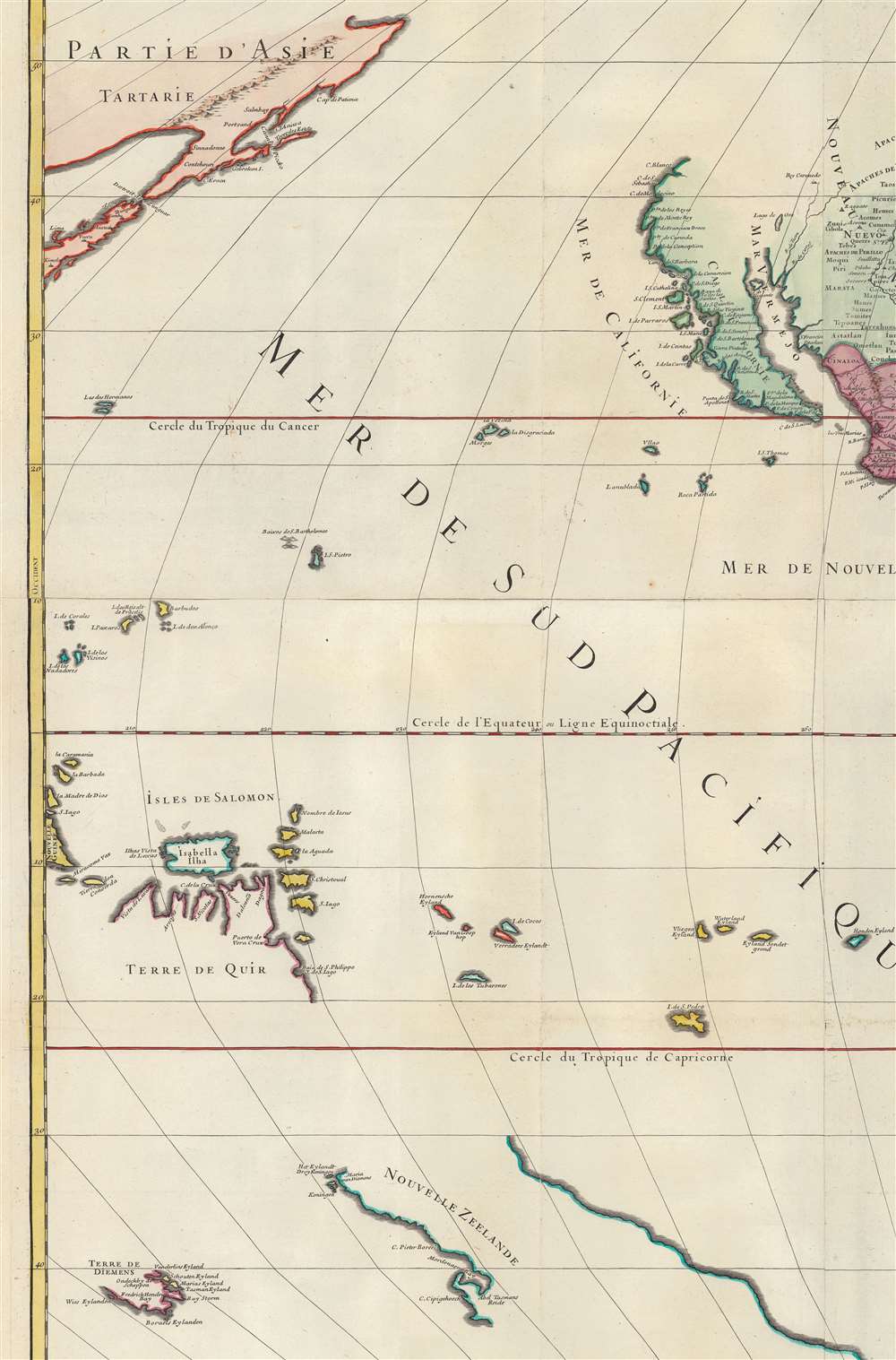
A spectacular 1782 wall map of North America and South America issued at the height of the American Revolutionary War, by Louis Charles Desnos, after Alexis-Hubert Jaillot. The map captures French ambitions to reclaim its American territories in the wake of the American Revolution. It also features the wealth of cartographic speculation of the era, including an unexplored Pacific Northwest and Arctic. The lower quadrants also reveal vestiges of the 16th century Terre Australis - the mythical southern continent disproven by Cook's first two voyages (His third voyage returned in 1880, but information about its discoveries had not yet been disseminated).
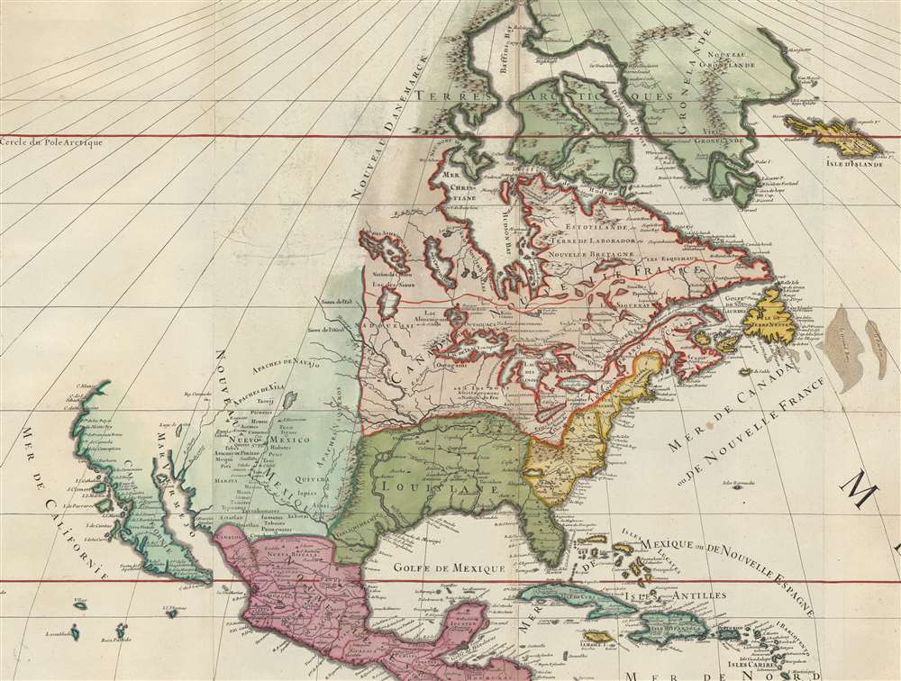
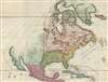
This Mississippi River here finds its outlet far west of its actual location, reflecting the partially fabricated 1696 cartography of Louis Hennepin (1626 - 1704). Hennepin, a Franciscan Recollet missionary and priest, visited the Upper Mississippi with La Salle (1643 - 1687) and later on his own in the 1670s. He published d several works, described an extensive voyage down the Mississippi, toward the Gulf of Mexico. This voyage did occur, but Hennepin never made it to the Gulf of Mexico, and fabricated much of his narrative. It was nonetheless popular with mapmakers, who followed Hennepin's geography on their own maps - as here. Hennepin's major error was hewing too closely to where La Salle believed the mouth of the Mississippi to be located.
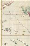
Most interesting is the early mapping of the Solomon Islands (Isles de Salomon) and the apocryphal 'Terre de Quir'. Named after the Portuguese navigator Pedro Fernández de Quirós (1565 - 1615). Quirós initially explored these seas in 1595 on the second Álvaro de Mendaña (1542 - 1595) voyage, but the cartography here represents his independent 1605 voyage with Luiz de Váez de Torres in search of Terre Australis. In May 1606, the expedition reached the islands today known as the New Hebrides or Vanuatu. Quirós landed on a large island he assumed must be the undiscovered but heavily mapped Terre Australis, which he named Australia del Espíritu Santo. Most early maps depicting Terre Australis include a large upward projection roughly in the vicinity of Australia - whether this represents some geographical reasoning or mere speculation is unknown. When Quirós landed on Espíritu Santo, he believed he discovered the northern tip of this promontory. The island is still called Espíritu Santo today, but it is indeed an island, not a continent. Here Quirós hoped to establish a religious colony he called 'Nova Jerusalem'. Shortly thereafter, Quirós' crew mutinied and returned to Mexico. Quirós eventually made his way back to Spain, where he published his voyages and entreated the king, Phillip II, to sponsor another voyage. Unfortunately, by this time, he was widely regarded as a crack and mostly ignored.
North America
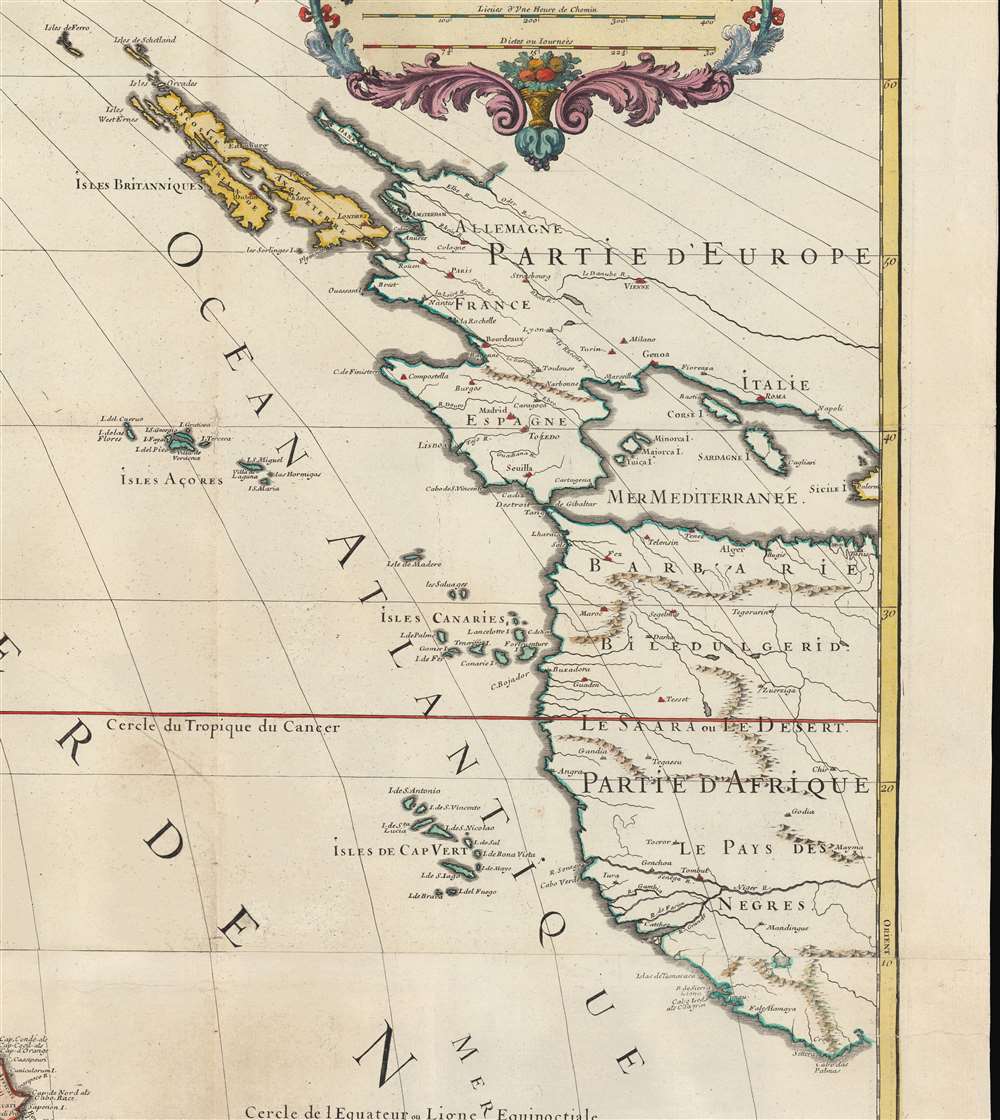
This map was made near the end of the American Revolutionary War (1775 - 1783), but the cartography of North America presented reflets the state of affairs during the French and Indian War (1754 - 1763) - likely underscoring French ambitions to reclaim lost territory in the aftermath of the Revolutionary War. Here, the British colonies in yellow hug the coast and do not extend westward beyond the Appalachian Mountains. French Territory, by contrast, is expansive, and divided according to the 1717 designation separating Nouvelle France, in pink, which includes all of the Great Lakes and Canada; from Lower Louisiana, in green, comprising of the Gulf Coast from the Rio de Palmas to Florida. This map would be updated for its final edition in 1783 to reflect the Treaty of Paris and the results of the American Revolution.This Mississippi River here finds its outlet far west of its actual location, reflecting the partially fabricated 1696 cartography of Louis Hennepin (1626 - 1704). Hennepin, a Franciscan Recollet missionary and priest, visited the Upper Mississippi with La Salle (1643 - 1687) and later on his own in the 1670s. He published d several works, described an extensive voyage down the Mississippi, toward the Gulf of Mexico. This voyage did occur, but Hennepin never made it to the Gulf of Mexico, and fabricated much of his narrative. It was nonetheless popular with mapmakers, who followed Hennepin's geography on their own maps - as here. Hennepin's major error was hewing too closely to where La Salle believed the mouth of the Mississippi to be located.
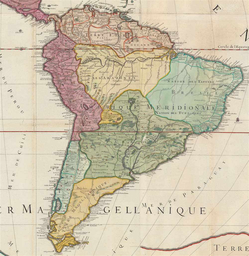
South America
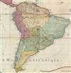
South America is here presented to close adherence to conventions of the period. The coastal colonies and settlements are well mapped, but inland remains vague and speculative. Desnos entirely removes Lake Parima - the supposed site where Sir Walter Raleigh discovered El Dorado in modern-day British Guiana, but maps the city of 'Manoa o el Dorade'. He retains Cassipa L., following closely on the 1656 Sanson model.Laguna de Xarayes
Further south, the mythical Laguna de Xarayes is illustrated here as the northern terminus, or source, of the Paraguay River. The Xarayes, a corruption of 'Xaraies' meaning 'Masters of the River', were an indigenous people occupying what are today parts of Brazil's Matte Grosso and the Pantanal. When Spanish and Portuguese explorers first navigated up the Paraguay River, as always in search of El Dorado, they encountered the vast Pantanal flood plain at the height of its annual inundation. Understandably misinterpreting the flood plain as a gigantic inland sea, they named it after the local inhabitants, the Xaraies. The Laguna de los Xarayes almost immediately began to appear on early maps of the region and, at the same time, to take on a legendary quality. Later missionaries and chroniclers, particularly Díaz de Guzman (1559 - 1629), imagined an island in this lake and curiously identified it as 'Island of Paradise,'...an island [of the Paraguay River] more than ten leagues [56 km] long, two or three [11-16 km] wide. A very mild land rich in a thousand types of wild fruit, among them grapes, pears and olives: the Indians created plantations throughout, and throughout the year sow and reap with no difference in winter or summer, ... the Indians of that island are of good will and are friends to the Spaniards; Orejón they call them, and they have their ears pierced with wheels of wood ... which occupy the entire hole. They live in round houses, not as a village, but each apart though keep up with each other in much peace and friendship. They called of old this island Land of Paradise for its abundance and wonderful qualities.
The Pacific and Terre de Quir
At the far west of the map in the Pacific, we can recognize the Arctic discoveries of the Vitus Bering's Great Northern Expedition (1733 - 1743) Expedition. At the extreme south, we can see partial mappings of New Zealand (Nouvelle Zeelande) and Tasmania (Terre de Diemens), based upon the exploration of Abel Tasman (1603 - 1659). Between them, New Guinea (Nouvelle Guinee) is just recognizable at the edge of the page.Most interesting is the early mapping of the Solomon Islands (Isles de Salomon) and the apocryphal 'Terre de Quir'. Named after the Portuguese navigator Pedro Fernández de Quirós (1565 - 1615). Quirós initially explored these seas in 1595 on the second Álvaro de Mendaña (1542 - 1595) voyage, but the cartography here represents his independent 1605 voyage with Luiz de Váez de Torres in search of Terre Australis. In May 1606, the expedition reached the islands today known as the New Hebrides or Vanuatu. Quirós landed on a large island he assumed must be the undiscovered but heavily mapped Terre Australis, which he named Australia del Espíritu Santo. Most early maps depicting Terre Australis include a large upward projection roughly in the vicinity of Australia - whether this represents some geographical reasoning or mere speculation is unknown. When Quirós landed on Espíritu Santo, he believed he discovered the northern tip of this promontory. The island is still called Espíritu Santo today, but it is indeed an island, not a continent. Here Quirós hoped to establish a religious colony he called 'Nova Jerusalem'. Shortly thereafter, Quirós' crew mutinied and returned to Mexico. Quirós eventually made his way back to Spain, where he published his voyages and entreated the king, Phillip II, to sponsor another voyage. Unfortunately, by this time, he was widely regarded as a crack and mostly ignored.
Terre Magellanique / Terre Australis
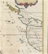
Massing at the base of the map and fully occupying the lower left inset is the speculative southern continent or as here Terre Magellanique Australe et Inconnue. Long before the discovery of Antarctica, the southern continent, supposedly capping the South Pole, was speculated upon by European geographers of the 16th and 17th centuries. It was thought, based upon the writings of Aristotle, that the globe was a place of balance and thus geographers presumed the bulk of Eurasia must be counterbalanced by a similar landmass in the Southern Hemisphere, just as, they argued, the Americas counterbalanced Africa and Europe. Many explorers in the 16th and 17th centuries sought the Great Southern continent, including Quirós, Drake, and Cook, but Antarctica itself was not truly discovered until Edward Bransfield and William Smith sighted the Antarctic Peninsula in 1820.Publication History and Census
This map is rare. We note maybe 5 examples of the 1783 edition in various institutions, but no examples of the 1782. The 1782, as here, was issued by Louis Charles Desnos (1725 - 1805), but the plates were acquired by Louis Brion de la Tour (1743 - 1803), who issued the final edition in 1783. There do appear to be earlier maps as early as 1695 by Sanson / Jaillot that bear a similar title, but it is not clear if they represent earlier editions of fully separate maps as none are well cataloged or imaged.CartographerS
Alexis-Hubert Jaillot (c. 1632 - 1712) followed Nicholas Sanson (1600 - 1667) and his descendants in ushering in the great age of French Cartography in the late 17th and 18th century. The publishing center of the cartographic world gradually transitioned from Amsterdam to Paris following the disastrous inferno that destroyed the preeminent Blaeu firm in 1672. Hubert Jaillot was born in Franche-Comte and trained as a sculptor. When he married the daughter of the Enlumineur de la Reine, Nicholas I Berey (1610 - 1665), he found himself positioned to inherit a lucrative map and print publishing firm. When Nicholas Sanson, the premier French cartographer of the day, died, Jaillot negotiated with his heirs, particularly Guillaume Sanson (1633 - 1703), to republish much of Sanson's work. Though not a cartographer himself, Jaillot's access to the Sanson plates enabled him to publish numerous maps and atlases with only slight modifications and updates to the plates. As a sculptor and an artist, Jaillot's maps were particularly admired for their elaborate and meaningful allegorical cartouches and other decorative elements. Jaillot used his allegorical cartouche work to extol the virtues of the Sun King Louis IV, and his military and political triumphs. These earned him the patronage of the French crown who used his maps in the tutoring of the young Dauphin. In 1686, he was awarded the title of Geographe du Roi, bearing with it significant prestige and the yearly stipend of 600 Livres. Jaillot was one of the last French map makers to acquire this title. Louis XV, after taking the throne, replaced the position with the more prestigious and singular title of Premier Geographe du Roi. Jaillot died in Paris in 1712. His most important work was his 1693 Le Neptune Francois. Jalliot was succeeded by his son, Bernard-Jean-Hyacinthe Jaillot (1673 - 1739), grandson, Bernard-Antoine Jaillot (???? – 1749), and the latter's brother-in-law, Jean Baptiste-Michel Renou de Chauvigné-Jaillot (1710 - 1780). More by this mapmaker...
Louis Charles Desnos (1725 - April 18, 1805) was an important 18th century instrument maker, cartographer and globe maker based in Paris, France. Desnos was born in Pont-Sainte-Maxence, Oise, France, the son of a cloth merchant. From April of 1745 he apprenticed at a metal foundry. Desnos married the widow of Nicolas Hardy, sone of the map, globe, and instrument seller Jacques Hardy. Desnos held the coveted position of Royal Globemaker to the King of Denmark, Christian VII, for which he received a stipend of 500 Livres annually. In return Desnos sent the King roughly 200 Livres worth of maps, books and atlases each year. As a publisher, Desnos produced a substantial corpus of work and is often associated with Zannoni and Louis Brion de la Tour (1756-1823). Despite or perhaps because of the sheer quantity of maps Desnos published he acquired a poor reputation among serious cartographic experts, who considered him undiscerning and unscrupulous regarding what he would and would not publish. Desnos consequently had a long history of legal battles with other Parisian cartographers and publishers of the period. It is said that he published everything set before him without regard to accuracy, veracity, or copyright law. Desnos maintained offices on Rue St. Jacques, Paris. Learn More...
Condition
Very good, especially for an 18th century wall map. The map consists of four large sheets, joined by publisher. Some wear on older fold lines. A few verso repairs - some older. Minor edge repair.
References
OCLC 1262901522.