This item has been sold, but you can get on the Waitlist to be notified if another example becomes available, or purchase a digital scan.
1860 Dufour Map of North America
AmeriqueDuNord-dufour-1860$125.00

Title
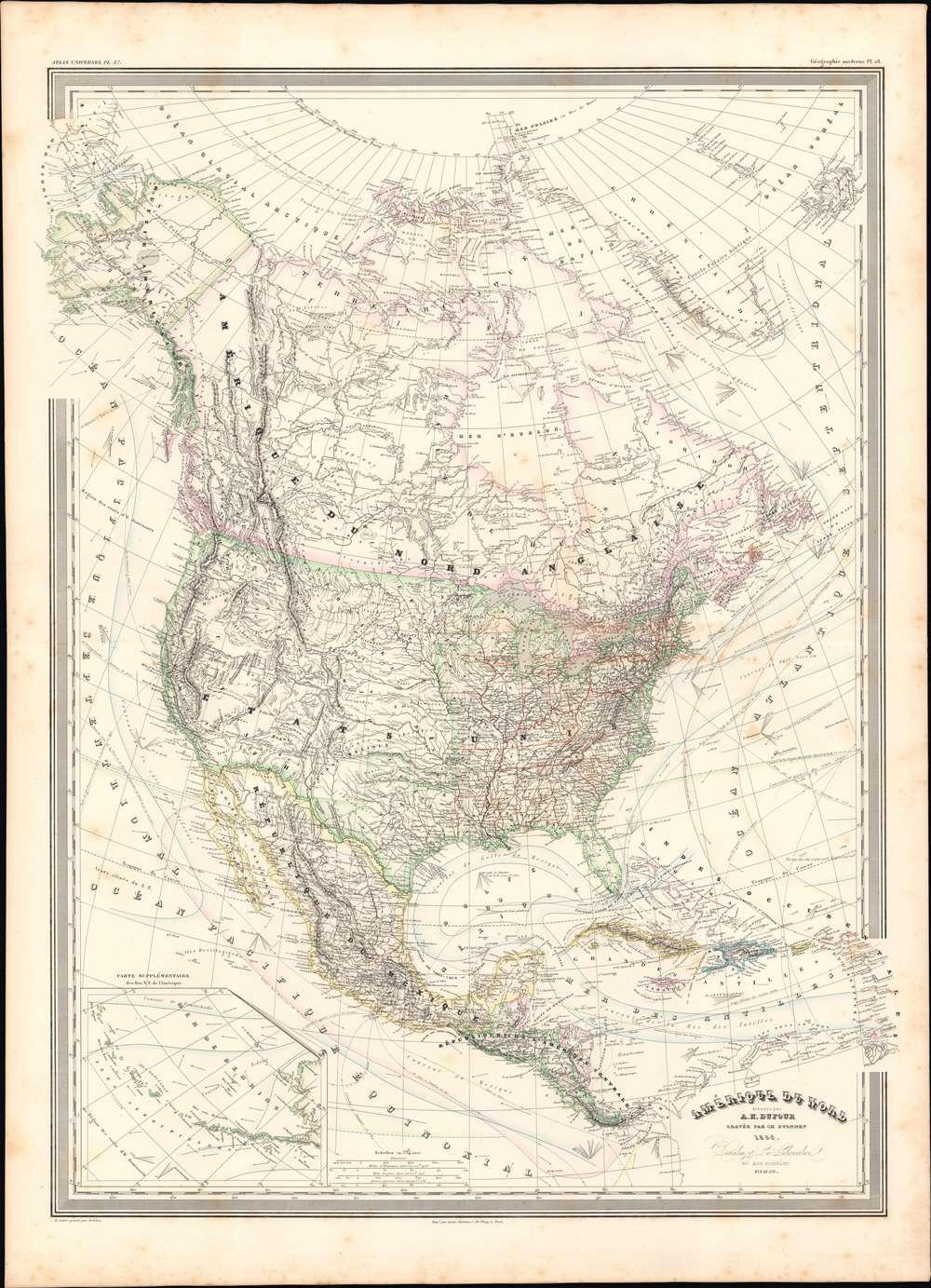
Amerique Du Nord.
1860 (dated) 31 x 23 in (78.74 x 58.42 cm) 1 : 12334000
1860 (dated) 31 x 23 in (78.74 x 58.42 cm) 1 : 12334000
Description
This is a finely detailed large format 1860 elephant folio map of the North America on Mercator's projection by the French cartographer Auguste-Henri Dufour. This map covers the entire continent from the Arctic to the northern part of South America, inclusive of the West Indies, Central America, Mexico, the United States, Canada and Alaska. In addition to standard political and physical data, a wealth of cartographic information appears throughout, including nautical routes, currents, winds, notes on explorers, some offshore details, comments on the polar ice caps, notes on vegetation, and much more. An inset in the lower right focuses on the Aleutian Islands.
Publication History
This map was prepared by Auguste-Henri Dufour and engraved by Charles Dyonette for publication plate no. 37 in Armand Le Chevalier's 1860 edition of Atlas Universel, Physique, Historique et Politique de Geographie Ancienne et Moderne.CartographerS
Adolphe Hippolyte Dufour (1795 - 1865), also known as Auguste-Henri Dufour, was a Paris based map and atlas publisher active in the middle to late 19th century. Dufour claimed to be a student of another French cartographer, Emile Lapie. He is known to have worked with numerous other French cartographers, publishers, and engravers of the period including Andriveau-Goujon, Charles Dyonnet, and Duvotenay. His corpus includes numerous maps and atlases, the most striking of which is probably his monumental elephant folio Atlas Universel Physique, Historique et Politique Geographie Ancienne et Moderne. Dufour's student and successor was Alexandre Vuillemin. More by this mapmaker...
Charles Dyonnet (fl. c. 1822 - c. 1880) was an extremely active Paris based engraver working in the mid to late 19th century. From his offices at 220 Rue St. Jacques, Paris, Dyonnet engraved numerous maps for many of the most prominent 19th French cartographic publishers including Vuillemin, Dufour, Fremin and Duvotenay. From 1850-1861, he held the coveted position of "Graveur du Dépot de la Marine," and in this position engraved numerous French naval and military maps. Dyonnet had a detail oriented and aesthetically minded hand and is responsible from some of the most beautiful French maps to emerge during the 19th century. Learn More...
Source
Chevalier, A., Atlas Universel, Physique, Historique et Politique de Geographie Ancienne et Moderne, (Paris) 1860.
Condition
Very good. Minor wear along original fold lines. Minor spotting at places.
References
Rumsey 5020.041.