This item has been sold, but you can get on the Waitlist to be notified if another example becomes available, or purchase a digital scan.
1783 Vaugondy Map of South America
AmeriqueMeridionale-vaugondy-1757$125.00

Title
Amerique Meridionale, dressee, sur les Memoires les plus recents et assujetie aux observations astronomique.
1783 (dated) 19.5 x 24 in (49.53 x 60.96 cm) 1 : 20000000
1783 (dated) 19.5 x 24 in (49.53 x 60.96 cm) 1 : 20000000
Description
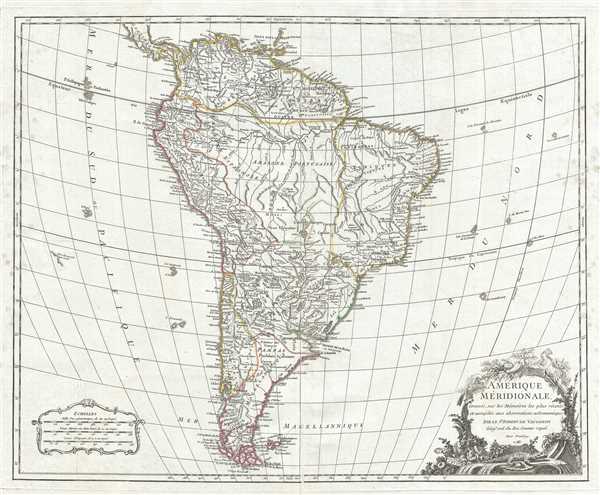
This is a beautiful 1783 map of South America by Robert de Vaugondy. It covers the continent of South America from Panama to Tierra del Fuego and Cape Horn. It offers excellent detail throughout showing mountains, rivers, forests, swamps, cities and a host of additional topographic features.
Vaugondy identifies the mythical Laguna de Xarayes, supposed gateway to paradise or El Dorado, as the northern terminus of the Paraguay River. The Xarayes, a corruption of 'Xaraies' meaning 'Masters of the River', were an indigenous people occupying what are today parts of Brazil's Matte Grosso and the Pantanal. When Spanish and Portuguese explorers first navigated up the Paraguay River, as always in search of El Dorado, they encountered the vast Pantanal flood plain at the height of its annual inundation. Understandably misinterpreting the flood plain as a gigantic inland sea, they named it after the local inhabitants, the Xaraies. The Laguna de los Xarayes almost immediately began to appear on early maps of the region and, at the same time, almost immediately took on a legendary aspect. Later missionaries and chroniclers, particularly Díaz de Guzmán, imagined an island in this lake and curiously identified it as an 'Island of Paradise'.
To the west of Chile, in the South Pacific Ocean, Vaugondy identifies the 'Land discovered by Davis', roughly where easter Island is today. Terre de Davis or Davis' Land was supposedly discovered in 1688 by an English navigator of the same name. Many historians argue whether or not Davis Land was actually eastern Island, but it does seem likely.
The lower right quadrant depicts an elaborate title cartouche with illustrations of an Indian woman, an alligator and a parrot. This map was drawn by Robert de Vaugondy and published in the 1757 issue of his Atlas Universal.
Cartographer
Robert de Vaugondy (fl. c. 1716 - 1786) was French may publishing from run by brothers Gilles (1688 - 1766) and Didier (c. 1723 - 1786) Robert de Vaugondy. They were map publishers, engravers, and cartographers active in Paris during the mid-18th century. The father and son team were the inheritors to the important Nicolas Sanson (1600 - 1667) cartographic firm whose stock supplied much of their initial material. Graduating from Sanson's maps, Gilles, and more particularly Didier, began to produce their own substantial corpus. The Vaugondys were well-respected for the detail and accuracy of their maps, for which they capitalized on the resources of 18th-century Paris to compile the most accurate and fantasy-free maps possible. The Vaugondys compiled each map based on their own geographic knowledge, scholarly research, journals of contemporary explorers and missionaries, and direct astronomical observation. Moreover, unlike many cartographers of this period, they took pains to reference their sources. Nevertheless, even in 18th-century Paris, geographical knowledge was limited - especially regarding those unexplored portions of the world, including the poles, the Pacific Northwest of America, and the interiors of Africa, Australia, and South America. In these areas, the Vaugondys, like their rivals De L'Isle and Buache, must be considered speculative or positivist geographers. Speculative geography was a genre of mapmaking that evolved in Europe, particularly Paris, in the middle to late 18th century. Cartographers in this genre would fill in unknown lands with theories based on their knowledge of cartography, personal geographical theories, and often dubious primary source material gathered by explorers. This approach, which attempted to use the known to validate the unknown, naturally engendered rivalries. Vaugondy's feuds with other cartographers, most specifically Phillipe Buache, resulted in numerous conflicting papers presented before the Academie des Sciences, of which both were members. The era of speculative cartography effectively ended with the late 18th-century explorations of Captain Cook, Jean Francois de Galaup de La Perouse, and George Vancouver. After Didier died, his maps were acquired by Jean-Baptiste Fortin, who in 1787 sold them to Charles-François Delamarche (1740 - 1817). While Delamarche prospered from the Vaugondy maps, he defrauded Vaugondy's window Marie Louise Rosalie Dangy of her rightful inheritance and may even have killed her. More by this mapmaker...
Source
Robert de Vaugondy, G., Atlas Universel, (Paris: Antoine Boudet) 1757.
The Atlas Universel was the crowning glory of the Robert de Vaugondy firm's atlas production. The atlas was revolutionary on many levels and exemplified the Vaugondy credo commode, complet, univorme, et suive (convenient, complete, uniform, and easy to use). The atlas thus consisted of a wide corpus of maps, both modern and historical, was of moderate height and width, and featured maps of uniform style and structure. They partnered with Antoine Boudet, a shrewd businessman and publisher with whom they had worked previously, to produce the 1752 first edition. To minimize his fiscal risk, Boudet sold the atlas first by subscription using a large prospectus, receiving in the process over 1100 pre-orders. The first edition appeared in 1752 and contained beautifully produced maps with elaborate freshly designed allegorical cartouche work, generally by Pierre-Edme Babel, Pierre Philippe Choffard, and Charles Nicholas Cochin. Most of the maps were engraved by the Delahaye firm, the payment for whose services ultimately led to legal disputes. Despite proving a popular work of astounding quality, the Atlas Universal received harsh criticism from fellow cartographers, particularly Philipppe Buache. Ever at odds with the Vaugondys, Buache's critical perspective may have been influenced more by political maneuvering than academic affront. The atlas was issued in multiple editions between 1752 and 1788. Later editions, issued after 1786, were taken over by Charles Delamarche, who inherited the Robert de Vaugondy firm and assumed Boudet's publication rights.
Condition
Very good. Minor wear along original centerfold. Some damage near lower margins, repaired on verso. Original platemark visible. Some spotting and offsetting.
References
Rumsey 3353.102. Pedley, Mary Sponberg Belle et Utile: The Work of the Robert de Vaugondy Family of Mapmakers, 470, state 3.