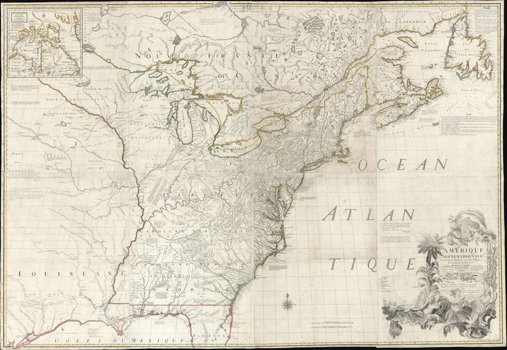
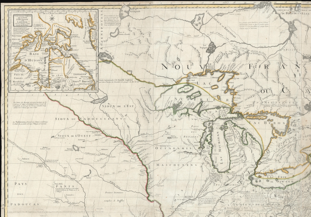
1777 Le Rouge / Mitchell Map of the Colonial Era United States
AmeriqueSept-lerougemitchell-1777$12,000.00

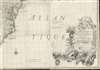

Title
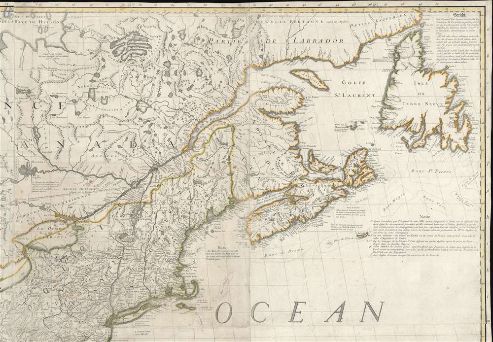
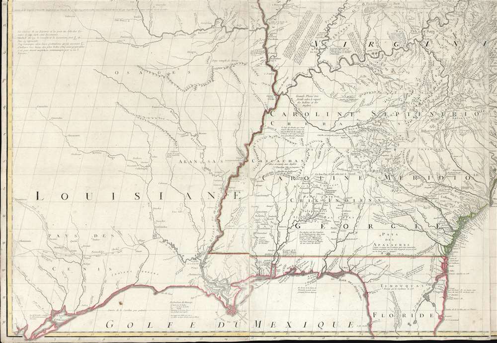
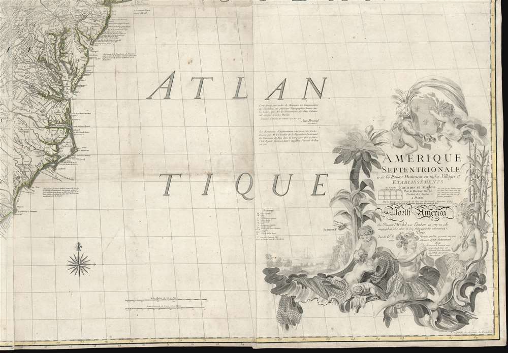
Amerique Septentrionale avec Les Routes, Distances et miles, Villages et Etablissements François et Anglois Par le Docteur Mitchel.
1777 (dated) 53.25 x 77.25 in (135.255 x 196.215 cm) 1 : 2000000
1777 (dated) 53.25 x 77.25 in (135.255 x 196.215 cm) 1 : 2000000
Description
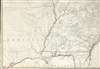
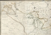
This is the important 1777 Georges Le Rouge French edition of the seminal John Mitchell map of the eastern part of North America. The Mitchell map is considered the single most important map in 18th-century American history. It was used as a primary reference for nearly every treaty and boundary dispute in colonial North America from the French and Indian War (1754 - 1763) through the late 19th century. The map is all the more astounding because this is Mitchell's one and only map - a truly remarkable feat of virtuosity.
This was a time of increasing political tensions and overlapping colonial claims. While embracing the most up-to-date cartographic sources, Mitchell advocated a very pro-British cartographic value system - expressing British claims to their fullest extent. As a propaganda mechanism, it was a brilliant move on the part of Halifax. By producing the most geographically advanced map, he expressed British intellectual dominance. At the same time, by overstating British territorial claims, he effectively produced a product that superseded the earlier French maps by J. B. B. D'Anville and others that previously had dominated the cartographic conversation. The marriage of geographical exactitude and political propaganda would prove a potent combination.
John Jay used a copy of the third edition during the negotiations of what would become the Treaty of Paris (1783). Thomas Jefferson recommended that Nicholas King use Mitchell's map in preparing a new map for Meriwether Lewis, saying: 'It was made with great care we know from what is laid down in those western parts with which we have lately become acquainted.'
The Origins of the Map
Before 1749, John Mitchell was not a mapmaker. He was an educated man, to be sure: a botanist, physician, and general intellectual. His education and charisma made him a favorite in British intellectual circles. His connection with Virginia made him the de facto London high society expert on all things American. With this in mind, George Montagu Dunk, 2nd Earl of Halifax (1716 - 1771), at the time head of the British Board of Trade, asked Mitchell to make a detailed, large-scale map of the French and English colonies in America. Mitchell took to the project with characteristic earnest dedication.This was a time of increasing political tensions and overlapping colonial claims. While embracing the most up-to-date cartographic sources, Mitchell advocated a very pro-British cartographic value system - expressing British claims to their fullest extent. As a propaganda mechanism, it was a brilliant move on the part of Halifax. By producing the most geographically advanced map, he expressed British intellectual dominance. At the same time, by overstating British territorial claims, he effectively produced a product that superseded the earlier French maps by J. B. B. D'Anville and others that previously had dominated the cartographic conversation. The marriage of geographical exactitude and political propaganda would prove a potent combination.
John Jay used a copy of the third edition during the negotiations of what would become the Treaty of Paris (1783). Thomas Jefferson recommended that Nicholas King use Mitchell's map in preparing a new map for Meriwether Lewis, saying: 'It was made with great care we know from what is laid down in those western parts with which we have lately become acquainted.'
Col. Lawrence Martin Speaks…
To get even a partial sense of the historic uses to which the map was put, we quote Col. Lawrence Martin, the second chief of the Library of Congress Geography and Map Division:[Mitchell's map] is thought to have been in use in the British House of Commons during the debate on the Quebec Act of 1774; it is known to have hung in the halls of Congress in 1802 and several times subsequently. It was used ... in the discussions of British land grants in the Ohio and Mississippi valleys, and in scores of controversies involving the boundary lines existing at the time of its publication. Great Britain and the United States agreed to its official status in the Convention of September 29, 1827.... it exerted substantial influence in the negotiation and ratification of the Webster-Ashburton Treaty of 1842, and serious argument was based upon it by Great Britain before the Court of Arbitration at The Hague in 1910 in connection with the North Atlantic Coast Fisheries Arbitration. It was submitted in evidence before the Law Lords of the British Privy Council in 1926 in the appeal of Price Brothers and Company, Limited, from a judgment of the Supreme Court of Canada, and in 1926-27 in the Canada-Newfoundland (Labrador) boundary case. It was used as evidence before the Supreme Court of the United States in the Wisconsin-Michigan boundary case, in 1926-27 in the Great Lakes level case, and in 1932 in the New Jersey-Delaware boundary case.
Publication History and Census
Mitchell's map was first published by Andrew Millar in 1755 - one year after the outbreak of the French and Indian War. The first issue was followed by a second edition in 1757, which added additional textual content regarding Mitchell's source material. After Mitchell's death in 1768, the plates were purchased by Jefferys and Faden, who revised the map and issued a third edition in 1773-74. Faden published a fourth edition in 1775, changing the title to A Map of the British Colonies in North America. Numerous editions followed, including the present French edition, as here, which, despite pro-British content, was still the premier map of eastern North America. Covens and Mortier also issued a Dutch edition - which is extremely scarce on the market. All examples are desirable, with the first three British editions published in Mitchell's lifetime holding primacy. The present Le Rouge edition is the only full-size example of the Mitchell reasonably obtainable by collectors and, as such, is highly desirable.CartographerS
John Mitchell (April 13, 1711 – February 29, 1768) was and British-American mapmaker of great significance. He is known for one and only one map, the 'Mitchell Map', considered the most important map in 18th century American history. Mitchell was born in Lancaster County, Virginia, the son of a prosperous planter and merchant. Like many of his social peers, he was educated in Europe, at Scotland at Edinburgh University, where he studied medicine. Mitchell practiced medicine in Virginia for a short time prior to the French and Indian War. He was elected to the original American Philosophical Society in 1744. In 1745 Mitchell argued that a series of epidemics occurring in Virginia were due to unsanitary troop ships from Britain - at the time a revolutionary idea. He relocated to London in 1746 - presumably for the agreeable climate. Mitchell never practiced medicine in London, but was known to be an avid botanist, and was considered an exotic plant expert in London society circles. He was elected as a fellow of the Royal Society in November 1748, his candidature citation describing him as
A Gentleman of great merit and Learning, who Some time Since communicated to the Royal Society a very curious dissertation concerning the Colour of the skin in Negroes, and who from his long residence in Virginea, and from his great application to the Study of Natural history, especially Botany, is very well acquainted with the vegetable productions of North America, being desirous of being admitted a fellow of the Royal Society, is recommended by us from our personal knowledge of him as highly deserving the Honour he desires, as we believe he will be (if chosen) a usefull and valuable member of our Body.As an educated American adopted into British high society, Mitchell became the de facto expert on all matters North American. In 1749, during a time of ever-increasing political tensions between British and French interests in America, Lord Halifax contracted Mitchell to produce a large and detailed map of British and French dominions in America. While embracing the most advanced geographical data, Mitchell also advocated pro-British interpretation of political boundaries. The resulting map was thus geographically unimpeachable and reframed the cartographic perspective from French to British terms. The map proved significant and was used in most subsequent treaties. Michell issued 3 editions in his lifetime. He died in London in 1768. More by this mapmaker...
Georges-Louis Le Rouge (c. 1707 - c. 1790) was a Paris based map publisher operating in the middle part of the 18th century. Le Rouge was born in Hanover Germany as Georg Ludwig, where he was educated and employed as a military engineer and surveyor. His father may have been the French architect Louis Remy de la Fosse (1659 - 1726), which would explain his early education in both engineering and draftsmanship. He assisted his father on a large-scale plan of Darmstadt, which he completed following his father's death in 1726. He may have remained in Darmstadt, but little is known of his life from 1726 - 1736, when he appears in Paris. Le Rouge acquired a position as military and civil engineer for King Louis XV and Louis XVI. Around this time, he Francophied his name to 'Le Rouge'. In 1840, he set up shop on the Rue Des Grands Augustins as an engraver, book publisher, and map publisher. He partnered with the English cartographer and engineer John Rocque (1709 - 1762), who became an important source for English maps, which Le Rouge re-engraved for French use. Despite being born German and adopting Paris as his home, Le Rouge was an ardent Anglophile and spent much of his time translating English books and maps into French. During his active period of roughly forty years Le Rouge produced thousands of maps and diagrams ranging from city and town plans, to atlases, plans of military campaigns and sea charts. He was a friend and correspondent of Benjamin Franklin (1706 - 1790), with whom he produced the important 1769 Franklin/Folger Map of the Gulf Stream. Franklin, who met Le Rouge in Paris, writes that 'He [Le Rouge] is, I believe, a proper person.' He was awarded for his diligence with the impressive but unstipended honorific 'Geographe du Roi'. They may not have served him swell during the French Revolution (1789 - 1799), as his last known work was published in 1789, just before the storming of the Bastille. The exact date of Le Rouge's death remains a mystery. By most estimates, he is believed to have been alive in 1790, but may have lived as long as 1794. Learn More...
Condition
Very good. Light soiling. 16 sheets joined, as issued.
References
OCLC 54640476. Ristow, Walter, A la carte, p. 112. LC Maps of North America, 1750-1789, 51. Library of Congress, G3300 1777 .M5. Boston Public Library, Leventhal Collection, G3300 1776 .M57. Rumsey 0510.000. McCorkle, B. B, New England in Early Printed Maps 1513 - 1800, #777.15. Cumming, W., The Southeast in Early Maps, #293.