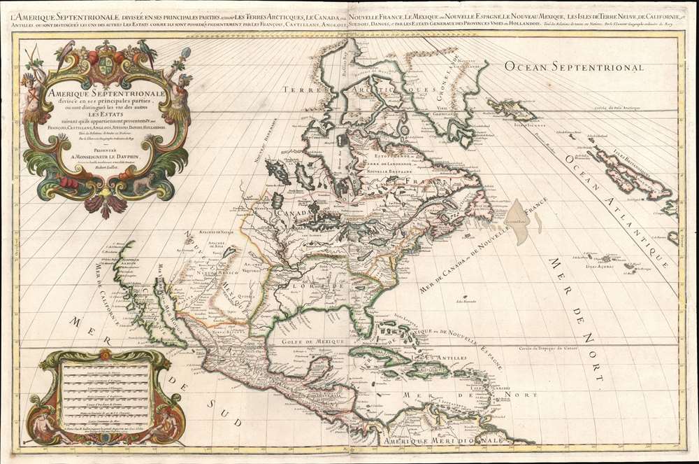
1719 Jaillot Map of North America - last edition!
AmeriqueSeptentrionale-jaillot-1719$2,800.00


Title
Amerique septentrionale divisee en ses principales parties, ou sont distingues les vns des autres les estats suivant qu'ils appartiennent presentemet aux Francois, Castillans, Anglois, Suedois, Danois, Hollandois, tiree des relations de toutes ces nations par le S. Sanson, Geographe Ordinaire du Roy.
1719 (dated) 23 x 35 in (58.42 x 88.9 cm) 1 : 16000000
1719 (dated) 23 x 35 in (58.42 x 88.9 cm) 1 : 16000000
Description
A scarce 1719 elephant folio map of North America issued by Alexis-Hubert Jaillot on an impressive scale. This is the scarce final edition of Jaillot's map featuring numerous updates to California, the Mississippi Valley, and the Eastern Seaboard. After the first edition, it is considered the most important due to its many significant changes that reflect the most up-to-date discoveries and speculations. The map covers all of North America and Central America, from Baffin Bay to the Spanish Main. It extends westward to include a highly speculative California and eastwards past the Azores to include the British Isles.
Sanson's Cartography
Jaillot derived this expanded format map from the earlier work of Nicholas Sanson, a figure who revolutionized French cartography. We can trace the fundamental design of this map to two Sanson maps. First, his 1666 map of North America - on which most of the basic cartography is based. Second, his 1657 map of California, which influenced the rise of the Insular California theory - despite the fact that in this 1719 edition, the northern part of Insular California has been removed, reflecting general acceptance that California was not an island. The present edition is further influenced by the 1698 map of Louis Hennepin and the cartography of René-Robert Cavelier, Sieur de La Salle.Fascinating Great Lakes
Jaillot's map also offers an ephemeral perspective on the Great Lakes. While all five lakes are present, Lake Superior (Lac de Tracy) and Lake Michigan (Lac des Illinois) are definitively lakes, a major change over earlier editions wherein these lakes were open at their westernmost extremes, thus illustrating the primitive state of exploration in the region as well as the high hopes of European monarchs that one of these lakes may provide a passage to the Pacific and the lucrative markets of Asia. Lake Huron is identified according to its original Huron-Petun (Wyandot) name, Karegnondi (tr. 'Big Lake').Mississippi River
The Mississippi River is relocated well to the west of its actual position, with its mouth corresponding roughly to the Sabine River. Although incorrect, this change represents a major advancement over previous maps in this series. Earlier states conflate the Mississippi with the Chucagua, which is here also mapped roughly where the actual Mississippi enters the Gulf of Mexico. Jaillot's reasoning behind this relocation relates to the cartography of Father Louis Hennepin, who issued an influential map corresponding to this error in 1698, and the subsequent cartography of La Salle.Great Freshwater Lake of the Southeast
In Spanish Florida, which extends north to include most of the American Southeast, Lake Apalache, often called Lacus Aquae Dulces or the 'Freshwater Lake of the American Southeast' is noted. This lake, first mapped by De Bry and Le Moyne in the mid-16th century, is a mis-mapping of Florida's Lake George. While Theodor De Bry, working in 1565, correctly mapped the lake as part of the River May or St. John's River, subsequent navigators and cartographers in Europe erroneously associated it with the Savannah River, which, instead of flowing south from the Atlantic (like the May), flowed almost directly from the northwest. This error was taken up by Hondius and Mercator, who, in their 1606 map, inverted the course of the May River, thus situating this lake far to the northwest in Appalachia. Consequently, 'through mutations of location and size [this] became the great inland lake of the Southeast' (Cumming, 478) - an apocryphal cartographic element that would remain one of Le Moyne's most tenacious legacies. Lake Apalache was subsequently relocated somewhere in Carolina or Georgia, where Jaillot maps it and where it would remain for several hundred years.Publication History and Census
This map was first issued independently as early as 1674 but was not published in Jaillot's spectacular Atlas Nouveau until 1681. The present edition, dated 1719, is identified by Burden as the final state. Unlike earlier states, which exhibit only minor changes over the first edition, the present example exhibits extensive updating and re-engraving, marking it as the most significant state after the original 1674 first edition.CartographerS
Alexis-Hubert Jaillot (c. 1632 - 1712) followed Nicholas Sanson (1600 - 1667) and his descendants in ushering in the great age of French Cartography in the late 17th and 18th century. The publishing center of the cartographic world gradually transitioned from Amsterdam to Paris following the disastrous inferno that destroyed the preeminent Blaeu firm in 1672. Hubert Jaillot was born in Franche-Comte and trained as a sculptor. When he married the daughter of the Enlumineur de la Reine, Nicholas I Berey (1610 - 1665), he found himself positioned to inherit a lucrative map and print publishing firm. When Nicholas Sanson, the premier French cartographer of the day, died, Jaillot negotiated with his heirs, particularly Guillaume Sanson (1633 - 1703), to republish much of Sanson's work. Though not a cartographer himself, Jaillot's access to the Sanson plates enabled him to publish numerous maps and atlases with only slight modifications and updates to the plates. As a sculptor and an artist, Jaillot's maps were particularly admired for their elaborate and meaningful allegorical cartouches and other decorative elements. Jaillot used his allegorical cartouche work to extol the virtues of the Sun King Louis IV, and his military and political triumphs. These earned him the patronage of the French crown who used his maps in the tutoring of the young Dauphin. In 1686, he was awarded the title of Geographe du Roi, bearing with it significant prestige and the yearly stipend of 600 Livres. Jaillot was one of the last French map makers to acquire this title. Louis XV, after taking the throne, replaced the position with the more prestigious and singular title of Premier Geographe du Roi. Jaillot died in Paris in 1712. His most important work was his 1693 Le Neptune Francois. Jalliot was succeeded by his son, Bernard-Jean-Hyacinthe Jaillot (1673 - 1739), grandson, Bernard-Antoine Jaillot (???? – 1749), and the latter's brother-in-law, Jean Baptiste-Michel Renou de Chauvigné-Jaillot (1710 - 1780). More by this mapmaker...
Nicolas Sanson (December 20, 1600 - July 7, 1667) and his descendants were the most influential French cartographers of the 17th century and laid the groundwork for the Golden Age of French Cartography. Sanson was born in Picardy, but his family was of Scottish Descent. He studied with the Jesuit Fathers at Amiens. Sanson started his career as a historian where, it is said, he turned to cartography as a way to illustrate his historical studies. In the course of his research some of his fine maps came to the attention of King Louis XIII who, admiring the quality of his work, appointed Sanson Geographe Ordinaire du Roi. Sanson's duties in this coveted position included advising the king on matters of geography and compiling the royal cartographic archive. In 1644, he partnered with Pierre Mariette, an established print dealer and engraver, whose business savvy and ready capital enabled Sanson to publish an enormous quantity of maps. Sanson's corpus of some three hundred maps initiated the golden age of French mapmaking and he is considered the 'Father of French Cartography.' His work is distinguished as being the first of the 'Positivist Cartographers,' a primarily French school of cartography that valued scientific observation over historical cartographic conventions. The practice result of the is less embellishment of geographical imagery, as was common in the Dutch Golden Age maps of the 16th century, in favor of conventionalized cartographic representational modes. Sanson is most admired for his construction of the magnificent atlas Cartes Generales de Toutes les Parties du Monde. Sanson's maps of North America, Amerique Septentrionale (1650), Le Nouveau Mexique et La Floride (1656), and La Canada ou Nouvelle France (1656) are exceptionally notable for their important contributions to the cartographic perceptions of the New World. Both maps utilize the discoveries of important French missionaries and are among the first published maps to show the Great Lakes in recognizable form. Sanson was also an active proponent of the insular California theory, wherein it was speculated that California was an island rather than a peninsula. After his death, Sanson's maps were frequently republished, without updates, by his sons, Guillaume (1633 - 1703) and Adrien Sanson (1639 - 1718). Even so, Sanson's true cartographic legacy as a 'positivist geographer' was carried on by others, including Alexis-Hubert Jaillot, Guillaume De L'Isle, Gilles Robert de Vaugondy, and Pierre Duval. Learn More...
Source
Jaillot, Alexis-Hubert, Atlas Nouveau, (Paris) 1719.
Condition
Very good. A few minor edge repairs and verso reinforcements Platemark visible. Centerfold wear. Blank on verso. Minor wormhole repairs at center near Great Lakes. Two sheets, joined by publisher. Minor buckling.
References
OCLC 17446537. 'Map Collector's Circle' #8 (Tooley, R.V. California as an island, no. 37). Wagner, H. R., The Cartography of the Northwest Coast of America to the Year 1800, #409b. Burden, P., The Mapping of North America II, #438, state 4.