This item has been sold, but you can get on the Waitlist to be notified if another example becomes available, or purchase a digital scan.
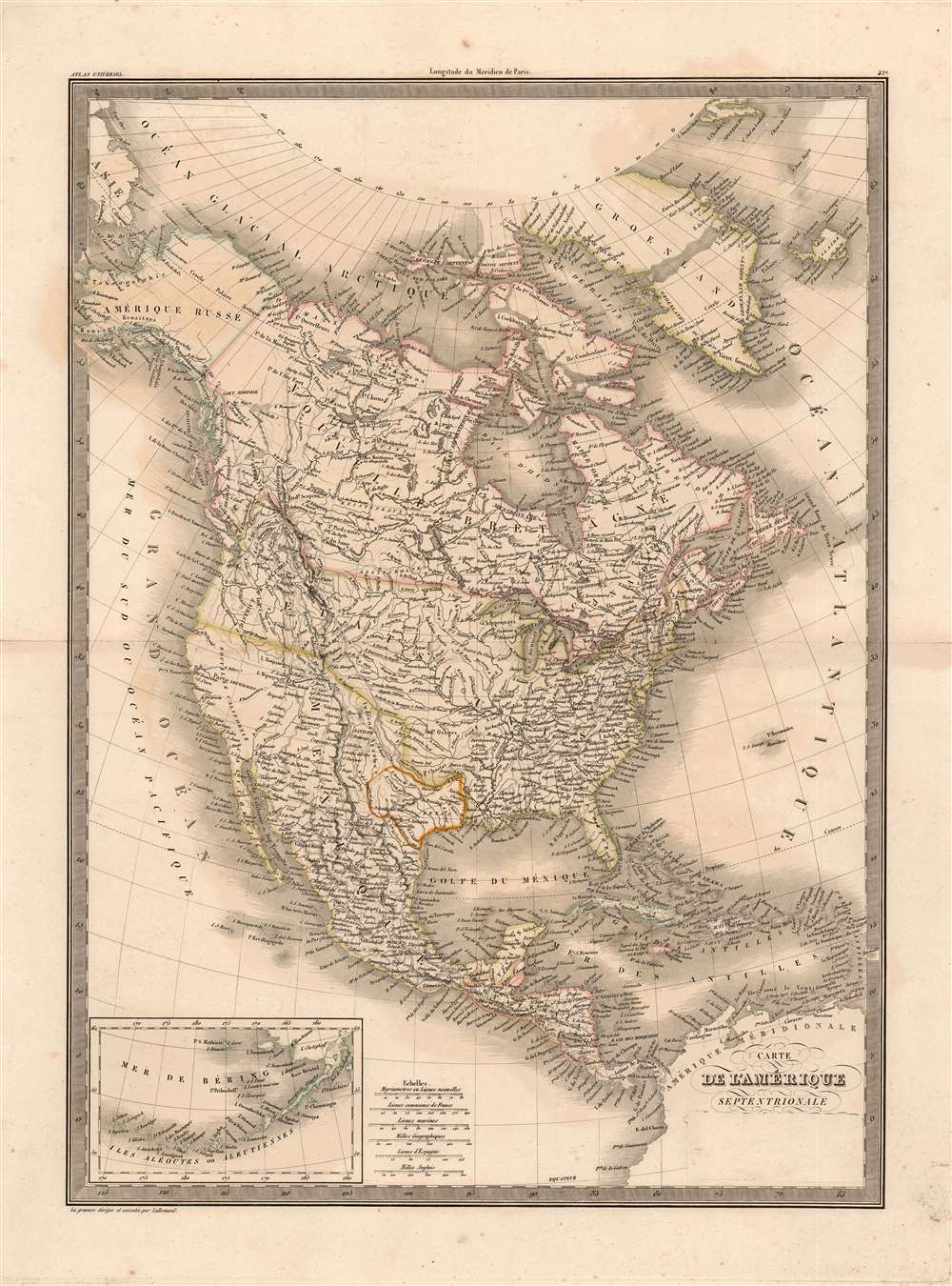
1838 Lapie Map of North America and the Republic of Texas
AmeriqueSeptentrionale-lapie-1838$250.00

Title
Carte de l'Amerique Septentrionale.
1838 (undated) 21.5 x 15.5 in (54.61 x 39.37 cm) 1 : 19000000
1838 (undated) 21.5 x 15.5 in (54.61 x 39.37 cm) 1 : 19000000
Description
A fine example of M. Lapie’s 1838 map of North America. The map covers the entire North American continent and Greenland, embracing the Caribbean. An inset in the lower left corner details the Bering Sea and the Aleutian Islands. This map was engraved by Armand Joseph Lallemand as plate no. 42 in the first edition of M. Lapie’s important Atlas Universel, and it was retained in later editions with minor updates. The original hand color this example conforms to that of the 1838 edition, which is of significance because it is with color that the mapmaker illuminates the political borders on the map, particularly that of the Republic of Texas.
It would not be until the voyages of John Davis in 1585-87 that it would become clear that Frobisher had not been exploring between America and Asia, but between Greenland and North America. The Davis Strait (illustrated here between Greenland and Labrador) is named after him. Even with this revelation, it was believed that Frobisher had indeed discovered a strait, but that it was, in fact, located on the southern tip of Greenland. Thus, most sixteenth and seventeenth century works depicting Frobisher's Strait locate it in southern Greenland stretching from the east coast to the Davis Strait. Later editions of this map (amended by Tardieu) remove the strait (as well as the 'L' in 'Greenland.').
Republic of Texas
The Republic of Texas was a short-lived nation established in March of 1836 when it ceded from Mexico. Following the independence of Mexico from Spain, the American Stephen Fuller Austin lead a group of 300 Empresarios to settle Texas, near Austin, where they received a grant from the Mexican government. As more Americans moved to Texas, resentment and strife began to build between the American settlers and Mexican authorities. This and other factors ultimately led to the Texan Revolution in 1835 and the declaration of Texan independence in 1836. Texas remained an independent republic until it joined the United States 10 years later in 1846.Texas Borders
The borders of the Republic of Texas were in dispute from the earliest days of the Texan Revolution. The Republic-claimed borders followed the Treaties of Velasco between the newly created Texas Republic and Mexican leader, Antonio López de Santa Anna. The treaties established an eastern boundary following the 1819 Adams-Onís Treaty between the United States and Spain, which established the Sabine River as the eastern boundary of Spanish Texas and western boundary of the Missouri Territory. The Republic's southern and western boundary with Mexico was more nuanced. Texas claimed the Rio Grande del Norte as its western and southernmost border, while Mexico argued for a boundary much further east at the Nueces River. When Texas was annexed into the United States, the agreement followed the Republic claimed boundary, thus absorbing Mexican claimed territory as far west as Santa Fe. This escalated already existing tensions between the United States, the former Republic of Texas, and Mexico, ultimately triggering for the Mexican-American War (1846 - 1848).France Recognizes the Republic of Texas
When Texas ceded from Mexico on April 21 of 1836, it immediately sought legitimacy through diplomatic appeals to major world powers - most of which were in Europe. Most European powers were reluctant to recognize the self-proclaimed Republic until it became clear that it could survive and what diplomatic ramifications, if any, formal recognition might yield. Nonetheless, France under King Louis Phliippe recognized Texas on September 25, 1839. This act may have been partially trade inspired, and partially motivated by French antipathy towards Mexico following the First French Intervention or Pastry War (1838 - 1839). Recognizing Texas diplomatically allowed France to open official trade channels, particularly for cotton, a vital commodity in Europe and an increasing cause of tension between France and Britain. Moreover, the recognition of Texas accelerated the destabilization of Mexico, increasing the probability that any colonial aspirations the French may have had in seizing California would be successful.Greenland/ Frobisher's Strait
Greenland is shown bisected by a massive strait, extending from Ilulissat (formerly Jakobshavn) in the west to Traill Island in the East. Frobisher's Strait began appearing on maps in southern Greenland following Sir Martin Frobisher's 1574 expedition to locate the Northwest Passage. When Frobisher returned from his voyage, he declared that he had, in fact, discovered a strait with America on one side and Asia on the other, which he of course named after himself. It quickly became evident to his contemporaries that he had been mistaken about his true location, but had, in fact, been traveling through a strait across southern Greenland. This strait, still known as Frobisher's Strait, quickly began to appear on maps of the era. Cartographers and other explorers, however, could not completely agree on the correct location for Frobisher's Strait, which is we believe to be the reason for not one, but three different straits across southern Greenland in this work by Bellin.It would not be until the voyages of John Davis in 1585-87 that it would become clear that Frobisher had not been exploring between America and Asia, but between Greenland and North America. The Davis Strait (illustrated here between Greenland and Labrador) is named after him. Even with this revelation, it was believed that Frobisher had indeed discovered a strait, but that it was, in fact, located on the southern tip of Greenland. Thus, most sixteenth and seventeenth century works depicting Frobisher's Strait locate it in southern Greenland stretching from the east coast to the Davis Strait. Later editions of this map (amended by Tardieu) remove the strait (as well as the 'L' in 'Greenland.').
Publication History and Census
This map was among those created by Pierre and Alexandre Lapie and engraved by Armand Joseph Lallemand for publication as plate no. 42 in the 1830 and later editions of their Atlas Universel de Géographie Ancienne et Moderne. The original hand color on this example conforms to that which we have identified on 1838 examples of the map. We have also seen examples of the 1838 with the publishers' imprint masked as is evident here. Masking a portion of a lithograph allowed the publishers to excise information from a map without damaging the printing medium; in this case, it would appear that Lapie intended this map to be added to another, unidentified, publisher's atlas whose own imprint could then be pasted on. While we have seen a similarly masked example of the map on the market, we do not see any identified in OCLC. We find separate examples (catalogued as 1830 issues) only at Florida State University and the University of Texas at Arlington. Various editions of the Atlas Universel appear in many institutional collections, eleven of which are of 1838 editions.CartographerS
Pierre M. Lapie (fl. 1779 - 1850) and his son Alexandre Emile Lapie (fl. 1809 - 1850) were French cartographers and engravers active in the early part of the 19th century. The Lapies were commissioned officers in the French army holding the ranks of Colonel and Capitan, respectively. Alexander enjoyed the title of "First Geographer to the King", and this title appears on several of his atlases. Both father and son were exceptional engravers and fastidious cartographers. Working separately and jointly they published four important atlases, an 1811 Atlas of the French Empire (Alexander), the 1812 Atlas Classique et Universel (Pierre), the Atlas Universel de Geographie Ancienne et Modern (joint issue), and the 1848 Atlas Militaire (Alexander). They also issued many smaller maps and independent issues. All of these are products of exceptional beauty and detail. Despite producing many beautiful maps and atlases, the work of the Lapie family remains largely underappreciated by most modern collectors and map historians. The later 19th century cartographer A. H. Dufour claimed to be a student of Lapie, though it is unclear if he was referring to the father or the son. The work of the Lapie firm, with its precise engraving and informational density, strongly influenced the mid-19th century German commercial map publishers whose maps would eventually dominate the continental market. More by this mapmaker...
Armand Joseph Lallemand (c. 1810 - 1871) was an engraver and map publisher based in Paris during the mid-19th century. Most of Lallemand's work focused on landscapes and building vies, though he did take part in a few cartographic ventures, including the production of an atlas with Alexandre Emile Lapie and several tourist pocket maps of Paris. Learn More...
Source
Lapie, Alexander and Lapie, Pierre, Atlas Universel de Géographie Ancienne et Moderne (Paris) 1838.
Condition
Very good condition. Some toning and marginal spotting. Original outline color.
References
Compare with Rumsey 2174.042, also OCLC 39667363.