This item has been sold, but you can get on the Waitlist to be notified if another example becomes available, or purchase a digital scan.
1772 Lotter Map of North America
AmeriqueSeptentrionale-lotter-1772$450.00

Title
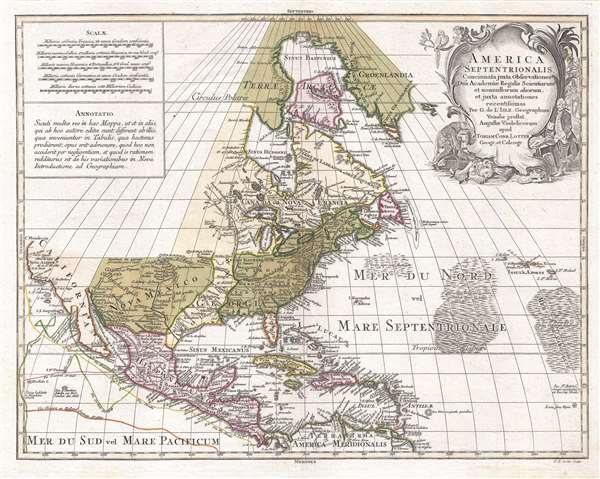
America Septentrionalis, concinnata juxta observationes Dñn Academiæ Regalis Scientiarum et nonnullorum aliorum, et juxta annotationes recentissimas…
1772 (undated) 19.5 x 24 in (49.53 x 60.96 cm) 1 : 19000000
1772 (undated) 19.5 x 24 in (49.53 x 60.96 cm) 1 : 19000000
Description
A visually striking c. 1772 old color Tobias Conrad Lotter map of North America. Centered roughly on New York City, the map covers from Baffin Bay to the northern part of South America and from California to the Azores. Cartographically the map is based upon the c. 1700 work of the French cartographer Guillaume de L'Isle. Nonetheless, it is not without updates and revisions.
An Ephemeral Political Configuration
The map reveals a post-French and Indian War (1754 - 1763) / Pre-American Revolutionary War (1775 – 1783) political configuration. The English colonies have extended tehir claims westward as far as the Mississippi. Louisiana is still distinct, but in fact, at this time, all of Louisiana west of the Mississippi had been ceded to Spain for its assistance against France in the previous war. Florida at this time, also distinct, is a British territory per the 1763 Treaty of Paris, however, it would be returned to Spain in 1783.
California: Insular or Peninsular
Since the map is drawing from a c. 1700 source, it is notable that California, while initially appearing peninsular, has indistinct borders, suggesting uncertainty with regard to whether it is an island or a peninsula. In the late 17th and early 18th centuries it was briefly believe that California was an island and it appears and many maps of the period as such. Although this dispute had been technically resolved as early as 1710 by the writings of the Italian Jesuit Eusebio Francisco Kino, whose travels in the region definitively proved that California was in fact a peninsula, cartography in Europe was often derivative and some map publishers, like Lotter here, were slow to adapt the most up to date data.
St. Brenden's Sinking Island
Also of interest, the map depicts the speculative Island of St. Brendan (San Borondón) in the midst of the Sargasso sea near the right border. Supposedly San Borondón is the 8th Canary Islands. Legend attributes its discover to the Irish monk St. Brenden, who it is said, discovered it in the 15th century. The island, according to the legend, is nearly impossible to reach for a number of mystical and mysterious reasons: it moved, it was shrouded in mist, surrounded by violent storms, and inhabited by 'fire-hurling demons.' Nonetheless, through religious zeal and perseverance, Brenden reached the island, where he established a church and lived for six years. One day, the island began to move and at last, sink. Brenden and his cohorts fled back to Europe where they shared their fabulous tale. The island was repeatedly sighted throughout the 16th, 17th, and 18th centuries, but finally disappeared from most map by the early 19th century. Today myth-mongers conflate St. Brenden's Island with the apocryphal island of Atlantis.
This map was published by Tobias Conrad Lotter in Augsburg, Germany. The map was engraved by Lotter's oldest son, Georg Friedrich Lotter.
CartographerS
Tobias Conrad Lotter (1717 - 1777) was a German engraver and map publisher. Lotter was the son of a baker and city guardsman, but married Euphrosina (1709 - 1784) Seutter, elder daughter of the prominent map publisher Matthäus Seutter. He began working at his is father-in-law's map business about 1740. Between 1740 and 1744 he produced, under Seutter's imprint, the Atlas minor, Praecipua orbis terrarum imperia, regna et provincias, Germania potissimum tabelli. Upon Seutter's death, in 1757, the firm's stock was taken over by his son, Albrecht Karl Seutter (1722 - 1762), who himself died in 1762, just a few years later. The remaining Seutter map plates were subsequently divided between Lotter and the publisher Johan Mitchell Probst (1727 - 1776). With the support of his sons, Matthäus Albrecht (1741 - 1810), Georg Friedrich (1744 - 1801) and Gustav Conrad (1746-1776), Tobias Conrad Lotter succeeded in building on the economic success and professional reputation of his father-in-law. In time, Lotter became one of the most prominent mid-18th century map publishers working in the German school. After Lotter's death in 1777, the business was taken over by his two eldest sons, who, lacking their father's business acumen, presided over the firm's slow decline. It was nonetheless passed on to a subsequent generation of Lotters, Matthäus Albrecht Lotter's sons, Gabriel (1776 - 1857) and Georg Friedrich (1787 - 1864), who pushed it into further decline until it faded out in the early-19th century. More by this mapmaker...
The De L'Isle family (fl. c. 1700 - c. 1760) (also written Delisle) were, in composite, a mapmaking tour de force who redefined early 18th century European cartography. Claude De L'Isle (1644 -1720), the family patriarch, was Paris based a historian and geographer under Nicholas Sanson. De L'Isle and his sons were proponents of the school of "positive geography" and were definitive figures, defining the heights of the Golden Age of French Cartography. Of his twelve sons, four, Guillaume (1675 - 1726), Simon Claude (1675 - 1726), Joseph Nicholas (1688 - 1768) and Louis (1720 - 1745), made a significant contributions to cartography. Without a doubt Guillaume was the most remarkable member of the family. It is said that Guillaume's skill as a cartographer was so prodigious that he drew his first map at just nine years of age. He was tutored by J. D. Cassini in astronomy, science, mathematics and cartography. By applying these diverse disciplines to the vast stores of information provided by 18th century navigators, Guillaume created the technique that came to be known as "scientific cartography", essentially an extension of Sanson's "positive geography". This revolutionary approach transformed the field of cartography and created a more accurate picture of the world. Among Guillaume's many firsts are the first naming of Texas, the first correct map of the Mississippi, the final rejection of the insular California fallacy, and the first identification of the correct longitudes of America. Stylistically De L'Isle also initiated important changes to the medium, eschewing the flamboyant Dutch style of the previous century in favor of a highly detailed yet still decorative approach that yielded map both beautiful and informative. Guillaume was elected to the French Academie Royale des Sciences at 27. Later, in 1718, he was also appointed "Premier Geographe du Roi", an office created especially for him. De L'Isle personally financed the publication of most of his maps, hoping to make heavy royalties on their sales. Unfortunately he met an untimely death in 1728, leaving considerable debt and an impoverished child and widow. De L'Isle's publishing firm was taken over by his assistant, Phillipe Buache who became, posthumously, his son in law. The other De L'Isle brothers, Joseph Nicholas and Louis De L'Isle, were employed in the Service of Peter the Great of Russia as astronomers and surveyors. They are responsible for cataloguing and compiling the data obtained from Russian expeditions in the Pacific and along the northwest coast of America, including the seminal explorations of Vitus Bering and Aleksei Chirikov. The De L'Isles, like their rivals the Vaugondys , must be considered speculative geographers. Speculative geography was a genre of mapmaking that evolved in Europe, particularly Paris, in the middle to late 18th century. Cartographers in this genre would fill in unknown areas on their maps with speculations based upon their vast knowledge of cartography, personal geographical theories, and often dubious primary source material gathered by explorers and navigators. This approach, which attempted to use the known to validate the unknown, naturally engendered many rivalries. The era of speculatively cartography effectively ended with the late 18th century explorations of Captain Cook, Jean Francois de Galaup de La Perouse, and George Vancouver. Learn More...
Condition
Very good.
References
Sellers, John R. and Van Ee, Patricia, Maps and Charts of North America, #126. Library of Congress, Map Division, G3300 1772 .L61.