This item has been sold, but you can get on the Waitlist to be notified if another example becomes available, or purchase a digital scan.
1662 Sanson Map of North America w/California as an Island
AmeriqueSeptentrionale-sanson-1662$500.00

Title
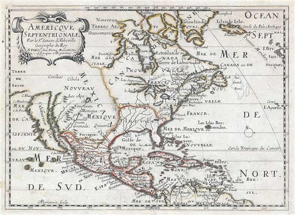
Americque Septentrionale. Par le Sr. Sanson d'Abbeville Geograph du Roy.
1662 (undated) 8 x 11.5 in (20.32 x 29.21 cm) 1 : 40000000
1662 (undated) 8 x 11.5 in (20.32 x 29.21 cm) 1 : 40000000
Description
A very attractive 1662 Nicolas Sanson map of North America. Sanson's map covers all of North America from Baffin Bay and Greenland, south to include all of Central America, the West Indies, and parts of the Spanish Main, it similarly extends from California eastwards to the Azores and the British Isles. Cartographically, this map is a reduced version of Sanson's own larger 1650 Amerique Septentrionale.
Our survey of this map will start with Sanson's striking rendering of California as an Island - a theory of which he was a major proponent. The idea of an insular California first appeared as a work of fiction in Garci Rodriguez de Montalvo's c. 1510 romance Sergas de Esplandian, where he writes
Further inland the mythic cities of Conibas, Quivara, and Cibola are identified. The latter two of these, Cibola and Quivara, are legendary cities of gold whose first documentation hails from the misadventures of Cabeza de Vaca and the explorations associated with the Coronado Expedition. Conibas is another mythical city, presumably situated on a lake high in the Canadian arctic, whose origins most likely trace to the Cartier Expedition. Cartier, it is said, noticed Indians trading with shells, wampum, which they called Conibatz. This later transliterated to Conibas.
In the province of the Apaches, roughly in the vicinity of modern day Great Salt Lake, a large lake appears from which the Rio de Norte (Colorado River) extends southward to drain into the Gulf of California. (Although the Colorado technically does flow into the Gulf of California, it has not done so on a regular basis for over 100 years.) Several identifiable cities appear along the river, including Santa Fe.
Further east still, the Great Lakes are presented in an embryonic form. The lakes Michigan and Superior extend westward indefinitely suggesting that they may in fact connect to the unexplored Pacific Northwest coast. Of the five lakes, only Lake Erie is unnamed - though it is repressed with a close approximation to accuracy. On the eastern Seaboard New York or New Amsterdam, is presented as an island well offshore. Plymouth and St. Augustine are also identified.
Nicolas Sanson issued this map to accompany his 1662 atlas of America entitled L'Amerique en Plusieurs Cartes. This map is known in six states, of which the present example corresponds to Burden's second. It was engraved by Abraham Peyrounin.
Our survey of this map will start with Sanson's striking rendering of California as an Island - a theory of which he was a major proponent. The idea of an insular California first appeared as a work of fiction in Garci Rodriguez de Montalvo's c. 1510 romance Sergas de Esplandian, where he writes
Know, that on the right hand of the Indies there is an island called California very close to the side of the Terrestrial Paradise; and it is peopled by black women, without any man among them, for they live in the manner of Amazons.Baja California was subsequently discovered in 1533 by Fortun Ximenez, who had been sent to the area by Hernan Cortes. When Cortez himself traveled to Baja, he must have had Montalvo's novel in mind, for he immediately claimed the Island of California for the King. By the late 16th and early 17th century ample evidence had been amassed, by explorations of the region by Francisco de Ulloa, Hernando de Alarcon and others, that California was in fact a Peninsula and not and island. However, by this time other factors were in play. Francis Drake had sailed north and claimed 'New Albion' near modern day Washington or Vancouver for England. The Spanish thus needed to promote Cortes' claim on the 'Island of California' to preempt English claims on the western coast of North America. The significant influence of the Spanish crown on European cartographers caused a major resurgence of the Insular California theory. Shortly after this map was made Eusebio Kino, a Jesuit missionary, traveled overland from Mexico to California, proving conclusively the peninsularity of California.
Further inland the mythic cities of Conibas, Quivara, and Cibola are identified. The latter two of these, Cibola and Quivara, are legendary cities of gold whose first documentation hails from the misadventures of Cabeza de Vaca and the explorations associated with the Coronado Expedition. Conibas is another mythical city, presumably situated on a lake high in the Canadian arctic, whose origins most likely trace to the Cartier Expedition. Cartier, it is said, noticed Indians trading with shells, wampum, which they called Conibatz. This later transliterated to Conibas.
In the province of the Apaches, roughly in the vicinity of modern day Great Salt Lake, a large lake appears from which the Rio de Norte (Colorado River) extends southward to drain into the Gulf of California. (Although the Colorado technically does flow into the Gulf of California, it has not done so on a regular basis for over 100 years.) Several identifiable cities appear along the river, including Santa Fe.
Further east still, the Great Lakes are presented in an embryonic form. The lakes Michigan and Superior extend westward indefinitely suggesting that they may in fact connect to the unexplored Pacific Northwest coast. Of the five lakes, only Lake Erie is unnamed - though it is repressed with a close approximation to accuracy. On the eastern Seaboard New York or New Amsterdam, is presented as an island well offshore. Plymouth and St. Augustine are also identified.
Nicolas Sanson issued this map to accompany his 1662 atlas of America entitled L'Amerique en Plusieurs Cartes. This map is known in six states, of which the present example corresponds to Burden's second. It was engraved by Abraham Peyrounin.
CartographerS
Nicolas Sanson (December 20, 1600 - July 7, 1667) and his descendants were the most influential French cartographers of the 17th century and laid the groundwork for the Golden Age of French Cartography. Sanson was born in Picardy, but his family was of Scottish Descent. He studied with the Jesuit Fathers at Amiens. Sanson started his career as a historian where, it is said, he turned to cartography as a way to illustrate his historical studies. In the course of his research some of his fine maps came to the attention of King Louis XIII who, admiring the quality of his work, appointed Sanson Geographe Ordinaire du Roi. Sanson's duties in this coveted position included advising the king on matters of geography and compiling the royal cartographic archive. In 1644, he partnered with Pierre Mariette, an established print dealer and engraver, whose business savvy and ready capital enabled Sanson to publish an enormous quantity of maps. Sanson's corpus of some three hundred maps initiated the golden age of French mapmaking and he is considered the 'Father of French Cartography.' His work is distinguished as being the first of the 'Positivist Cartographers,' a primarily French school of cartography that valued scientific observation over historical cartographic conventions. The practice result of the is less embellishment of geographical imagery, as was common in the Dutch Golden Age maps of the 16th century, in favor of conventionalized cartographic representational modes. Sanson is most admired for his construction of the magnificent atlas Cartes Generales de Toutes les Parties du Monde. Sanson's maps of North America, Amerique Septentrionale (1650), Le Nouveau Mexique et La Floride (1656), and La Canada ou Nouvelle France (1656) are exceptionally notable for their important contributions to the cartographic perceptions of the New World. Both maps utilize the discoveries of important French missionaries and are among the first published maps to show the Great Lakes in recognizable form. Sanson was also an active proponent of the insular California theory, wherein it was speculated that California was an island rather than a peninsula. After his death, Sanson's maps were frequently republished, without updates, by his sons, Guillaume (1633 - 1703) and Adrien Sanson (1639 - 1718). Even so, Sanson's true cartographic legacy as a 'positivist geographer' was carried on by others, including Alexis-Hubert Jaillot, Guillaume De L'Isle, Gilles Robert de Vaugondy, and Pierre Duval. More by this mapmaker...
Abraham Peyrounin (c. 1620 - c. 1666) was a French engraver active in Paris during the middle part of the 17th century. Peyrounin is best known for engraving maps for the preeminent French geographers of the period, Nicolas Sanson and his partner Pierre Mariette. Learn More...
Source
Sanson, N., L'Amerique en Plusieurs Cartes, (Paris) 1662.
Condition
Very good.
References
Burden, P., The Mapping of North America II, #324. OCLC 159862751.