This item has been sold, but you can get on the Waitlist to be notified if another example becomes available, or purchase a digital scan.
1856 Mitchell Wall Map of the United States and North America
AmerNorthWall-m-1856$2,250.00

Title
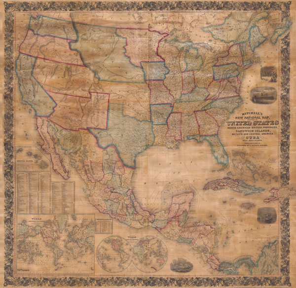
Mitchell's New National Map of the United States, North American British Provinces, Sandwich Islands, Mexico and Central America together with Cuba and other West India Islands.
1856 (dated) 60 x 60 in (152.4 x 152.4 cm)
1856 (dated) 60 x 60 in (152.4 x 152.4 cm)
Description
This is the first edition of Mitchell's important 1856 wall map of the United States, Mexico and the West Indies. Depictss the entire nation from Atlantic to Pacific with inset maps of the World on Mercator's Projection and the World on Globular Projection, and Hawaii (The Sandwich Islands). In his important book on Mapping the Transmississippi West 1540-1861 , Wheat calls this map an 'achievement' and describes it's western portion in considerable detail. This wall map includes the territory acquired following the Mexican American war and was one of the best depictions of the Western U.S. to appear in the 1850s. The map includes the 1854 Gadsden Purchase in Texas, the 1855 Mexico / United States border, and detailed information derived from Stansburys 1852 study of the region. A seminal map and a must for any serious United States, Southwest or Trans-Mississippi map collection.
Cartographer
Samuel Augustus Mitchell (March 20, 1792 - December 20, 1868) began his map publishing career in the early 1830s. Mitchell was born in Bristol, Connecticut. He relocated to Philadelphia in 1821. Having worked as a school teacher and a geographical writer, Mitchell was frustrated with the low quality and inaccuracy of school texts of the period. His first maps were an attempt to rectify this problem. In the next 20 years Mitchell would become the most prominent American map publisher of the mid-19th century. Mitchell worked with prominent engravers J. H. Young, H. S. Tanner, and H. N. Burroughs before attaining the full copyright on his maps in 1847. In 1849 Mitchell either partnered with or sold his plates to Thomas, Cowperthwait and Company who continued to publish the Mitchell's Universal Atlas. By about 1856 most of the Mitchell plates and copyrights were acquired by Charles Desilver who continued to publish the maps, many with modified borders and color schemes, until Mitchell's son, Samuel Augustus Mitchell Junior, entered the picture. In 1859, S.A. Mitchell Jr. purchased most of the plates back from Desilver and introduced his own floral motif border. From 1860 on, he published his own editions of the New General Atlas. The younger Mitchell became as prominent as his father, publishing maps and atlases until 1887, when most of the copyrights were again sold and the Mitchell firm closed its doors for the final time. More by this mapmaker...
Condition
Expertly repaired, backed with modern linen, trimmed in maroon cloth, on original wooden rollers.
References
Wheat, Carl Irving, Mapping the Transmississippi West, 1540-1861 (5 vols), page 731.