This item has been sold, but you can get on the Waitlist to be notified if another example becomes available, or purchase a digital scan.
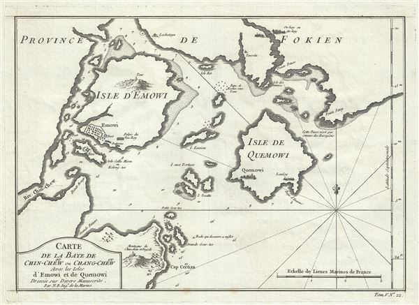
1764 Bellin Map of Amoy (Xiamen) and Fokien (Fujian), China
Amoy-bellin-1764$87.50

Title
Carte de la Baye de ou Chin-Chew ou Chang-Chew Avec les Isles D'Emowi et de Quemowi.
1764 (undated) 9 x 12.5 in (22.86 x 31.75 cm) 1 : 150000
1764 (undated) 9 x 12.5 in (22.86 x 31.75 cm) 1 : 150000
Description
A scarce c. 1764 Nicholas Bellin nautical chart or maritime map of the Bay of Changchow (Zhangzhou), Fujian, China. The map focuses on the city of Amoy (here spelled Emowi), or modern day Xiamen. Being primarily a nautical chart, the map offers limited inland detail, but the city of Amoy (Xiamen), as well as adjacent points of interest including fortifications, palaces, pagodas, and nearby cities, are rendered pictorially. On the island itself a large mountain, most likely Xianyue Mountain, with a tower, is depicted. Xiamen or Amoy was a place of exceptional interest to European traders as China's main port for the export of tea. Later, in the 19th century, it became one of several 'Treaty Ports' open to foreign traders. Today Xiamen is considered China's 'most romantic city.' This map is very similar to another map published by Bellin and Van Schley, however features a different cartouche and is printed on thicker paper.
Cartographer
Jacques-Nicolas Bellin (1703 - March 21, 1772) was one of the most important cartographers of the 18th century. With a career spanning some 50 years, Bellin is best understood as geographe de cabinet and transitional mapmaker spanning the gap between 18th and early-19th century cartographic styles. His long career as Hydrographer and Ingénieur Hydrographe at the French Dépôt des cartes et plans de la Marine resulted in hundreds of high quality nautical charts of practically everywhere in the world. A true child of the Enlightenment Era, Bellin's work focuses on function and accuracy tending in the process to be less decorative than the earlier 17th and 18th century cartographic work. Unlike many of his contemporaries, Bellin was always careful to cite his references and his scholarly corpus consists of over 1400 articles on geography prepared for Diderot's Encyclopedie. Bellin, despite his extraordinary success, may not have enjoyed his work, which is described as "long, unpleasant, and hard." In addition to numerous maps and charts published during his lifetime, many of Bellin's maps were updated (or not) and published posthumously. He was succeeded as Ingénieur Hydrographe by his student, also a prolific and influential cartographer, Rigobert Bonne. More by this mapmaker...
Condition
Very good. Wide clean margins. Original platemark visible. Blank on verso.