1846 British Admiralty Nautical Chart or Map of Xiamen (Amoy), China
AmoyHarbor-admiralty-1846$950.00

Title
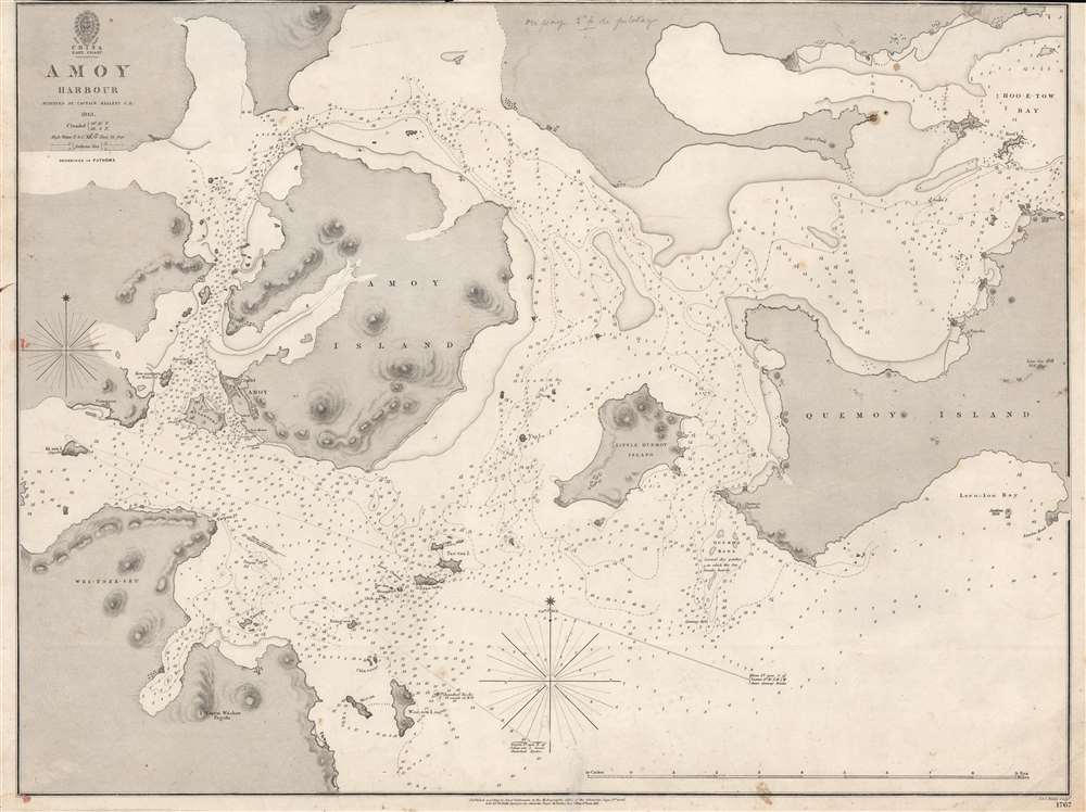
Amoy Harbour.
1846 (dated) 18.75 x 24.675 in (47.625 x 62.6745 cm) 1 : 75000
1846 (dated) 18.75 x 24.675 in (47.625 x 62.6745 cm) 1 : 75000
Description
This is an 1846 British Admiralty nautical chart or maritime map of Amoy (Xiamen / 厦门市), China, one of the treaty ports created by the Treaty of Nanking. It was published shortly after the First Opium War (1839 - 1842) and the signing of the Treaty of Nanking. This chart is the result of the important survey work that followed in the wake of the Opium Wars and the opening of wide-scale trade with China. It provided the bases of British maritime trade in and around Amoy for the subsequent 2 decades.
In 1839, the Daoguang Emperor, seeking to stem the tide of narcotic addiction, banned opium entirely and blockaded China's only open trade port - Canton (Guangzhou). They also seized and destroyed nearly 20,000 chests, roughly 1,200 tons, of opium. Foreign traders within Canton were confined to their offices without access to outside food or supplies - essentially forcing a 'capitulate or starve' situation.
The British subsequently dispatched a naval and military force. The Royal Navy used its cannon to inflict a series of decisive defeats on the Qing at various ports, forcing them to the negotiating table - a tactic later referred to as 'gunboat diplomacy.' By 1842, the Qing were forced to sign the Treaty of Nanking, the first of the Unequal Treaties. The Treaty of Nanking created five open treaty ports (Shanghai, Canton (Guangzhou), Ningpo (Ningbo), Foochow (Fuzhou), and Amoy (Xiamen)) and ceded Hong Kong to the British Empire. The Opium trade quickly resumed, but escalating tensions led to the Second Opium War (1856 - 1860) just fourteen years later in 1856.
A Closer Look
Amoy (Xiamen), with its citadel, appears on the southwestern side of Amoy Island, across a strait from Kulangseu. Innumerable depth soundings populate the waters, providing mariners with valuable nautical data. Numerous smaller islands are illustrated, along with Quemoy Island on the right.The First Opium War
The First Opium War (1839 - 1842), also known as the Anglo-Chinese War, was a series of engagements fought between the United Kingdom and Qing China over trade and diplomatic relations. By the middle of the 19th century, an enormous trade imbalance had developed between Europe and China due to a high demand for Chinese goods (silk, porcelain, tea) in Europe and a low demand for European goods (English wool anyone?) in China. To balance the trade, the British East India Company introduced Indian-grown opium. The opium trade led to waves of addiction throughout China and reversed the trade imbalance within a couple of years.In 1839, the Daoguang Emperor, seeking to stem the tide of narcotic addiction, banned opium entirely and blockaded China's only open trade port - Canton (Guangzhou). They also seized and destroyed nearly 20,000 chests, roughly 1,200 tons, of opium. Foreign traders within Canton were confined to their offices without access to outside food or supplies - essentially forcing a 'capitulate or starve' situation.
The British subsequently dispatched a naval and military force. The Royal Navy used its cannon to inflict a series of decisive defeats on the Qing at various ports, forcing them to the negotiating table - a tactic later referred to as 'gunboat diplomacy.' By 1842, the Qing were forced to sign the Treaty of Nanking, the first of the Unequal Treaties. The Treaty of Nanking created five open treaty ports (Shanghai, Canton (Guangzhou), Ningpo (Ningbo), Foochow (Fuzhou), and Amoy (Xiamen)) and ceded Hong Kong to the British Empire. The Opium trade quickly resumed, but escalating tensions led to the Second Opium War (1856 - 1860) just fourteen years later in 1856.
Publication History and Census
This map was created by the Hydrographic Office of the British Admiralty from surveys completed by Captain Henry Kellett in 1843, engraved by J. and C. Walker, and published by the Admiralty in 1846. We note a single cataloged example, located at the National Maritime Museum, Greenwich, London.CartographerS
The British Admiralty Office (1795 - Present) or the United Kingdom Hydrographic Office refers to the Branch of the English government that is responsible for the command of the British Navy. In 1795 King George III created the United Kingdom Hydrographic Office, known in short as the U.K.H.O., to provide top notch nautical charts to the vast Royal Navy. Prior the founding of the Admiralty the surveying and creation of nautical charts was primarily a commercial venture wherein the cartographer himself, more of than not, actually financed the printing of his own material. The great navigator Cook himself is known to have scrambled for funds to publish his own seminal charts - the most important and advanced of the period. The system of privately funded nautical mapping and publishing left vast portions of the world uncharted and many excellent charts unpublished. King George III, responding significant loss in trade revenue related to shipwrecks and delay due to poor charts, recognized the need for an institutionalized government sponsored cartographic agency - the Admiralty. The first head of the Admiralty, a position known as Hydrographer, was the important cartographer Alexander Dalrymple. Dalrymple started by organizing and cataloging obtainable charts before initiating the laborious process of updating them and filling in the blanks. The first official Admiralty Chart appeared in 1800 and detailed Quiberon Bay in Brittany. By 1808 the position of Hydrographer fell to Captain Thomas Hurd. Hurd advocated the sale of Admiralty charts to the general public and, by the time he retired in 1829, had issued and published some 736 charts. Stewardship of the organization then passed to Rear Admiral Sir Francis Beaufort. It was under Beaufort's administration that the Admiralty truly developed as a "chart making" as opposed to a "chart cataloging" institution. Beaufort held his post from 1829 to 1854. In his 25 years at the Admiralty Beaufort created nearly 1500 new charts and sponsored countless surveying and scientific expeditions - including the 1831 to 1836 voyage of the H.M.S. Beagle. By 1855 the Admiralty's chart catalog listed some 1,981 charts. More by this mapmaker...
John Walker (1787 - April 19, 1873) was a British map seller, engraver, lithographer, hydrographer, geographer, draughtsman, and publisher active in London during the 19th century. Walker published both nautical charts and geographical maps. His nautical work is particularly distinguished as he was an official hydrographer for the British East India Company, a position, incidentally, also held by his father of the same name. Walker's maps, mostly published after 1827, were primarily produced with his brothers Charles Walker and Alexander Walker under the imprint J. and C. Walker. Among their joint projects are more than 200 maps for the influential Society for the Diffusion of Useful Knowledge Atlas (SDUK). In addition they published numerous charts for James Horsburgh and the British Admiralty Hydrographic Office, including Belcher's important map of Hong Kong and Carless' exploratory map of Karachi. The J. and C. Walker firm continued to publish after both Walkers died in the 1870s. Learn More...
Condition
Very good. Light soiling. Closed tear extending one-half (.5) inch into printed area from bottom margin professionally repaired on verso. Top margin trimmed to border.
References
National Maritime Museum Greenwich G272:2/25.