This item has been sold, but you can get on the Waitlist to be notified if another example becomes available, or purchase a digital scan.
1835 Bradford Map of the Ancient Cities of Athens, Rome, Jerusalem and the Sinai Peninsula
AncientCities-bradford-1835$50.00

Title
Athens. Rome. Jerusalem and Vicinity. Peninsula of Mt. Sinai.
1835 (undated) 10.5 x 8.5 in (26.67 x 21.59 cm)
1835 (undated) 10.5 x 8.5 in (26.67 x 21.59 cm)
Description
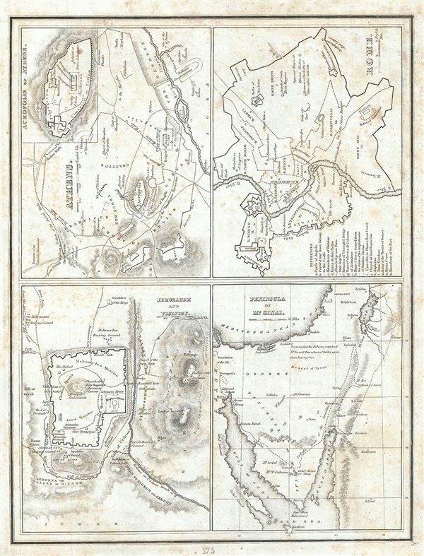
This is a scarce 1835 map or plan of the ancient cities of Athens (Greece), Rome (Italy), Jerusalem (Israel) and the Peninsula of Mt. Sinai (Egypt) by the important American mapmaker T. G. Bradford. Essentially four maps on a single sheet, each map is highly detailed and beautifully depicts the ancient regions.
Athens, capital of the Athenian empire, was the heart of Ancient Greek culture and the quintessential Ancient Greek city state. It was here that Greek philosophy and literature as well as the concept of democracy first evolved. This plan of Athens, based on excavations and ancient sources offers impressive and accurate detail. Depicts the ancient wall and its vestiges as well as the modern walls. Notes the ancient city's most important buildings and monuments, including the Temple of Theseus, the Stoa of Hadrian, theatre of Bacchus, etc. An inset in the top right quadrant of this map details the Acropolis of Athens.
The Map or plan of Rome depicts the 'Eternal City' in great detail. Known as the birthplace of western civilization, Rome was the capital of the Roman Empire. The map details the city within the modern wall, labeling important ancient buildings and sites including the Colosseum, Site of the Circus Maximus, the baths of Diodetian, the Pantheon and others. Vatican City is also included. A key identifying 15 ancient sites is included in the lower left quadrant.
The third plan depicts Jerusalem and its vicinity. Here too Bradford notes important ancient sites and monuments including the Sepulture of David, King's Pool, Mount Zion, Pillar of Absalom and others. The forth map depicts the Sinai Peninsula and notes the 'Probable route of the Israelites' as they fled out of Egypt, across the Red Sea, and subsequently spent the next forty years wandering in the Sinai before migrating into the Promised Land by crossing the Jordan River just north of the Dead Sea.
The map was published as plate no. 175 in Thomas G. Bradford's 1835 Comprehensive Atlas Geographical, Historical and Commercial. Bradford's atlas, published in 1835 was an important work on many levels. First, it was one of the first American atlases to follow an encyclopedic format, offering readers extensive geographical and statistical tables to supplement the maps themselves. Second, it was published in Boston and influenced the city's rise as a publishing center later in the 19th century (at the time most publishing in the United States was restricted to New York and Philadelphia). Third, this atlas was the first to contain a separate and specific map showing the Republic of Texas. Fourth and finally, Bradford's atlas in some instances broke the Euro-centric mold regarding atlas production. Among other things, Bradford focused his atlas on the Americas and abandoned the classical decoration common in European atlases in favor of a more informational and inherently American approach.
Bradford published this atlas in several editions and with various partners. The first edition was published by William D. Ticktor and did not contain the iconic Republic of Texas map (although we have in fact seen Ticktor examples with a Texas map, suggesting, against conventional wisdom, that there may have been two Ticktor editions). The second official edition, published in the same year by the American Stationers Company, was the first to contain the Republic of Texas map, which is based on Austin's map, with two pages of descriptive text. A third edition was issued in 1836, also by American Stationers (though still dated 1835), and contained an unaltered Republic of Texas map with only a single page of descriptive text. A fourth edition appeared later, possibly 1837, and included an updated and revised map of Texas that replaces the old Mexican land grants with new inchoate counties. The maps from this atlas are an important addition to any collection focusing on early American cartography and Republic of Texas cartography.
All maps in this atlas, though not specifically noted as such, were most likely engraved by G. W. Boynton of Boston, who also engraved most of the maps for Bradford's later publication.
CartographerS
Thomas Gamaliel Bradford (1802 - 1887) was born in Boston, Massachusetts, where he worked as an assistant editor for the Encyclopedia Americana. Bradford's first major cartographic work was his revision and subsequent republishing of an important French geography by Adrian Balbi, Abrege de Geographie published in America as Atlas Designed to Illustrate the Abridgment of Universal Geography, Modern and Ancient. Afterwards Bradford revised and expanded this work into his own important contributions to American cartography, the 1838 An Illustrated Atlas Geographical, Statistical and Historical of the United States and Adjacent Countries. Bradford's cartographic work is significant as among the first to record Texas as an independent nation. In his long career as a map publisher Bradford worked with William Davis Ticknor of Boston, Freeman Hunt of New York, Charles De Silver of Philadelphia, John Hinton, George Washington Boynton, and others. We have been able to discover little of Bradford's personal life. More by this mapmaker...
George Washington Boynton (fl. c. 1830 - 1850) was a Boston based cartographer and map engraver active in the first half of the 19th century. Boynton engraved and compiled maps for numerous publishers including Thomas Bradford, Nathaniel Dearborn, Daniel Adams, and S. G. Goodrich. His most significant work is most likely his engraving of various maps for Bradford's Illustrated Atlas, Geographical, Statistical, and Historical, of the United States and the Adjacent Countries and Universal Illustrated Atlas. He also engraved for the Boston Almanac. In 1835, Boynton is listed as an employee of the Boston Bewick Company, an engraving, stereotype, and printing concern based at no. 47 Court Street, Boston. Little else is known of his life. Learn More...
Source
Bradford, T. G., A Comprehensive Atlas Geographical, Historical and Commercial (Boston), 1835.
Condition
Very good. Original platemark visible. Minor spotting at places. Blank on verso.
References
Rumsey 2643.184 (1838 edition).