1831 S.D.U.K. Map of Ancient Egypt
AncientEgypt-sduk-1844$150.00

Title
Ancient Egypt.
1831 (dated) 15.5 x 13 in (39.37 x 33.02 cm) 1 : 2700000
1831 (dated) 15.5 x 13 in (39.37 x 33.02 cm) 1 : 2700000
Description
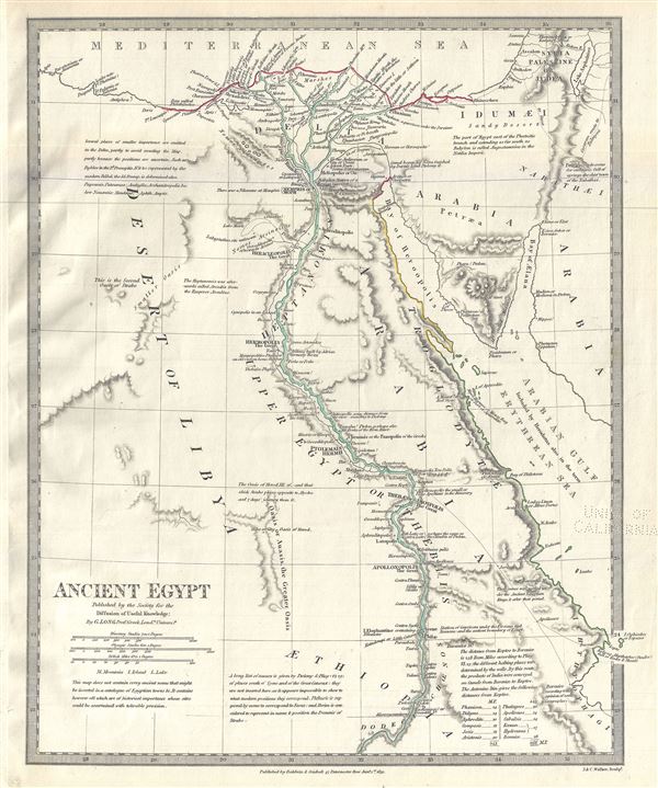
This is a fascinating and beautiful 1831 example of the Society for the Diffusion of Useful Knowledge or S.D.U.K. map of ancient Egypt. Centered on the Nile River Delta, the map covers Egypt and the Sinai Peninsula and part of Arabia and the Red Sea. Several ancient towns and oases along the Nile are noted. The map also contains numerous interesting cartographic annotations. Several notes are included throughout regarding the absence of ancient places and names mentioned on the map. Possibly this map's most interesting aspect is its speculative presentation of the ancient Lake Moeris, now just a small lake called Birket Qarun, and the legendary 'Labyrinthus site unknown'' near modern day Hawara. The lost Labyrinth was described by many classical authors including Herodotus, Strabo, Diodorus and Pliny. A sprawling megalithic complex designed by Imandes for the Pharaoh Amenemhet III, the Labyrinth is believed to have contained thousands of rooms filled with hieroglyphs and ancient Egyptian sculptures. Herodotus wrote about it in the fifth century B.C.:
This map was originally published by Baldwin and Cradock and copyrighted in 1831, but was issued in Volume two of Chapman and Hall's 1844 edition of Maps of the Society for the Diffusion of Useful Knowledge. It was engraved by John Walker of J. and C. Walker.
Furthermore, they resolved to leave a memorial of themselves in common, and in pursuance of this resolve they made a labyrinth, a little above Lake Moeris, and situated near what is called the City of the Crocodiles. I saw it myself and it is indeed a wonder past words; for if one were to collect together all of the buildings of the Greeks and their most striking works of architecture, they would all clearly be shown to have cost less labor and money than this labyrinth. Yet the temple at Ephesus and that in Samos are surely remarkable. The pyramids, too, were greater than words can tell, and each of them is the equivalent of many of the great works of the Greeks; but the labyrinth surpasses the pyramids also. It has 12 roofed courts, with doors facing one another, 6 to the north and 6 to the south and in a continuous line. There are double sets of chambers in it, some underground and some above, and their number is 3,000; there are 1,500 of each. We ourselves saw the aboveground chambers, for we went through them so we can talk of them, but the underground chambers we can speak of only from hearsay. For the officials of the Egyptians entirely refused to show us these, saying that there were, in them, the coffins of the kings who had built the labyrinth at the beginning and also those of the holy crocodiles. So we speak from hearsay of these underground places; but what we saw aboveground was certainly greater than all human works. The passages through the rooms and the winding goings-in and out through the courts, in their extreme complication, caused us countless marvelings as we went through, from the court into the rooms, and from the rooms into the pillared corridors, and then from these corridors into other rooms again, and from the rooms into other courts afterwards. The roof of the whole is stone, as the walls are, and the walls are full of engraved figures, and each court is set round with pillars of white stone, very exactly fitted. At the corner where the labyrinth ends there is, nearby, a pyramid 240 feet high and engraved with great animals. The road to this is made underground.Several archeological surveys have been undertaken to unearth the labyrinth, but so far no findings have been confirmed.
Such was the labyrinth; but an even greater marvel is what is called Lake Moeris, beside which the labyrinth was built. The circuit of this lake is a distance of about 420 miles, which is equal to the whole seaboard of Egypt. The length of the lake is north and south, and its depth at the deepest is 50 fathoms [300 feet]. That it is handmade and dug, it itself is the best evidence. For in about the middle of the lake stand 2 pyramids that top the water, each one by 50 fathoms [300 feet], and each built as much again underwater; and on top of each there is a huge stone figure of a man sitting on a throne. So these pyramids are 100 fathoms [600 feet] high, and these 100 fathoms are the equivalent of a 600-foot furlong, the fathom measuring 6 feet, or four cubits (the cubit being six spans). The water in the lake is not fed with natural springs, for the country here is terribly waterless, but it enters the lake from the Nile by a channel; and for 6 months it flows into the lake, and then, another 6, it flows again into the Nile. During the 6 months that it flows out, it brings into the royal treasury each day a silver talent for the fish from it; and when the water flows in, it brings 20 minas a day.
This map was originally published by Baldwin and Cradock and copyrighted in 1831, but was issued in Volume two of Chapman and Hall's 1844 edition of Maps of the Society for the Diffusion of Useful Knowledge. It was engraved by John Walker of J. and C. Walker.
CartographerS
The "Society for the Diffusion of Useful Knowledge" (1826 - 1848) was a Whiggish organization founded in 1828 at the instigation of idealistic British lord Henry Peter Brougham. The admirable goal of the Society was to distribute useful information via a series of publications to the English working and middle classes. It promoted self-education and the egalitarian sharing of all knowledge. While closely tied to the London University and publishing houses on the order of Baldwin and Cradock, Chapman and Hall, and Charles Knight, the Society failed to achieve its many lofty goals in finally closed its doors in 1848. Most likely the failure of the Society resulted from its publications being too expensive for its intended lower to middle class markets and yet not large and fine enough to appeal to the aristocratic market. Nonetheless, it did manage to publish several extraordinary atlases of impressive detail and sophistication. Their most prominent atlas consisted of some 200 separately issued maps initially published by Baldwin and Cradock and sold by subscription from 1829 to 1844. Afterwards, the Society combined the maps into a single world atlas published under the Chapman and Hall imprint. In its day, this atlas was unprecedented in its quality, scope, and cost effectiveness. Today Society, or S.D.U.K. as it is commonly known, maps are among the most impressive examples of mid-19th century English mass market cartographic publishing available. The S.D.U.K. is especially known for its beautiful and accurately detailed city plans. More by this mapmaker...
Chapman and Hall (fl. 1830 - present) was a British publishing house in London, founded in 1830 by Edward Chapman and William Hall. Upon Hall's death in 1847, Chapman's cousin Frederic Chapman became partner in the company, of which he became sole manager upon the retirement of Edward Chapman in 1864. In 1868 author Anthony Trollope bought a third of the company for his son, Henry Merivale Trollope. From 1902 to 1930 the company's managing director was Arthur Waugh. In the 1930s the company merged with Methuen, a merger which, in 1955 participated in forming the Associated Book Publishers. The latter was acquired by The Thomson Corporation in 1987. Chapman and Hall was sold again in 1998 as part of Thomson Scientific and Professional to Wolters Kluwer, who sold on its well-regarded mathematics and statistics list to CRC Press. Today the name of Chapman and Hall/CRC is used as an imprint for science and technology books by Taylor and Francis, part of the Informa group since 2004. The company is best known for its publication of the works of Charles Dickens (from 1840 until 1844 and again from 1858 until 1870), William Thackeray, Elizabeth Barrett Browning, Eadweard Muybridge and Evelyn Waugh. They continued to publish hitherto unpublished Dickens material well into the 20th century. In cartographic circles they are known as the primary publishers of the Society for the Diffusion of Useful Knowledge Atlas, a massive 200+ map atlas that was popular in England during the mid-19th century. Learn More...
John Walker (1787 - April 19, 1873) was a British map seller, engraver, lithographer, hydrographer, geographer, draughtsman, and publisher active in London during the 19th century. Walker published both nautical charts and geographical maps. His nautical work is particularly distinguished as he was an official hydrographer for the British East India Company, a position, incidentally, also held by his father of the same name. Walker's maps, mostly published after 1827, were primarily produced with his brothers Charles Walker and Alexander Walker under the imprint J. and C. Walker. Among their joint projects are more than 200 maps for the influential Society for the Diffusion of Useful Knowledge Atlas (SDUK). In addition they published numerous charts for James Horsburgh and the British Admiralty Hydrographic Office, including Belcher's important map of Hong Kong and Carless' exploratory map of Karachi. The J. and C. Walker firm continued to publish after both Walkers died in the 1870s. Learn More...
Source
Maps of the Society for the Diffusion of Useful Knowledge, (London: Chapman and Hall)
The Society for the Diffusion of Useful Knowledge (S.D.U.K.) Atlas was initially issued in parts over several years by Baldwin and Craddock to promote the society's mission of egalitarian self-education. The first S.D.U.K. began appearing in 1829 when the society contracted John Walker to produce the first proofs. The first S.D.U.K maps were produced serially by Baldwin and Craddock and issued in 2 map batches, priced at 2 shillings each. The series, originally anticipated to feature 50 maps, ultimately contained 200 and took over 14 years to produce. The initial production was completed in 1844 when the whole was issued in its first compiled atlas edition. Around 1842, following the 1837 bankruptcy of Baldwin and Craddock, publication of the atlas was taken over by the Society itself, who issued editions in 1838, 1839, 1840, 1841, and 1842. Overburdened by the work of publishing, they then outsourced the publication to Chapman and Hall in 1842. Chapman and Hall produced editions in 1842, 1843, and 1844. Dissatisfied with the quality of Chapman and Hall printing, the Society turned to another publisher, Charles Knight, who issued editions under the auspices of the Society in 1844, 1845, and 1846. In 1846 Knight officially acquired the plates in his own right and reissued in revised editions until 1852, when he sold them to George Cox. Cox in turn sold them to Edward Stanford who published them from 1856 well into the 1860s. The S.D.U.K. Atlas is known for the quantity and quality of its maps. The S.D.U.K. published many maps of areas largely ignored by other publishers. The many city plans incorporated into the atlas are particularly admired and are the highlight of the S.D.U.K.'s long map publishing history. As a whole the S.D.U.K. Atlas was groundbreaking in terms of quality, scope, and being offer at a cost effective price point.
Condition
Very good. Bears University of California Library Stamp, from which it was deaccessioned, in lower right quadrant. Blank on verso.
References
Rumsey 0890.120. Phillips (Atlases) 794.