This item has been sold, but you can get on the Waitlist to be notified if another example becomes available, or purchase a digital scan.
1831 Dower / Teesdale Map of the Holy Land
AncientPalestine-dower-1831$200.00

Title
Ancient Palestine.
1831 (dated) 15.5 x 12.5 in (39.37 x 31.75 cm) 1 : 990000
1831 (dated) 15.5 x 12.5 in (39.37 x 31.75 cm) 1 : 990000
Description
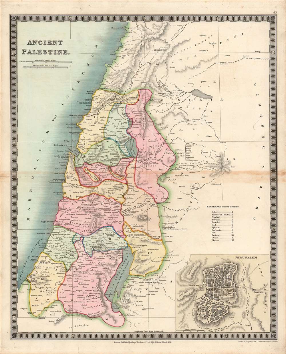
Here is Henry Teesdale / John Dower's 1831 map of the Holy Land as it appeared in ancient times, published in A New General Atlas of the World. It illustrates the location of the Twelve Tribes of Ancient Israel, as discussed in the Bible, in particular the Book of Joshua.
A Closer Look
This beautifully engraved and hand-colored map highlights the location of the Twelve Tribes of Israel on lands delegated to them by Joshua, the leader of the Israelites following Moses, who led them to conquer Canaan. As the definition of tribes themselves and the territory they controlled is somewhat vague in the Bible, and changed over time in any case, the cartographer had some creative license, and therefore this map differs from other contemporaneous maps of the Holy Land in ancient times (such as Smiley's 1834 map (HolyLand-smiley-1834), Seaton's 1835 map (HolyLand-seaton-1835), and Beiling's 1843 map Palastina-beiling-1843)). This map is also distinct for its use of Olympic stadia for scale and Latin names for places and features. At bottom-right is an inset map of Jerusalem (again using Latin terminology, such as 'Mons Moriah Templum' for the Temple Mount).Publication History and Census
This map was engraved by John Dower for the 1831 edition of A New General Atlas of the World, published by Henry Teesdale. This appears to be an especially rare presentation of this map, as examples in the David Rumsey Historical Map Collection and other major digital repositories from other editions of the map do not show such vivid and full color, only hand-colored outlines of territories. The 1831 edition of this map is only independently cataloged in the holdings of three institutions, while the entire atlas is held by roughly a dozen institutions, though as stated above the present map is likely distinct from those examples in coloration.CartographerS
John James Dower (June 1, 1825 - 1901) was a well-respected mapmaker, print seller, and publisher based in London, England. Dower is the heir to the more prominent London engraver and mapmaker John Crane Dower (1791 - 1847). Dower worked with many prominent middle to late 19th century London map publishers including Weller, Cassell, Bacon, Petermann, and others. He was elected to the Royal Geographical Society in 1854. Dower also published on maps his own account including one atlas and various school geographies. In addition to his cartographic work, Dower is well known as an engraver of military scenes. More by this mapmaker...
Henry Teesdale (December 1776 - January 1856) was a British map publisher active in the first half of the 19th century. Teesdale was born in London. He was elected to the Royal Geographical Society in 1830. Teesdale initially partnered with John Hordan and William Colling Hobson as Henry Teesdale and Company, but this partnership was dissolved in 1832. Afterwards Teesdale continued to publish maps and atlases on his own account. He worked with several major British map engravers of the period including John Crane Dower, Christopher Greenwood, and Josiah Henshall, among others. His most prominent work is a large map of the world engraved by Dower. He must have enjoyed considerable commercial success because in 1845 he is registered as a partner in the Royal Bank of Scotland. Teesdale died in January of 1856 and was buried in All Souls, Kensal Green. Learn More...
Source
Dower, John, A New General Atlas of the World, (London: Teesdale) 1831.
Condition
Good. Toning and some wear along the central fold line.
References
OCLC 43213353.