This item has been sold, but you can get on the Waitlist to be notified if another example becomes available, or purchase a digital scan.
1867 Hughes Map of Ancient Cities and Battlegrounds
AncientTopo-hughes-1867$50.00

Title
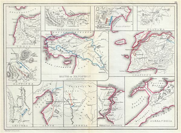
Troja. Thermopylae. Marathon. Plataea. Mantinea. Leuctra. Route of Xenophon and the Ten Thousand Greeks. Granicus. Issus. Arbela. Thracian Bosporus. Alexandria.
1867 (undated) 10 x 13 in (25.4 x 33.02 cm)
1867 (undated) 10 x 13 in (25.4 x 33.02 cm)
Description
This is a fascinating 1867 map by William Hughes featuring topographical maps of ancient cities and battle sites. The map essentially contains twelve maps on a single sheet, each focusing on a different city or town, where important ancient battles took place. Beginning from the map on the top left, moving clockwise, these include Troy (Troja), Thermopylae, Marathon, Plataea, Granicus, Alexandria, Thracian Bosporus, Erbil (Arbela), Issus, Leuctra and Mantinea. Some of the maps are color coded to show the two sides in battle. The map in the center features the Route of Xenophon and the Ten Thousand Greeks.
From 401 BC and 399 BC, a group of ten thousand Greek mercenaries marched to the battle of Cunaxa (Connaxa). The mercenaries, brought together by Cyrus the Younger, hoped to unseat the Persian king Artaxerxes II in favor of Cyrus. The Greeks marched from the Aegean coast inland as far as Mesopotamia where the forces of Artaxerxes II were crushed. The military victory however, proved pointless as Cyrus himself had been slain. Xenophon, one of their leaders, recorded the expedition in his book Anabasis, which would later be used by Alexander the Great during his early missions into Persia.
The map on the top left features Troy, the ancient city located in northwest Turkey, most famous for being the location of the Trojan War between the Archaeans and the city of Troy. Homer's Illiad and Odyssey describe the events of the War. Thermopylae, featured in the next map, was an ancient region in Greece known for the Battle of Thermopylae during the second Persian invasion of Greece. It was fought by an alliance of the Greek city-states, against the Persian Empire of Xerxes I. Marathon, featured in the next map, was witness to the Battle of Marathon in 490 BC, between the Athenians and Persian forces resulting in an Athenian victory.
Plataea is features in the map on the top right quadrant of the map. The battle of Plataea occurred here in 479 BC and was the last battle in the second Persian invasion of Greece. It was fought by an alliance of the Greek city-states, including Sparta, Athens, Corinth and Megara, against the Persian Empire of Xerxes I. The battle concluded with a large portion of the Persian army trapped in their camp where they were slaughtered, essentially brining the invasion to a close. The map of Granicus below it depicts the movements of Alexander the Great and the Persian Empire during the Battle of Granicus River. Fought on the road from Abydos (noted here) near the Granicus River, on whose banks Alexander the Great gained his first victory over Darius, thus gaining a huge portion of Asia Minor.
The map of Alexandria, featured in the lower right quadrant is highly detailed and notes important ancient buildings, including the gymnasium, the amphitheater, etc. Alexandria, founded by Alexander the Great on his way back from the Oasis and Temple of Jupiter Ammon, was one of the most important ancient cities. The Thracian Bosporus features in the next map, depicts the Bosphorus, a narrow naval passage from the Sea of Marmara to the Black Sea, The ancient city of Byzantium (modern day Istanbul) is also identified.
Arbela, or modern day Erbil or Irbil, depicted in the next map, was the scene of the battle between Alexander the Great and Darius III of Persia, which sealed the fate of Darius and the Persian monarchy. The map of Issus depicts the scene of the battle of Issus, where Alexander gained his second victory over the Persians, and made prisoners of war the wife, mother, and infant son of Darius. The map on the bottom left features Leuctra, a village in Boeotia. This map details the battle of Leuctra, fought in BC 371 between the Boeotians and the Spartans, part of the post-Peloponnesian War conflicts. It was during this battle that Epaminondas, commander of the Boeotian League, gained his first victory over the Lacedaemonians. The map of Mantinea depicts the scene of battle between the Thebans and the Spartans in 362 BC. The battle resulted in the second great victory of the Theban Epaminondas over the Lacedaemonians, and also the death of Epaminondas. The death of the victorious leader and the defeat of the Spartans led to the weakening of both the Spartans and the Thebans and eventually the rise of Macedonians in Greece.
This map was created by William Hughes, printed by J. Bien and engraved by G.E. Sherman, for issued as plate 26 in Sheldon and Company's An Atlas of Classical Geography.
CartographerS
William Hughes (c. 1818 - May 21, 1876) was a cartographer, engraver, lithographer, printer, and publisher active in London during the middle part of the 19th century. Hughes enjoyed and long and varied cartographic career. He was elected a Fellow of the Royal Geographical Society in 1838 and, from about 1840, taught geography and mapmaking at St. Johns College for Civil Engineers. He later taught the same at both Queens College and Kings College, London. For a time he was employed as a map librarian for the British Museum. Hughes began engraving maps around 1839 and worked with most of the prominent British map and atlas publishers of his era, including but not limited to Charles Knight, A. and C. Black, George Philip, William Cassell, and others. More by this mapmaker...
Julius (Julien) Bien (September 27, 1826 - December 21, 1909) was a German-Jewish lithographer and engraver based in New York City. Bien was born in Naumburg, Germany. He was educated at the Academy of Fine Arts, Cassell and at Städel's Institute, Frankfurt-am-Main. Following the suppression of the anti-autocratic German Revolutions of 1848, Bien, who participated in the pan-German movement, found himself out of favor in his home country and joined the mass German immigration to the United States. Bien can be found in New York as early as 1849. He established the New York Lithographing, Engraving & Printing Company in New York that focused on the emergent chromo-lithograph process - a method of printing color using lithographic plates. His work drew the attention of the U.S. Government Printing Office which contracted him to produce countless government maps and surveys, including the Pacific Railroad Surveys, the census, numerous coast surveys, and various maps relating to the American Civil War. Bien also issued several atlases both privately and in conjunction with a relation, Joseph Bien. At the height of his career Bien was elected president of the American Lithographers Association. After his death in 1909, Bien's firm was taken over by his son who promptly ran it into insolvency. The firm was sold to Sheldon Franklin, who, as part of the deal, retained the right to publish under the Julius Bien imprint. In addition to his work as a printer, Bien was active in the New York German Jewish community. He was director of the New York Hebrew Technical Institute, the New York Hebrew Orphan Asylum, and president of the B'nai B'rith Order. Learn More...
Sherman and Smith (fl. c. 1829 - 1855), sometimes working as Stiles, Sherman & Smith, were American engravers active in New York City during the middle part of the 19th century. The firm including John Calvin Smith (surveyor and engraver), George E. Sherman, and sometimes, Samuel Stiles. Their work primarily focused on government publications, including the maps and engravings prepared to illustrate the official records of the 1838-42 United States Exploring Expedition (U.S. Ex. Ex.), maps issued for the Army Corps of Topographical Engineers, and various U.S. Coast Survey Charts. They also engraved privately for Thomas Bradford and John Disturnell, among others. Sherman and Smith maintained offices at the corner of Broadway and Liberty Street in New York City and were highly regarded as the finest cartographic engravers in the city. Their non-cartographic legacies include George Inness, who apprenticed with them for two years before going on to become a well regarding American landscape painter of the Hudson River School. Learn More...
Source
Sheldon and Company, An Atlas of Classical Geography constructed by William Hughes and edited by George Long, (New York) 1867.
Condition
Very good. Minor wear and toning along original centerfold.