This item has been sold, but you can get on the Waitlist to be notified if another example becomes available, or purchase a digital scan.
1844 Black Map of the Ancient World and the Empire of Alexander the Great
AncientWorld-black-1844$62.50

Title
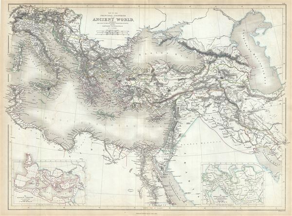
Map of the Principal Countries of the Ancient World extending from The Alps to the Southern Frontier of Egypt and from Carthage to Persepolis.
1843 (dated) 17 x 23 in (43.18 x 58.42 cm) 1 : 7100000
1843 (dated) 17 x 23 in (43.18 x 58.42 cm) 1 : 7100000
Description
This is a scarce example of Adam and Charles Black's 1844 map of the principal counties of the Ancient World. The map depicts part of the Empire of Alexander the Great and covers from modern day Italy south as far as Egypt and from Corsica to Caspian Sea. An inset map in the lower left quadrant depicts the Roman Empire at its height and another map in the lower right quadrant features the Persian Empire at its height, divided into its Satrapies. Various towns, cities, mountains, rivers, oases and several other topographical details are noted with relief shown by hachure.
Hughes engraved this map to illustrate the conquests of the Macedonian King Alexander III, called ‘the Great,' conqueror of the Persian Empire and at just thirty, ruler of one of the largest Empires in history. Alexander the Great was undefeated in battle and is considered one of the most successful military commanders of all time.
Founded by Cyrus the Great in the 6th century BCE, the First Persian Empire or the Achaemenid Empire was, at its height, the biggest Empire in the world. Cyrus appointed twenty Satraps or provincial administrators that ruled in the name of the king, thus making it possible to rule over the entire territory.
The Roman Empire was established in 27 BC after Gaius Julius Caesar Octavianus, the grandnephew and heir of Julius Caesar was awarded the honorific title of Augustus. During the time of the Empire, Roman cities flourished. Trade spread as far as India, Russia, China and Southeast Asia. However, the sheer size of the empire and its success also contributed to its downfall. The Western Roman Empire collapsed in AD 476, when Romulus Augustulus was deposed by the German Odovacer. The eastern Roman Empire, evolving into the Byzantine Empire, survived until the Ottoman Turks captured Constantinople in 1453.
This map was engraved by William Hughes and issued as plate no. LIX in the 1844 edition of i>Black's General Atlas.
CartographerS
Charles and Adam Black (fl. 1807 - present) were map and book publishers based in Edinburgh. Charles and his uncle, Adam, both of Edinburgh, Scotland, founded their publishing firm in 1807. They published a series of maps and atlases throughout the 19th century. In addition to an array of atlases, the Black firm is known for their editions of the Encyclopedia Britannica (1817 - 1826) and the first publishing of Sir Walter Scott's novels in 1854. In 1889 the A. & C. Black publishing house moved to London where it remains in operation to this day. More by this mapmaker...
William Hughes (c. 1818 - May 21, 1876) was a cartographer, engraver, lithographer, printer, and publisher active in London during the middle part of the 19th century. Hughes enjoyed and long and varied cartographic career. He was elected a Fellow of the Royal Geographical Society in 1838 and, from about 1840, taught geography and mapmaking at St. Johns College for Civil Engineers. He later taught the same at both Queens College and Kings College, London. For a time he was employed as a map librarian for the British Museum. Hughes began engraving maps around 1839 and worked with most of the prominent British map and atlas publishers of his era, including but not limited to Charles Knight, A. and C. Black, George Philip, William Cassell, and others. Learn More...
Source
Black, A. and C., Black's General Atlas (Edinburgh), 1844.
Black's General Atlas was a popular Scottish atlas of the world issued by the Edinburgh firm of Adam and Charles Black. This atlas was first issued in 1840 with subsequent editions being printed well into the 1890s. While most editions were printed in Edinburgh, an American edition was issued in 1857. Most early editions of his atlas were engraved by S. Hall. Typically this refers to Sidney Hall, who died in 1831, but in this case, since the engraving was initiated well after his death, it was most likely his widow, Selina Hall, who did the engraving. Later editions feature additional maps updated and engraved by William Hughes. Early editions featured outline color only, but later editions embraced a full color approach with pale green, yellow, and blue pastels. All editions are known for their meticulous presentation of the most up-to-date cartographic information. Moreover, this exceptionally long publication run provides a fine cartographic record of the middle to late 19th century - particularly as regards the complex cartographic evolution of the Americas through this period.
Condition
Very good. Original platemark visible. Blank on verso. Minor wear along original centerfold.
References
Rumsey 2305.071 (1854 edition). Philips (atlases) 4334.