This item has been sold, but you can get on the Waitlist to be notified if another example becomes available, or purchase a digital scan.
1707 De Fer Map of Grenada and Andalusia
Andalusia-fer-1707$375.00

Title
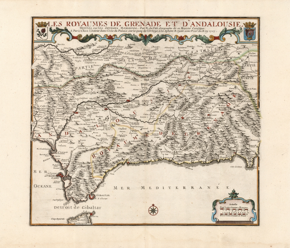
Les Royaumes de Grenade et d'Andalousie.
1707 (dated) 17.25 x 19 in (43.815 x 48.26 cm) 1 : 935000
1707 (dated) 17.25 x 19 in (43.815 x 48.26 cm) 1 : 935000
Description
This is a large, elegant map of Grenada and Andalusia in southern Spain produced in 1707 by Nicolas De Fer, in a lovely original color example. The map was produced during the War of Spanish Succession (1701 - 1714), of which the region here depicted was one of the many theatres. Cadiz and Málaga, in particular, saw major fleet actions in 1702 and 1704, respectively.It encompasses from the Strait of Gibraltar in the south to Guadiana River in the north. Cities are marked, pictorially indicating differences in size and importance. Among its chief cities are Cadiz, Seville, Écija, Córdoba, Jaén, Grenada, and the ports of Málaga, Almeria, and Gibraltar. The title at top is set off with an elegant strapwork border and is flanked with the arms of the Kingdoms of Granada and Andalusia.
Publication History and Census
This map was engraved in and around 1707 as a separate issue until the 1709 publication of the De Fer Atlas ou Recueil de Cartes and thereafter appeared in the De Fer atlas. We are aware of only one state of this map. It is scarce. Only twelve copies are listed in OCLC.Cartographer
Nicholas de Fer (1646 - October 25, 1720) was a French cartographer and publisher, the son of cartographer Antoine de Fer. He apprenticed with the Paris engraver Louis Spirinx, producing his first map, of the Canal du Midi, at 23. When his father died in June of 1673 he took over the family engraving business and established himself on Quai de L'Horloge, Paris, as an engraver, cartographer, and map publisher. De Fer was a prolific cartographer with over 600 maps and atlases to his credit. De Fer's work, though replete with geographical errors, earned a large following because of its considerable decorative appeal. In the late 17th century, De Fer's fame culminated in his appointment as Geographe de le Dauphin, a position that offered him unprecedented access to the most up to date cartographic information. This was a partner position to another simultaneously held by the more scientific geographer Guillaume De L'Isle, Premier Geograph de Roi. Despite very different cartographic approaches, De L'Isle and De Fer seem to have stepped carefully around one another and were rarely publicly at odds. Upon his death of old age in 1720, Nicolas was succeeded by two of his sons-in-law, who also happened to be brothers, Guillaume Danet (who had married his daughter Marguerite-Geneviève De Fer), and Jacques-François Bénard (Besnard) Danet (husband of Marie-Anne De Fer), and their heirs, who continued to publish under the De Fer imprint until about 1760. It is of note that part of the De Fer legacy also passed to the engraver Remi Rircher, who married De Fer's third daughter, but Richer had little interest in the business and sold his share to the Danet brothers in 1721. More by this mapmaker...
Source
De Fer, N., Atlas ou Recueil de Cartes, (Paris) 1709.
Condition
Excellent. Few faint spots, mainly in margins away from image. Else fine with elegant original hand color.
References
OCLC 1061953168. Rumsey 10022.074. Pastoureau, M., Les atlas Français XVIe-XVIIe siècles number 69 in entry FER IIC.