This item has been sold, but you can get on the Waitlist to be notified if another example becomes available, or purchase a digital scan.
1825 Basire Map of Anegada Island, Virgin Islands (w/ slave ship wrecks)
AnegadaVirginIslands-noyce-1825$1,250.00

Title
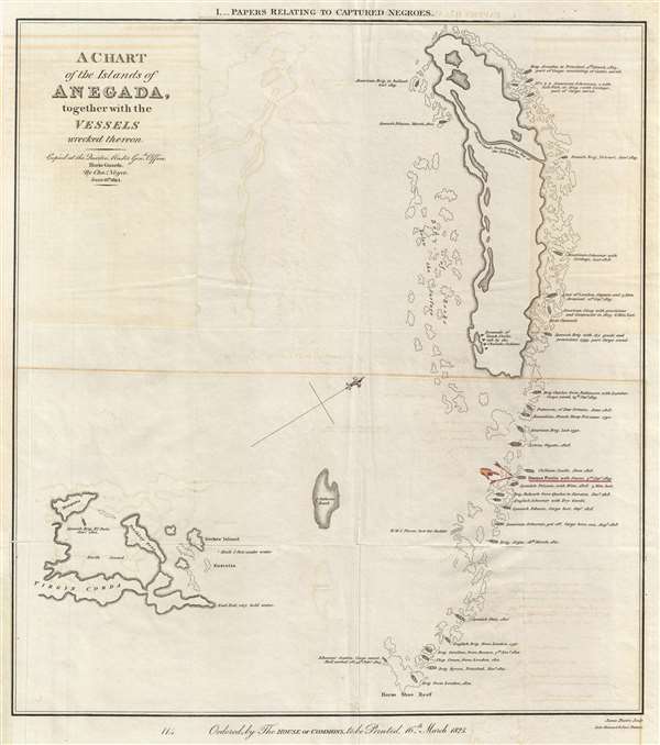
A Chart of the Island of Anegada, together with the Vessels wrecked thereon.
1825 (dated) 16.5 x 14.5 in (41.91 x 36.83 cm) 1 : 82000
1825 (dated) 16.5 x 14.5 in (41.91 x 36.83 cm) 1 : 82000
Description
This is a rare 1825 map of Anegada Island, the northernmost of the British Virgin Islands, illustrating shipwrecks occurring between 1799 and 1823. This map was specifically prepared to illustrate the wreck of the Donna Paula, which is highlighted in red, a slave ship that ran aground on the reefs south of Anegada on September 3, 1819. Also of note, the map includes a reasonably large-scale mapping of Necker Island, personal paradise of the British Billionaire Richard Branson.
The 1819 wreck of the Donna Paula, a Portuguese Salve Ship, identified in red here, led to a legislative battle in Great Britain, of which Anegada was a colony. Under British law, if a slave ship ran aground on British territory, where slavery was illegal, any surviving slaves, in this case some 240, would be recognized as free men. That did not happen in the case of the Donna Paula, instead, the two ships that rescued the survivors of the Donna Paula, including the 240 slaves, sailed to Porto Rico, where the slaves were subsequently sold as salvage. This map was prepared for the legislative struggle that ensued to ensure that in future incidents British laws on these islands would be respected.
In addition, some 30 other wrecks are illustrated highlighted just how dangerous the Anegada reefs are. Unlike the other Virgin Islands, Anegada is composed entirely of coral reefs which extend all around the island and well to the south of it, making any approach extremely hazardous. Although once popular for divers and wreck hunters, the size and fragile nature of the reef has since caused the government to forbid anchorage anywhere on the Anegada Reef.
This map was issued for the House of Commons on March 16, 1825, based upon a manuscript original that was copied Charles Noyce, of the Horse Guards, on June 16, 1824. It was published in a volume entitled Papers Relating to Captured Negroes. The map was engraved by James Basire and printed by Luke Hansard and Sons, London. This map is rare, with the OCLC identifying only 3 examples.
CartographerS
James Basire IV (March 1796 – May 17, 1869) was an English engraver and lithographer active in London during the early to middle 19th century. James Basire was the fourth engraver of that name in a family dynasty dating to 1704. Much of Basire's business focused on the printing of maps and diagrams for parliamentary reports. Basire IV it notable for is disdain for steel engraving in favor of copper. In addition to engraving, he invested in a brick-making business that apparently went poorly leading to several bankruptcies between 1847 and 1853. His son, also James Basire V, apprenticed to him in 1836, but the family engraving business was lost in bankruptcy proceedings and the family never recovered. Basire V instead pursued a life in engineers and railroad work. More by this mapmaker...
Luke Hansard (July 5, 1752 - October 29, 1828) was an English printer active in London during the early late 18th and early 19th century. Hansard was born in St. Mary's Parish, Norwich and attended Kirton Grammar School in Lincolnshire. Following grammar school, he apprenticed with Stephen White, a printer in Norwich. At the end of his apprenticeship he relocated to London where he took work with John Hughes (1703-1771), a printer for the House of Commons. Hard work and good relationship with the Hughes family led to Hansard being made partner in 1774 and by 1800, the he held full ownership of the Hughes firm, which he renamed Luke Hansard and Sons. The firm continued to publish books and maps for the House of Commons, including the Journals of the House of Commons. The business was mostly taken over by his son James and Luke Graves Hansard. Another son, Thomas Curson Hansard (November 6, 1776 - May 5, 1833), ran another separate press from about 1803, is known for printing Parliamentary Debates. The firm, Hansard, continues to publish to this day. Learn More...
Condition
Very good. Some offsetting and minor discoloration related to unusual fold metric.
References
OCLC 320085255.