This item has been sold, but you can get on the Waitlist to be notified if another example becomes available, or purchase a digital scan.
1898 War Office Map of West Africa
AngloFrenchBorderNiger-waroffice-1898$87.50

Title
Anglo-French Frontier on the Niger and to the East of that River.
1898 (dated) 19 x 28 in (48.26 x 71.12 cm) 1 : 4000000
1898 (dated) 19 x 28 in (48.26 x 71.12 cm) 1 : 4000000
Description
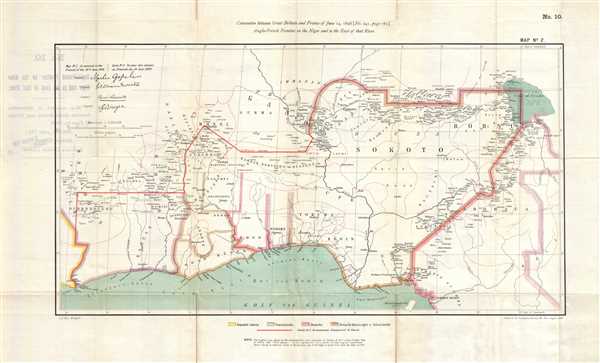
This is an 1898 War Office map of West Africa. The map depicts the region from Liberia to Cameroon and from the Niger River to the Gulf of Guinea. Created from Justus Perthe's 1892 Map of Africa solely for the purpose of the Anglo-French Boundary Commission to illustrate the boundary east of the Niger River, 'all superfluous detail having to reference to the boundary east of the Niger, or to the fiscal zone, has been omitted.' Liberia is illustrated on the far left, and then French and German colonial possessions and British colonies and protectorates occupy the rest the map. The Bight of Benin is depicted and labeled. Cities, towns, and villages are labeled, along with some rivers and mountains. Numerous African tribes are identified by name, including the Sokoto, Bornu, Benin, Adamaua, Baule, Gando, and Mossi. Lake Chad is illustrated in detail along the right border. A key, explaining the different colors used to mark the lands claimed by which countries, is situated at center below the map.
This map was produced and printed by the Intelligence Division of the War Office.
This map was produced and printed by the Intelligence Division of the War Office.
Cartographer
The British War Office (1857 - 1964) was a department of the British Government responsible for the administration of the Royal Army until 1964, when its functions were transferred to the Ministry of Defense. The War Office was to the Royal Army what the Admiralty was to the Royal Navy, and later, the Air Ministry. Within the War Office, the General Staff Topographical Section was responsible for thousands of maps issued for British intelligence and military use. The Topographical Section was renamed Geographical Section in April 1907. Many, once their military use passed, were offered through licensed agents to the general public. The sole London agent for War Office material was Edward Stanford. More by this mapmaker...
Condition
Very good. Light wear and toning along original fold lines. Verso repairs to fold separations. Some text on verso.
References
OCLC 657134727.