
This item below is out of stock, but another example (left) is available. To view the available item, click "Details."
Details
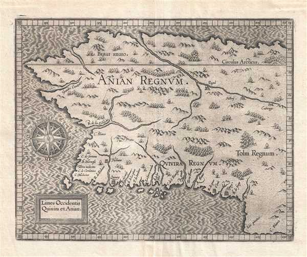
1597 Wytfiet Map of Anian (Alaska, Pacific Northwest)
$2,500.00
1607 Wytfiet Map of Anian (Alaska, Pacific Northwest)
AnianRegnum-wytfliet-1607$787.50

Title
Limes Occidentis Quiuira et Anian. / Anian Regnum.
1607 (undated) 9 x 11 in (22.86 x 27.94 cm) 1 :23500000
1607 (undated) 9 x 11 in (22.86 x 27.94 cm) 1 :23500000
Description
A beautiful example of the 1607 edition of Cornelis avn Wytfliet's Anian Regnum. One of Wytfliet's more enigmatic productions, this map speculatively illustrates must of the west coast of the United States, Canada, and Alaska. Although significantly larger latitudinally, the westward reaching bulge bears a striking and purely coincidental resemblance to modern day Alaska. The basic cartography employed here by Wytfliet was derived from the 1569 world map of Gerard Mercator. Wytfliet identifies several cities and kingdoms, most of which are mythical. These include Anian, Quivira, and Tolm. He further identifies the cities of Tuchano, Quivira, Cicuic, and Tignex on the west coast; and Pagul, Salboy, and Cibirago, along an inland river system just south of the Arctic Circle. The sources of some of these place names are unknown, but others are traceable to the exploration of Cabrillo and from Coronado's expedition to Cibola. The kingdoms of Bergi and Tolm were transposed to the Americas from earlier maps of Asia.
Wytfilet first published this map in 1597. A second state appeared in 1607 and corresponds with the current example. The only difference between the two states is the removal of the 1597 date from the title cartouche. Cartographically they are identical. Wytfliet published this map in his Descriptionis Ptolemaicae Augmentum, essentially an supplement to Ptolemy's Geographica intended to account for the discovery of the New World.
Wytfilet first published this map in 1597. A second state appeared in 1607 and corresponds with the current example. The only difference between the two states is the removal of the 1597 date from the title cartouche. Cartographically they are identical. Wytfliet published this map in his Descriptionis Ptolemaicae Augmentum, essentially an supplement to Ptolemy's Geographica intended to account for the discovery of the New World.
Cartographer
Cornelius van Wytfliet (1555 - 1597) was a Flemish cartographer and engraver active in the second half of the 16th century. Little unfortunately is known of Wytfliet's life or education. He seems to have been employed as secretary to the Council of Brabant, essentially the supreme court of the Duchy of Brabant. In cartographic circles Wytfliet is best known for his publication in 1597 of Descriptionis Ptolemaicae Augmentum, the first atlas dedicated exclusively to the America's. Wytfliet imaged the atlas as a supplement to classical Ptolemaic geographic, which traditionally accounted only for Europe, Africa, and Asia. The 19 maps contained within the Descriptionis Ptolemaicae Augmentum are some of the earliest specific maps detailed various parts of the Americas. More by this mapmaker...
Source
Wytfliet, C., Descriptionis Ptolemaicae augmentum, siue Occidentis notitia breui commentario, (Louvain) 1607.
Wytfliet's Descriptionis Ptolemaicae Augmentum, published in Louvain (Belgium) in 1597, is considered the first atlas specifically dedicated to the Americas. Classical geography, as defined by Claudius Ptolemy's Geographia, only accounted for a three part world - consisting of Asia, Europe, and Africa. The discovery of the Americas in 1492 threw a wrench into this well-established geographic system. Wytfliet imagined his work as a supplement to the Ptolemaic atlas. Drawn from earlier maps, as well as the texts of Acosta, Hakluyt, de Bry, and Ramusio, the Descriptionis Ptolemaicae Augmentum consisted of a history of New Work exploration illustrated by 19 unique maps of the American continent. Many of the individual maps are the first specific illustrations of their respective regions. The work proved popular and went through several editions. The first Latin edition, printed in Louvain, appeared in 1597. Two subsequent Latin ediitons were printed in 1598 and 1603. Further editions appeared in 1605, 1607, and 1611.
Condition
Very good. Expertly repaired wormhole along top centerfold. Wide margins. Original platemark visible. Crisp strong impression. Blank on verso.
References
OCLC: 500525121. Burden, P., The Mapping of North America, 107. Brown University, JCB Library, F597 W996d /1-SIZE.