This item has been sold, but you can get on the Waitlist to be notified if another example becomes available, or purchase a digital scan.
1712 Wells Map of Ancient Greece
AntientGreece-wells-1712$125.00

Title
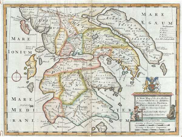
A New Map of the So. and Mid. Parts of Antient Greece viz. Epirus, Hellas, or Graecia Propria, and Peloponnesus, together with the Adjoyning Islands.
1712 (undated) 15 x 20 in (38.1 x 50.8 cm) 1 : 1000000
1712 (undated) 15 x 20 in (38.1 x 50.8 cm) 1 : 1000000
Description
This is an attractive 1712 map of Ancient Greece by Edward Wells of Oxford. It covers southern Ancient Greece including the Peloponnesus, Cythera, Euboea and several other Greek Islands. Identifies various important cites from antiquity including the Athens, Thebes, Delphi, Corinth, etc.
Following the Battle of Corinth in 146 BC, the Greek peninsula came under Roman rule. The period from 31 BC and AD 180 in Greek history is described as the era of the Pax Romana. This was a period of peace and security when many Greek cities flourished, leading to cultural and economic progress. The classical period in Greek history, which lasted from the 5th century B.C. through the 4th century B.C. greatly influenced the Roman Empire's politics, art, architecture, philosophy and literature. After the fall of the Western Roman Empire, Greece became the center of the eastern Roman or Byzantium Empire.
A large title cartouche is included in the bottom right of the map featuring the coat of arms of the Duke of Gloucester. This, like many other Wells maps, is dedicated to Prince William, Duke of Gloucester and son of Queen Anne, who, when this map was being prepared, was a student at Oxford. Engraved by S. Nicholls and published by T. Bonwicke for the 1712 edition of Edward Wells' Atlas, A New Sett of Maps both of Ancient and Present Geography.
Cartographer
Edward Wells (1667 - 1727) was an English mathematician, geographer, and classical scholar based at Christ Church College, Oxford. Wells trained for the ministry but quickly found himself unsuited to religious life and instead applied for an academic position at Oxford, where he authored numerous well respected works on a wide range of mathematical and scientific topics. He tutored Prince William, the sickly son of Queen Anne, who was likely about 11 at the time this map was prepared. Wells dedicated nearly all of the maps in his atlas, A New Sett of Maps both of Ancient and Present Geography, to the young prince - quite possibly posthumously, as William died in July of 1700 shortly prior to the publication of the atlas. Nonetheless, Wells' geography proved popular and was published in number editions well into the 1730s. More by this mapmaker...
Source
Wells, E., A New Sett of Maps both of Ancient and Present Geography, (London, T. w. Bonwicke) c. 1712.
Condition
Very good. Some restored splitting and toning along original centerfold. Minor spotting. Original platemark visible. Backed with archival tissue for stability.
References
OCLC: 43194186.