This item has been sold, but you can get on the Waitlist to be notified if another example becomes available, or purchase a digital scan.
1719 Chatelain map of the French Antilles
Antilles-chatelain-1719$250.00

Title
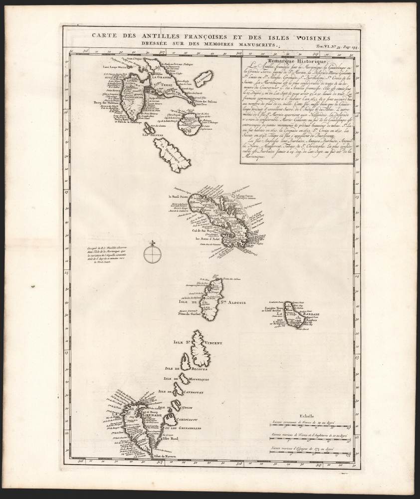
Carte des Antilles Françoises et des Isles Voisines Dressée sur des Memoires Manuscrits.
1719 (undated) 19 x 13 in (48.26 x 33.02 cm) 1 : 1200000
1719 (undated) 19 x 13 in (48.26 x 33.02 cm) 1 : 1200000
Description
This is a superb example of Henri Chatelain's 1719 map of French Antilles, from Guadeloupe to Granada (the southernmost of the Leeward Islands) and the all the Windward Islands.
A Closer Look
The map covers the predominately French portion of the West Indies, including the Grenadines, St. Vincent, Dominica, St. Lucia (Alouise), Barbados, Martinique, and Marie-Galante, among others. It follows the similarly-titled map published in 1717 by Guillaume De l'Isle, and was thus state of the art.Une 'Petit' gaffe
Unfortunately, the 'memoires manuscrits' that De l'Isle had used were a manuscript produced by Thimothee Petit, 'Arpenteur Jure de la Martinique' (Royal Surveyor of Martinique). Petit reconciled local surveys of various islands with the general geography of the West Indies, and De l'isle copied Petit's manuscript almost verbatim. One glaring result of De l'Isle's faith in Petit is the presentation of the island of Grenada both upside-down and to the west, rather than to the south, of the lower Grenadines. Petit's error has been attributed to simply running out of paper combined with an attempt to show the French Antilles within the greater continuity of the Windward Isles. For De l'Isle, this was a gross and uncharacteristic misstep that earned considerable critique in scientific and cartographic circles. These had apparently not reached, or not convinced, Chatelain: his map, produced a scant two years later, preserves all of De l'Isle's detail, both correct and incorrect.Publication History
This map was issued in volume 6 of Chatelain's Atlas Historique ou Nouvelle Introduction à l’histoire à la Chronologie et à la Géographe Ancienne et Moderne. The atlas is well represented in institutional collections; five examples of the separate map appear in OCLC, but it does appear on the market from time to time.CartographerS
Henri Abraham Chatelain (1684 - 1743) was a Huguenot pastor of Parisian origins. He lived consecutively in Paris, St. Martins, London (c. 1710), The Hague (c. 1721) and Amsterdam (c. 1728). He is best known as a Dutch cartographer and more specifically for his cartographic contribution in the seminal seven volume Atlas Historique, published in Amsterdam between 1705 and 1720. Innovative for its time, the Atlas Historique combined fine engraving and artwork with scholarly studies of geography, history, ethnology, heraldry, and cosmography. Some scholarship suggests that the Atlas Historique was not exclusively compiled by Henri Chatelain, as is commonly believed, but rather was a family enterprise involving Henri, his father Zacharie and his brother, also Zacharie. More by this mapmaker...
Guillaume De l’Isle (1675 - 1726) was a French cartographer, and arguably the finest mapmaker at the beginning of the eighteenth century. He was the son of Claude De L'Isle (1644 -1720), a Paris-based historian and geographer under Nicholas Sanson, then the leading light of French cartography. He was the chief proponent of the school of 'positive geography' and the primary figure defining the heights of the Golden Age of French Cartography. Guillaume's skill as a cartographer was so prodigious that he drew his first map at just nine years of age. He was tutored by J. D. Cassini in astronomy, science, mathematics and cartography. By applying these diverse disciplines to the vast stores of information provided by 18th century navigators, Guillaume created the technique that came to be known as 'scientific cartography', essentially an extension of Sanson's 'positive geography'. This revolutionary approach transformed the field of cartography and created a more accurate picture of the world. Among Guillaume's many firsts are the first naming of Texas, the first correct map of the Mississippi, the final rejection of the insular California fallacy, and the first identification of the correct longitudes of America. Stylistically De L'Isle also initiated important changes to the medium, eschewing the flamboyant Dutch style of the previous century in favor of a highly detailed yet still decorative approach that yielded map both beautiful and informative. Guillaume was elected to the French Academie Royale des Sciences at 27. Later, in 1718, he was also appointed 'Premier Geographe du Roi', an office created especially for him. De L'Isle personally financed the publication of most of his maps, hoping to make heavy royalties on their sales. Unfortunately he met an untimely death in 1728, leaving considerable debt and an impoverished child and widow. De L'Isle's publishing firm was taken over by his assistant, Phillipe Buache, who would also become his son in law. Learn More...
Source
Chatelain, Zacharie, Atlas Historique ou Nouvelle Introduction à l’histoire à la Chronologie et à la Géographe Ancienne et Moderne, Volume 6, (Amsterdam) 1719.
Condition
Excellent. Some marginal soiling to left well away from printed image, else fine with a superb strike.
References
OCLC 913365815. Rumsey 13272.742.