This item has been sold, but you can get on the Waitlist to be notified if another example becomes available, or purchase a digital scan.
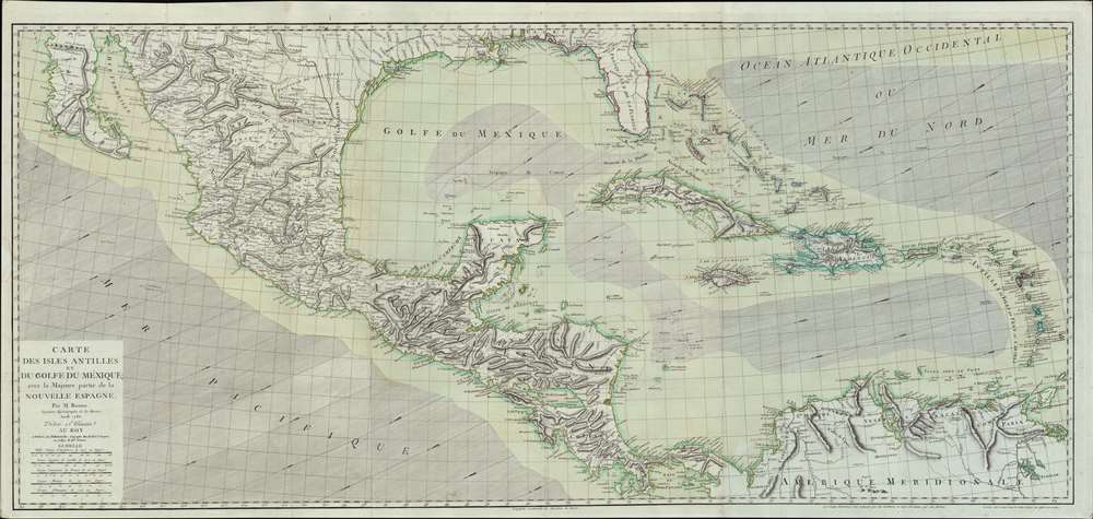
1786 Bonne Map of the Florida, the West Indies, and the Gulf of Mexico
AntilliesGolfeduMexique-bonne-1786$2,475.00

Title
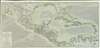
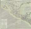
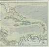
Carte des Isles Antilles et du Golfe du Méxique; avec la Majeure partie de la Nouvelle Espagne.
1786 (dated) 29.5 x 58 in (74.93 x 147.32 cm) 1 : 3700000
1786 (dated) 29.5 x 58 in (74.93 x 147.32 cm) 1 : 3700000
Description
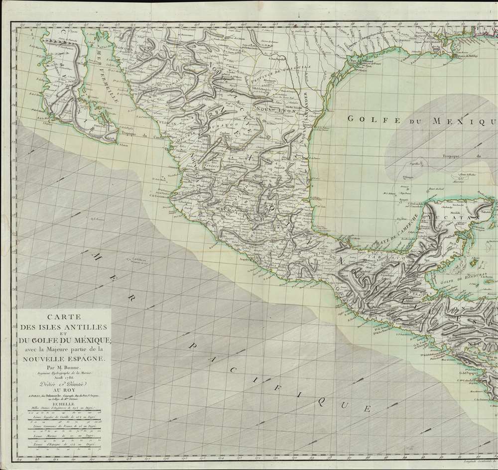
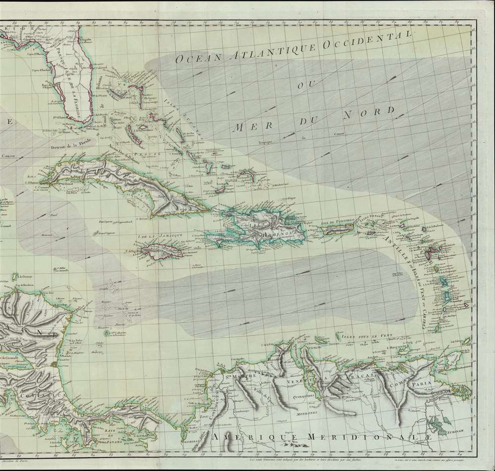
A spectacular large-scale 1786 Rigobert Bonne map of Florida, the West Indies, the Gulf of Mexico, and the Caribbean. This finely engraved and enormous map represents the best and most detailed general map of the West Indies to appear during and shortly after the American Revolutionary War (1775 - 1783). Coverage extends from Baja California and the Pacific to Barbados, and from northern Florida to the Gulf of Panama, including all of Central America, Mexico, parts of the Spanish Main, and the Greater and Lesser Antilles. The map includes a finely engraved illustration of the prevailing winds - important information for regional maritime commerce. Tiny anchors mark safe anchorages. Colonial claims are color coded, with the British represented in red, The Spanish in yellow, and the French in blue.
A Closer Look Inland
Some inland detail is included, particularly in Mexico and the Greater Antilles, where inland provinces, cities, river systems, and topography receive a full treatment. Even Florida - at a time when the interior was mostly unknown, has some interesting inland content, with the Native American villages of Suglia, Dest, Cacena, Mayaco, and Yameses, among others, noted.French Blue Paper
The map is printed on fine laid paper with a distinctly blue tint. Blue paper appear in Europe as early as the 15th century, but rose exponentially in popularity in the second half of the 18th century. At the time, paper mills collected used rags, which were then broken down into fibers and processed into paper - hence the term 'rag paper'. Blue dies were popular in the European fine-textile industry - particularly among the elite who used blue fabrics for table linens, bed linens, and clothing. Blue dies were less fugitive than other colors, and so were preserved through the paper making pulpification process. Papermakers began experimenting with adding small amounts of blue pulp to bleached white pulps, to even out color and tone - often leading to fine papers with a striking bluish cast - as here. During the French Revolution (1789 - 1799), the linen closets of the nobility were raided with many of the fine textiles finding their way into paper mills. This led to a surplus of blue scrap cloth and consequently, blue paper. Most printing on blued paper dates to this period. Nonetheless, by the end of the 18h century, the fashion for blue paper declined considerably in favor of more traditional white. Today, maps produced from French Revolution blue paper are highly desirable.Publication History and Census
This map was drawn by Rigobert Bonne and first published by Jean Lattré in 1780. A second issue by Lattré appeared in 1782. Subsequently, the plate passed to Charles-François Delamarche, who issued the present 1786 edition. The map is quite scarce. The OCLC notes examples at 7 institutions, including Harvard, the Library of Congress, and Getty Research Library. Of this specific edition, we note only a single example, at the Library of Congress.CartographerS
Rigobert Bonne (October 6, 1727 - September 2, 1794) was one of the most important French cartographers of the late 18th century. Bonne was born in Ardennes à Raucourt, France. He taught himself mathematics and by eighteen was a working engineer. During the War of the Austrian Succession (1740 - 1748) he served as a military engineer at Berg-op-Zoom. It the subsequent years Bonne became one of the most respected masters of mathematics, physics, and geography in Paris. In 1773, Bonne succeeded Jacques-Nicolas Bellin as Royal Cartographer to France in the office of the Hydrographer at the Depôt de la Marine. Working in his official capacity, Bonne compiled some of the most detailed and accurate maps of the period - most on an equal-area projection known erroneously as the 'Bonne Projection.' Bonne's work represents an important step in the evolution of the cartographic ideology away from the decorative work of the 17th and early 18th century towards a more scientific and practical aesthetic. While mostly focusing on coastal regions, the work of Bonne is highly regarded for its detail, historical importance, and overall aesthetic appeal. Bonne died of edema in 1794, but his son Charles-Marie Rigobert Bonne continued to publish his work well after his death. More by this mapmaker...
Charles-François Delamarche (August 1740 - October 31, 1817) founded the important and prolific Paris-based Maison Delamarche map publishing firm in the late 18th century. A lawyer by trade, Delamarche entered the map business with the 1787 acquisition from Jean-Baptiste Fortin of Robert de Vaugondy's map plates and copyrights. Delamarche appears to have been of dubious moral character. In 1795, the widow of Didier Robert de Vaugondy, Marie Louise Rosalie Dangy, petitioned a public committee for 1500 livres, which should have been awarded to her deceased husband. However, Delamarche, proclaiming himself Vaugondy's heir, filed a simultaneous petition and walked away with the funds, most of which he was instructed to distribute to Robert de Vaugondy's widow and children. Just a few months later, however, Delamarche proclaimed Marie Dangy deceased, and it is highly unlikely that any funds found their way to Robert de Vaugondy's impoverished daughters. Nonetheless, where Robert de Vaugondy could barely make ends meet as a geographer, Delamarche prospered as a map publisher, acquiring most of the work of earlier generation cartographers Lattre, Bonne, Desnos, and Janvier, thus expanding significantly upon the Robert de Vaugondy stock. Charles Delamarche eventually passed control of the firm to his son Felix Delamarche (c. 1750 - c. 1850) and geographer Charles Dien (1809 - 1870). It was later passed on to Alexandre Delamarche, who revised and reissued several Delamarche publications in the mid-19th century. The firm continued to publish maps and globes until the middle part of the 19th century. Learn More...
Condition
Very good. On French blued paper.
References
Library of Congress, G4390 1786 .B6.