This item has been sold, but you can get on the Waitlist to be notified if another example becomes available, or purchase a digital scan.
1937 Osaka Mainichi Shimbun Propaganda Pictorial Map of East Asia
AntiSovietMapEastAsia-osakamainichi-1937-3$425.00

Title
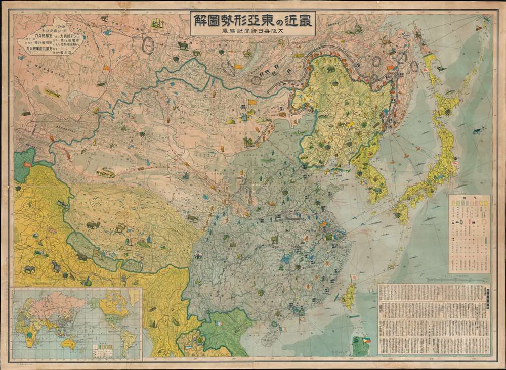
最近の東 亞形勢圖解 / Illustrated Explanation of Recent East Asia Situations. / Saikin no Tōa keisei zukai.
1937 (dated) 30 x 42.5 in (76.2 x 107.95 cm) 1 : 6500000
1937 (dated) 30 x 42.5 in (76.2 x 107.95 cm) 1 : 6500000
Description
A remarkable and rare 1937 large format Japanese anti-Soviet propaganda pictorial map of East Asia. Centered on China, this stunning map covers from Central Asia and India to Japan and from Siberia to Vietnam. The map employs text, color coding, and cartoon imagery to illustrate the confusing political, military, and economic environment in East Asia at this time, express the dangers of Soviet expansionism, and suggest a Japanese military buildup to counter it.
There is so much going on here it is hard to know where to start, but we will begin with the color coding and general message of the map. The three main players on the board are Russia or the Soviet Union (Red), Japan (Yellow) and China (Purple). Lighter red zones are those areas under Communist / Soviet influence, including Mongolia and Qinghai. Regions under Japanese influence, such as Manchuria, are lighter yellow. China (Purple) is the region of contention, with areas Chinese control, such as the five northern Chinese provinces, in light blue. British India and Burma appear in Yellow, while British include areas include Tibet (Peach).
Within China, then embroiled in the Chinese Civil War between the Kuomintang government forces (represented as blue soldiers) and the Communist forces (represented as little red soldiers within China). Note how the Communist forces occupy the Chinese heartland while the blue Kuomintang forces are concentrated on the borders to counter Russian advances. Russian forces, meanwhile, gather on the borders of Manchuria, where Japanese forces, in lesser numbers, maintain a tenuous line of defense. Red lines outline the Soviet strategy for northern China and Manchuria, which involves a horseshoe form, with land forces entering northern China via Mongolia, other armies bottling up the Japanese in Manchuria, and a potential air attack against the Japanese mainland via the Russian base of Vladivostok.
The map further makes some offer to illustrate the wealth of resources throughout the region via a series of pictorial vignettes illustrating everything from oil rigs, to coal mines, to livestock, to gold and copper deposits. Among the resources are hemp plants illustrated in Manchuria, China, and northern Luzon, although to be fair, at the time cannabis was more valuable for making ropes and clothing than as a drug. Apart from livestock, Russian territories are relatively lacking in resources, while Korea, Manchuria, and China are exceptionally rich, highlighting their intrinsic value for whatever power might seize them.
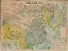
In the lower left a world map on a Japan-centered Mercator projection. The coverage area f this map are highlighted. The color coding reflects colonial powers, such as orange for England, Red for Japan, Brown for Italy, and light red for the Soviet Union.
In the upper left corner there is a tank-shaped text block offering a comparative breakdown of Russian versus Chinese military might. As follows:
There is so much going on here it is hard to know where to start, but we will begin with the color coding and general message of the map. The three main players on the board are Russia or the Soviet Union (Red), Japan (Yellow) and China (Purple). Lighter red zones are those areas under Communist / Soviet influence, including Mongolia and Qinghai. Regions under Japanese influence, such as Manchuria, are lighter yellow. China (Purple) is the region of contention, with areas Chinese control, such as the five northern Chinese provinces, in light blue. British India and Burma appear in Yellow, while British include areas include Tibet (Peach).
Within China, then embroiled in the Chinese Civil War between the Kuomintang government forces (represented as blue soldiers) and the Communist forces (represented as little red soldiers within China). Note how the Communist forces occupy the Chinese heartland while the blue Kuomintang forces are concentrated on the borders to counter Russian advances. Russian forces, meanwhile, gather on the borders of Manchuria, where Japanese forces, in lesser numbers, maintain a tenuous line of defense. Red lines outline the Soviet strategy for northern China and Manchuria, which involves a horseshoe form, with land forces entering northern China via Mongolia, other armies bottling up the Japanese in Manchuria, and a potential air attack against the Japanese mainland via the Russian base of Vladivostok.
The map further makes some offer to illustrate the wealth of resources throughout the region via a series of pictorial vignettes illustrating everything from oil rigs, to coal mines, to livestock, to gold and copper deposits. Among the resources are hemp plants illustrated in Manchuria, China, and northern Luzon, although to be fair, at the time cannabis was more valuable for making ropes and clothing than as a drug. Apart from livestock, Russian territories are relatively lacking in resources, while Korea, Manchuria, and China are exceptionally rich, highlighting their intrinsic value for whatever power might seize them.
In the lower left a world map on a Japan-centered Mercator projection. The coverage area f this map are highlighted. The color coding reflects colonial powers, such as orange for England, Red for Japan, Brown for Italy, and light red for the Soviet Union.
In the upper left corner there is a tank-shaped text block offering a comparative breakdown of Russian versus Chinese military might. As follows:
- Russian Forces: 300,000 / Chinese Forces: 2,200,000
- Military Aircraft: 1000 (R) / 700 (C)
- Russian Tanks: 1000
- Russian Heavy Bombers: 70
- Russian Submarines: 40
- Chinese Communist Forces: 200,000
Cartographer
The Osaka Mainichi Shimbun (大阪毎日新聞; 1876 - 1942) was an Osaka based daily newspaper active in the late 19th and early 20th century. The Osaka Mainichi Shimbun (大阪毎日新聞, Osaka Daily News) was founded in 1876 as Osaka Nippo(大阪日報). In 1888 it was renamed Osaka Mainichi Shimbun. In 1911 it merged with the Tokyo Nichi Nichi Shimbun (東京日日新聞), but both companies continued to print their newspapers independently until 1943, they were consolidated under the Mainichi Shimbun (毎日新聞, Daily News) masthead. The Mainichi Shimbun is today one of Japans larges and longest lasting newspapers. More by this mapmaker...
Condition
Good. Overall toning. Some minor soiling. Fold wear. Laid on Japan paper.
References
OCLC 127724862, 47544666.