This item has been sold, but you can get on the Waitlist to be notified if another example becomes available, or purchase a digital scan.
1921 Admiralty Nautical Chart / Map of Hobart, Tasmania
ApproachesHobart-admiralty-1921$175.00


Title
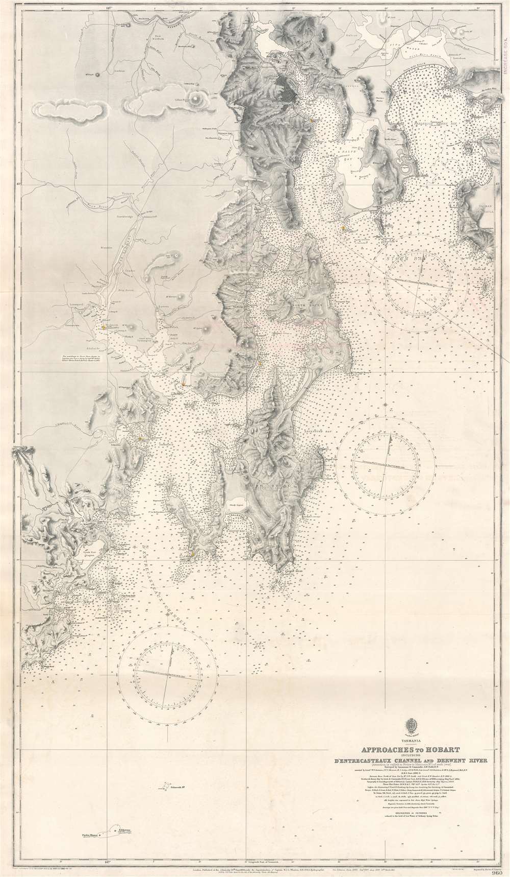
Approaches to Hobart Including D'Entrecasteaux Channel and Derwent River.
1921 (dated) 47 x 27 in (119.38 x 68.58 cm) 1 : 107000
1921 (dated) 47 x 27 in (119.38 x 68.58 cm) 1 : 107000
Description
This is a 1921 British Admiralty nautical chart or maritime map of the approaches to Hobart, Tasmania, the Australian island state's capital and most populous city. Coverage extends from Mt. Lord south to Piedra Blanca and from Adamson Peak east to the Tasman Peninsula and Wedge Bay. Coastal bays, capes, beaches, and points, and other features are identified with countless depth soundings throughout. The Derwent River is presented in precise detail. Rivers, mountains, and other physical features near the coast are illustrated and labeled, but very little detail is present inland. The Main Line Railway, the Sorell Railway, and the Derwent Valley Railway are illustrated.
Publication History and Census
This chart was created and first published by the British Admiralty under the Superintendence of William James Lloyd Wharton on June 20, 1889. The chart then underwent numerous updates and new editions, with the present example updated to 1921. We have been unable to locate any other examples of the 1921 edition either in public or private hands and only four examples of other editions are cataloged in OCLC. Each of these also represents the only example of a given edition. All editions are scarce on the private market.CartographerS
The British Admiralty Office (1795 - Present) or the United Kingdom Hydrographic Office refers to the Branch of the English government that is responsible for the command of the British Navy. In 1795 King George III created the United Kingdom Hydrographic Office, known in short as the U.K.H.O., to provide top notch nautical charts to the vast Royal Navy. Prior the founding of the Admiralty the surveying and creation of nautical charts was primarily a commercial venture wherein the cartographer himself, more of than not, actually financed the printing of his own material. The great navigator Cook himself is known to have scrambled for funds to publish his own seminal charts - the most important and advanced of the period. The system of privately funded nautical mapping and publishing left vast portions of the world uncharted and many excellent charts unpublished. King George III, responding significant loss in trade revenue related to shipwrecks and delay due to poor charts, recognized the need for an institutionalized government sponsored cartographic agency - the Admiralty. The first head of the Admiralty, a position known as Hydrographer, was the important cartographer Alexander Dalrymple. Dalrymple started by organizing and cataloging obtainable charts before initiating the laborious process of updating them and filling in the blanks. The first official Admiralty Chart appeared in 1800 and detailed Quiberon Bay in Brittany. By 1808 the position of Hydrographer fell to Captain Thomas Hurd. Hurd advocated the sale of Admiralty charts to the general public and, by the time he retired in 1829, had issued and published some 736 charts. Stewardship of the organization then passed to Rear Admiral Sir Francis Beaufort. It was under Beaufort's administration that the Admiralty truly developed as a "chart making" as opposed to a "chart cataloging" institution. Beaufort held his post from 1829 to 1854. In his 25 years at the Admiralty Beaufort created nearly 1500 new charts and sponsored countless surveying and scientific expeditions - including the 1831 to 1836 voyage of the H.M.S. Beagle. By 1855 the Admiralty's chart catalog listed some 1,981 charts. More by this mapmaker...
Admiral Sr William James Lloyd Wharton (March 2, 1843 - September 29, 1905), a British admiral and Hydrographer of the Navy, was born in London and was educated at Barney's Academy, Gosport. Then, at the age of fourteen, Wharton entered the Royal Naval Academy in August 1857. Confirmed as a lieutenant in March 1865, Wharton undertook his first surveying work aboard the HMS Gannet, in the Bay of Fundy and other locations. After being promoted to commander in March 1872, Wharton was put in command of the Shearwater, a surveying vessel, which undertook surveys of the Mediterranean, the Bosphorus, and the Sea of Marmara. Wharton was promoted to captain in 1880 and soon published his book entitled Hydrographical Surveying. This work quickly gained a reputation as the standard work on the subject. He also was in charge of an expedition to survey the River Plate (Rio de la Plata) and the Straits of Magellan, after which he was named Hydrographer of the Navy on August 1, 1884, a position he held for the next twenty years. In July 1904 he retired as Hydrographer of the Navy. Other accomplishments during his career include taking part in the survey that established the longitude of the Seychelles and heading an expedition to survey part of the coast of East Africa. He was promoted to rear-admiral in 1895. A capable scientist, Wharton was made a Fellow of the Royal Society in 1886, and was also named a Fellow of the Royal Astronomical Society and a Fellow of the Royal Geographical Society. He was also a member of the Royal Meterological Society. While on a journey back from Victoria Falls in South Africa, Wharton contracted the disease that killed him. He died of enteric fever and pneumonia in Cape Town on September 29, 1905. Learn More...
Davies and Company (fl. c. 1880 - 1930) was an engraving and lithography firm active in London during the late 19th century. The firm engraved nautical charts for the British Admiralty Hydrographic offices in the 1880s to the early 1920s. The firm may be the successor of Davies, Bryer, and Company (fl. 1866 - 1872), who also worked with the Admiralty, which dissolved in 1872. It may also be related to the firm of Robert Davies, Maddock, and Company, which was dissolved in 1905. Their imprint, as Davies and Company, appears as early as 1880 and as late as the 1920s, but the firm may have closed its doors by that point and the imprints persist on map plates only as a legacy. Learn More...
Condition
Very good. Exhibits light wear along original fold lines. Closed margin tears professionally repaired on verso. Exhibits writing on verso.