This item has been sold, but you can get on the Waitlist to be notified if another example becomes available, or purchase a digital scan.
1786 Schrämbl Wall Map of Persia, Arabia and India
ArabiaPersiaIndia-schraembl-1786-2$600.00


Title
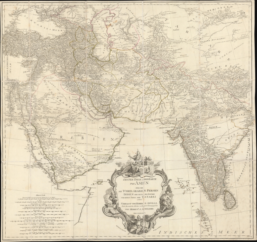
Erster Theil der Karte von Asien welche die Türkei, Arabien, Persien Indien diesseits des Ganges und einen Theil der Tatarei enthält.
1786 (dated) 30 x 31 in (76.2 x 78.74 cm) 1 : 6900000
1786 (dated) 30 x 31 in (76.2 x 78.74 cm) 1 : 6900000
Description
A striking 1786 separate-issue F. A. Schrämbl map of India, Persia, and Arabia. It is based upon the best cartographic sources of the era and was engraved for one of the first Austrian world atlases, Schrämbl's Allgemeiner Grosser Atlas. The present example is a separate issue likely predating the 1800 publication of the atlas.
When this map was issued, the eastern portions, including Turkey, Arabia, and most of the modern-day Middle East, were under the waning hegemony of the Ottoman Empire. In Arabia, the First Sau had already been established in 1744 and, though owing nominal allegiance to Istanbul, dominated the central Arabian Peninsula. The presumptively more valuable coastal lands and river valleys of Mesopotamia (Iraq) remained under direct Ottoman suzerainty.
Persia at this time was itself experiencing the waning years of the short-lived Zand Dynasty, who ruled from Isfahan - identified here. In 1794, Aga Muhammad Khan overthrew Loft Ali Khan, the last Shah of the Zand, and relocated the capital to the new city of Tehran. The subsequent era, the Qajar Dynasty, witnessed constant military conflicts with Imperial Russia and the loss of much of Persia's territory.
India meanwhile was falling under the control of the British East India Company who, from a few coastal outposts, eventually asserted authority over most of the subcontinent, leaving only the Sultanate of Mysore, under Tipu Sultan, independent. In 1784, two years before this map was issued, Tipu Sultan negotiated the Treaty of Mangalore, ending the Second Anglo-Mysore War (1780 - 1784). The treaty gave Tipu Sultan only a short reprieve but was considered a victory for Mysore. Nonetheless, the Third and Fourth Anglo-Mysore Wars were soon to follow, and by 1799, Tipu Sultan had been defeated, and all of India fell to the British East India Company.
A Closer Look
Centered on Persia, coverage extends from Istanbul to eastern India and Tibet and from the Black Sea to the Maldives. Schrämbl (Schraembl) based this map on the cartography of the influential J. B. B. d'Anville, who published a similar map in 1751. By adopting this map as his source, Schrämbl chose the best existing cartography. The map offers excellent coverage of the central Asian portions of the Silk Route, naming the centers of Samarkand, Bukhara, Lop Nor, and others. At the bottom center, there is a large decorative title cartouche including stylized Christian, Muslim Zoroastrian, and Buddhist elements.When this map was issued, the eastern portions, including Turkey, Arabia, and most of the modern-day Middle East, were under the waning hegemony of the Ottoman Empire. In Arabia, the First Sau had already been established in 1744 and, though owing nominal allegiance to Istanbul, dominated the central Arabian Peninsula. The presumptively more valuable coastal lands and river valleys of Mesopotamia (Iraq) remained under direct Ottoman suzerainty.
Persia at this time was itself experiencing the waning years of the short-lived Zand Dynasty, who ruled from Isfahan - identified here. In 1794, Aga Muhammad Khan overthrew Loft Ali Khan, the last Shah of the Zand, and relocated the capital to the new city of Tehran. The subsequent era, the Qajar Dynasty, witnessed constant military conflicts with Imperial Russia and the loss of much of Persia's territory.
India meanwhile was falling under the control of the British East India Company who, from a few coastal outposts, eventually asserted authority over most of the subcontinent, leaving only the Sultanate of Mysore, under Tipu Sultan, independent. In 1784, two years before this map was issued, Tipu Sultan negotiated the Treaty of Mangalore, ending the Second Anglo-Mysore War (1780 - 1784). The treaty gave Tipu Sultan only a short reprieve but was considered a victory for Mysore. Nonetheless, the Third and Fourth Anglo-Mysore Wars were soon to follow, and by 1799, Tipu Sultan had been defeated, and all of India fell to the British East India Company.
Publication History and Census
Schrämbl prepared this map in 1786 for inclusion in his monumental Allgemeiner Grosser Atlas. Although most of the constituent maps were engraved in 1786, the atlas remained unpublished until 1800. Before that time, many of the maps were issued separately, as here. The Allgemeiner Grosser Atlas was expensive and proved difficult to sell, resulting in a low publican run and considerable scarcity. OCLC shows separate map catalogued in only ten institutional collections; the complete atlas is shown only in three, the Staatsbibliothek Zu Berlin, the Institut Fuer Laender Bunde, and the Universiteit Leiden.CartographerS
Jean Baptiste Bourguignon d'Anville (1697 - 1782) was perhaps the most important and prolific cartographer of the 18th century. D'Anville's passion for cartography manifested during his school years when he amused himself by composing maps for Latin texts. There is a preserved manuscript dating to 1712, Graecia Vetus, which may be his earliest surviving map - he was only 15 when he drew it. He would retain an interest in the cartography of antiquity throughout his long career and published numerous atlases to focusing on the ancient world. At twenty-two D'Anville, sponsored by the Duke of Orleans, was appointed Geographer to the King of France. As both a cartographer and a geographer, he instituted a reform in the general practice of cartography. Unlike most period cartographers, D'Anville did not rely exclusively on earlier maps to inform his work, rather he based his maps on intense study and research. His maps were thus the most accurate and comprehensive of his period - truly the first modern maps. Thomas Basset and Philip Porter write: "It was because of D'Anville's resolve to depict only those features which could be proven to be true that his maps are often said to represent a scientific reformation in cartography." (The Journal of African History, Vol. 32, No. 3 (1991), pp. 367-413). In 1754, when D'Anville turned 57 and had reached the height of his career, he was elected to the Academie des Inscriptions. Later, at 76, following the death of Philippe Buache, D'Anville was appointed to both of the coveted positions Buache held: Premier Geographe du Roi, and Adjoint-Geographer of the Academie des Sciences. During his long career D'Anville published some 211 maps as well as 78 treatises on geography. D'Anville's vast reference library, consisting of over 9000 volumes, was acquired by the French government in 1779 and became the basis of the Depot Geographique - though D'Anville retained physical possession his death in 1782. Remarkably almost all of D'Anville's maps were produced by his own hand. His published maps, most of which were engraved by Guillaume de la Haye, are known to be near exact reproductions of D'Anville' manuscripts. The borders as well as the decorative cartouche work present on many of his maps were produced by his brother Hubert-Francois Bourguignon Gravelot. The work of D'Anville thus marked a transitional point in the history of cartography and opened the way to the maps of English cartographers Cary, Thomson and Pinkerton in the early 19th century. More by this mapmaker...
Franz Anton Schrämbl (Schraembl; 1751 - December 13, 1803) was a Vienna-based cartographer working in the later part of the 18th century. Schrämbl was born in Vienna. He became director of the normal school in Troppau but soon quit to set up a bookshop in Vienna. In 1787, with fellow Austrian Franz Johann Joseph von Reilly (1766 - 1820), he founded a publishing firm. He began his great work, the Allgemeiner Grosser Atlas, in the same year. This ambitious large format atlas was to be based upon only the most up-to-date cartographic information available, among them cartographers J. B. B. D'Anville (1697 - 1782) and James Rennel (1742 - 1830), and explorers such as James Cook (1728 - 1779), Charles Roberts (1739 - 1825), and others. The atlas was published in 1800 and became the first Austrian commercial world atlas. The work experienced minimal circulation, possibly due to its high cost. The low sales nearly drove Schrämbl into insolvency, but he recovered through diversification into literature and art books. When Franz Anton died in 1803, his widow Johanna and her brother, the engraver Karl Robert Schindelmayer (1769 - 1839), assumed control of the firm. In 1825, his son, Eduard Schrämbl, took over. Learn More...
Source
Schraembl, K. A., Allgemeiner Grosser Atlas, (Vienna: Phil. Jos. Schalbacher) 1800.
The Allgemeiner Grosser Atlas, alternatively titled Allgemeiner Grosser Schrämblischer Atlass, is considered the first Austrian commercial Atlas. It is a massive elephant folio atlas published in 1800 by Franz Anton Schrämbl (Schraembl; 1751 - 1803). The atlas drew from the best and most up-to-date cartographic information available, including the works of J. B. B. D'Anville (1697 - 1782) and James Rennel (1742 - 1830), and explorers such as James Cook (1728 - 1779), and Charles Roberts (1739 - 1825), among many others. It was published in Vienna by Phillip Joseph Schalbacher. The atlas was large and expensive, and as such, was of minimal commercial success and had a low circulate - leading to its considerable rarity today. It is believed that the atlas's slow sales and high production costs drove Schrämbl into insolvency by the time of his death in 1803.
Condition
Very good. Dissected on linen.
References
Phillips, P.L. (Atlases) 694-31. OCLC 165900950.