This item has been sold, but you can get on the Waitlist to be notified if another example becomes available, or purchase a digital scan.
1841 Weiland Map of the Arabian Peninsula and Persian Gulf
Arabien-weiland-1841$1,250.00

Title
Arabien.
1841 (dated) 22 x 21.25 in (55.88 x 53.975 cm) 1 : 5700000
1841 (dated) 22 x 21.25 in (55.88 x 53.975 cm) 1 : 5700000
Description
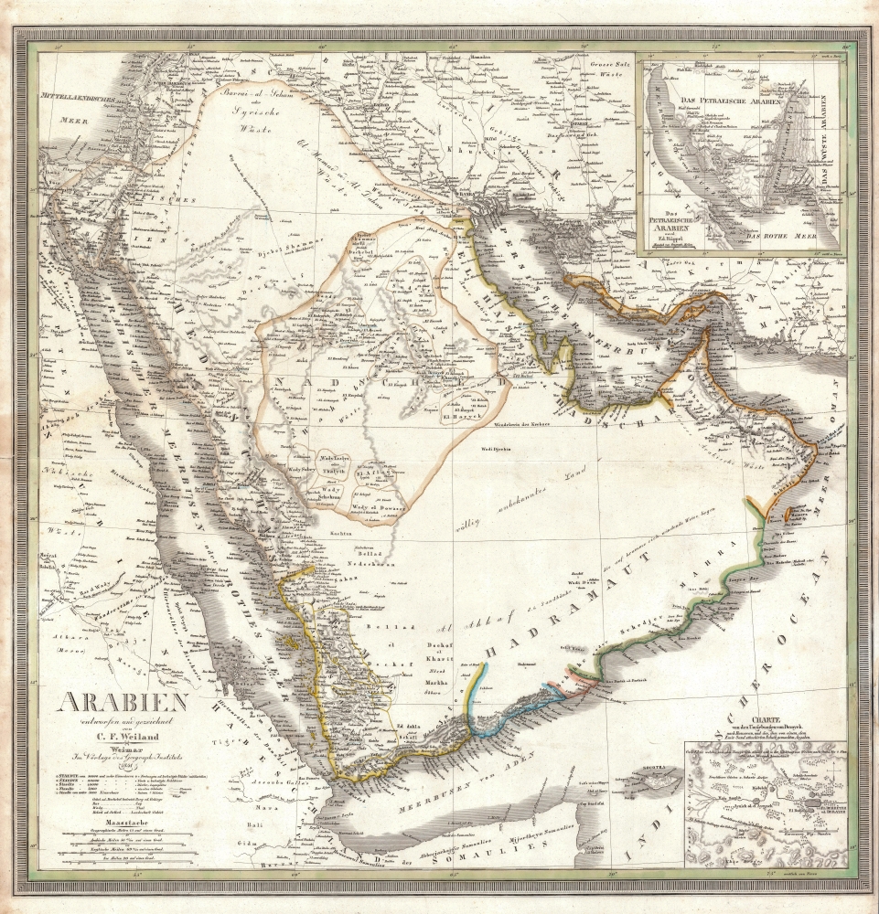
This is an 1841 Carl Ferdinand Weiland map of Arabia - considered one of the earliest modern scientific mappings of the Arabian Peninsula and one of the earliest maps to name Kuwait (El Koueit ox Grane), Dubai (Dubai), and Abu Dhabi (Abuthubbi).
This map represents the most significant update on Arabian cartography in nearly 100 years - since the Carsten Niebuhr’s Danish Arabia Expedition (1761 - 1767). The sources here are unclear, save for the work of Ehrenberg and Rüppell, evident in the insets. The whole offers a considerable update on both the political situation and the topography of the Peninsula - doing away with many of Niebuhr's errors and assumptions.
The second inset represents a major cartographic update on the Sinai Peninsula - the first major cartographic revisions of this region since Niebuhr, based upon the mapping of German naturalists Christian Gottfried Ehrenberg and Eduard Rüppell.
A Closer Look
Centered on the Emirate of Nejd (Second Saudi State), coverage extends from the Sinai to Oman and from Syria to the Gulf of Aden. Weiland maps Arabian cities, towns, and roads with scientific precision, including the pilgrimage routes between Mecca and Medina. Cities outside modern-day Saudi Arabia are also labeled, including Baghdad, Basra, Beirut, Jerusalem, Gaza, Isfahan, and Persepolis.Mapping of Arabia
Arabia was a blank zone for European cartographers of the 18th and 19th centuries. Most of the peninsula was closed to non-Muslims, disputed by rival tribal warlords, and environmentally inhospitable. Nonetheless, by the early 19th century, led by intrepid explorers and cartographers such as Weiland, Kiepert, Ehrenberg, and Rüppell and others, Germany, particularly Weimar, emerged as the center of cartographic thought regarding Arabia.This map represents the most significant update on Arabian cartography in nearly 100 years - since the Carsten Niebuhr’s Danish Arabia Expedition (1761 - 1767). The sources here are unclear, save for the work of Ehrenberg and Rüppell, evident in the insets. The whole offers a considerable update on both the political situation and the topography of the Peninsula - doing away with many of Niebuhr's errors and assumptions.
The Insets
Weiland offers two inset maps of the utmost significance. The first, appearing in the lower right, is a detail of Derayeh (Diriyah), the capital of the first Saudi dynasty from 1744 until 1818, and as this map went to press, the center of the Emirate of Nejd (1824 - 1891). In time, Diriyah would grow to become modern-day Riyadh, the capital of Saudi Arabia.The second inset represents a major cartographic update on the Sinai Peninsula - the first major cartographic revisions of this region since Niebuhr, based upon the mapping of German naturalists Christian Gottfried Ehrenberg and Eduard Rüppell.
Publication History and Census
This map was published in Weimar, Germany, by Carl Ferdinand Weiland at the Geographischen Instituts. It appeared in the 1842 edition of the Allgemeiner Hand Atlas. Seven examples are cataloged in OCLC and are part of the institutional collections at Yale University, Harvard University, the Library of Congress, Utrecht University, the Danish Union Catalogue, the Royal Danish Library, and the Wurttembergische Landesbibliothek. Scarce.CartographerS
Carl Ferdinand Weiland (1782 - 1847) was a German cartographer active with the Weimar Geographisches Institut, where he headed up map and globe production, in early and middle part of the 19th century. Weiland was a trained as a military cartographer who, with his career at the Geographisches Institut, move into the private market. Among his other work, Weiland issued a German edition of Carey and Lea's American Atlas. Their edition, which was fully re-engraved in Germany, is of superior workmanship and stands out as some of the finest 19th century maps of individual U.S. states printed outside of America.Carl Ferdinand Weiland (1782 - 1847) was a German cartographer active with the Weimar Geographisches Institut, where he headed up map and globe production, in early and middle part of the 19th century. Weiland was a trained as a military cartographer who, with his career at the Geographisches Institut, move into the private market. Among his other work, Weiland issued a German edition of Carey and Lea's American Atlas. Their edition, which was fully re-engraved in Germany, is of superior workmanship and stands out as some of the finest 19th century maps of individual U.S. states printed outside of America. More by this mapmaker...
Geographisches Institut, Weimar (fl. 1804 - c. 1903) was a German map and globe publishing house and geographical research institute based in Weimar. The organization primarily focused on republishing and improving upon the works of earlier cartographers, including Kitchin, Jefferys, Carey, and others. In general, its publications are known for their fine engraving, attention to detail, historical accuracy, and overall high quality. The firm was founded in 1804 by Friedrich Justin Bertuch (???? - c. 1845) and, on his death, passed to his son Robert Froreip (???? - 1855), then to Louis Denicks of Luneberg, then in 1859 to Voigt & Günther, in 1883 to F. Arnd, from 1890 - 1893 to Julius Kettler, and in 1903 to Max Wedekind. During the institute's height in the early 19th century, most of its cartographic publication was overseen by Carl Ferdinand Weiland (1782 - 1847). The firm also employed the cartographers Franz Xaver von Zach, Adam Christian Gaspari, Heinrich Kiepert, Karl (or Carl) and Adolf Graef, Julius Kettler, Carl Riemer and Karl Christian Bruhns. Weimar was a logical place for a collective like the Geographisches Institut to arise; it was a cultural mecca in the German-speaking world in the late 18th and 19th centuries because of its liberal atmosphere and associations with figures like Schiller, Herder, and, above all, Goethe, who spent most of his adult life in the city. Learn More...
Source
Weiland, F., Allgemeiner Hand Atlas, (Weimar: Weimar Geographisches Institut) 1842.
Condition
Very good. Some very light foxing. Tight right margin.
References
OCLC 902603701. Rumsey 9074.000.