1598 Braun and Hogenberg Views of Archidona and La Peña de los Enamorados
Archidona-braunhogenberg-1596$750.00

Title
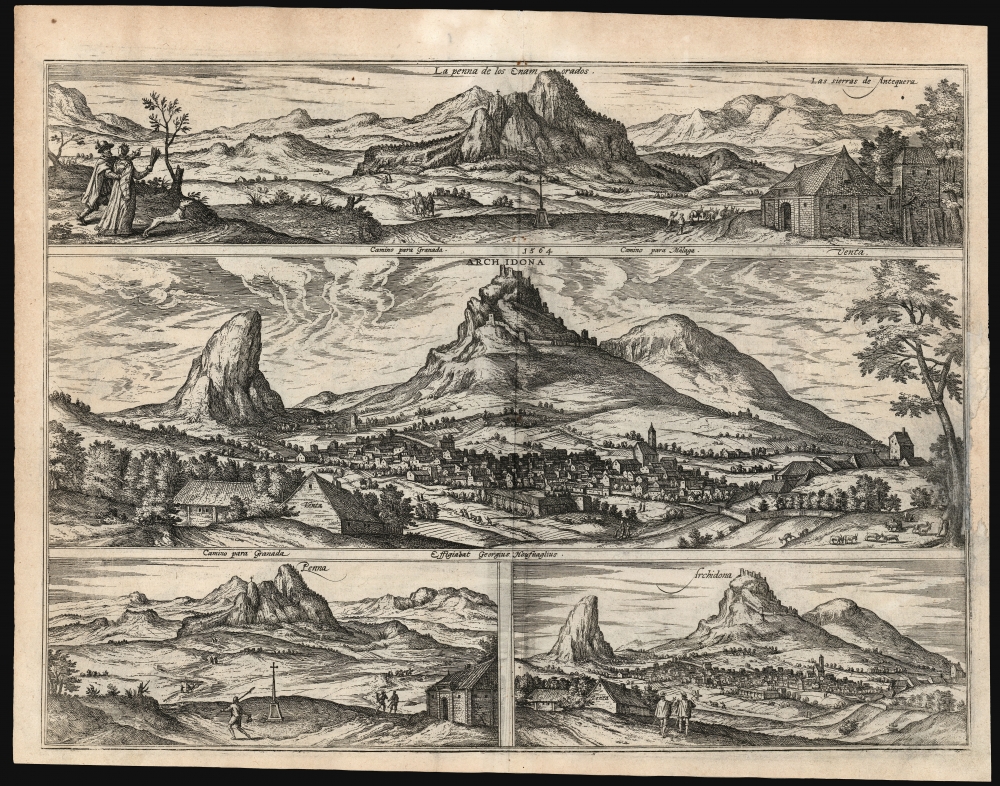
La Penna de los Enamorados. / Archidona. / Penna. / Archidona.
1596 (dated) 14 x 19 in (35.56 x 48.26 cm)
1596 (dated) 14 x 19 in (35.56 x 48.26 cm)
Description
These are Joris Hoefnagel's depictions of the Andalusian town of Archidona, and the distinctive peak of La Peña de los Enamorados dominating it, included in the 1596 fifth volume of Georg Braun and Franz Hogenberg's Civitatis Orbis Terrarum, the first published collection of city plans and views.
A Closer Look
It is not difficult to see why Hoefnagel would have made drawings of these spectacles. Archidona is dramatically overshadowed by distinctive (and extremely accurately depicted) peaks, with the ruins of a Moorish castle looming over the town; the relatively flat region to the west makes Peña de los Enamorados (Lovers' Rock) all the more conspicuous. The latter was a storied peak: legend had it that a Christian knight and the daughter of a Saracen king, bound by a forbidden love, threw themselves to their deaths from atop the mountain (perhaps from the location marked with a cross in the views.) The upper view of La Peña includes to the left a perambulating couple; the gentleman appears to be regaling his companion with the sad tale of the mountain and its star-crossed lovers.Firsthand Views
Although this engraving did not reach print until 1596, Hoefnagel's strikingly accurate drawings were made in 1564, when he was traveling Spain from Antwerp while looking after his business interests there. And these are travelers' views of the town and mountains: both the top and center views (of La Peña and Archidona, respectively, note the location of the road to Granada, and the road to Malaga. In the foreground of each, along the road, is marked a Venta. This was a characteristically Andlusian traditional inn: these could be found typically in isolated stretches of royal roads and crossroads. The one pictured in these views exhibits the characteristic single, large door (accessible to carriages.) Ventas would also include pens for livestock, haystacks for the muledrivers, and rooms to accommodate travelers. The artist indicates that the viewer - situated near the Venta - was able to see La Peña looking towards the west, and Archidona to the east.Four Renditions of Two Views?
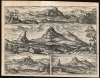
The two bottom views - also of La Peña and Archidona - appear to be simpler versions of the of the two views atop them. This is not explained, although it may be that the views below were close copies of the drawings provided Hoefnagel, while the larger, more detailed views were artistic elaborations executed by Braun and Hogenberg. In their material details, certainly, these larger versions are faithful to the smaller.Publication History and Census
These views were drawn in 1564 by Joris Hoefnagel, engraved for inclusion in the fifth volume of Braun and Hogenberg's Civitatis Orbis Terrarum, and published in 1598. The present example corresponds to the Latin edition of the city book; the view in its various editions is listed in only three examples in OCLC.CartographerS
Joris Hoefnagel or Georg Hoefnagel (1542 - July 24, 1601) was a Flemish painter, printmaker, miniaturist, draftsman and merchant. A prolific illustrator, he was noted for his works of natural history and topography. He was the last notable manuscript illuminator; his designs were influential in the development of still-life painting as a genre. He was the son of a dealer in diamonds and luxuries, was given a broad humanistic education, commanded several languages, and could play various musical instruments. Although it is not documented, it is believed he received his training in painting from Hans Bol in Antwerp. He attended the universities of Bourges and Orléans, but the turmoil of the first French War of Religion forced him to flee back to Antwerp in 1563. His family business then sent him to Spain and England, though he would return frequently to Antwerp until the 1576 sack of the city during the Eighty Years War uprooted him. His travels thereafter took him to the Rhineland, Venice, and Rome. He visited ancient sites in the Kingdom of Naples. He produced an array of views and landscapes capturing the places he visited firsthand; more than a few of these would be committed to print by Braun and Hogenberg in their Civitates Orbis Terrarum, on which Hoefnagel worked for most of his adult life. He is known to have provided Ortelius with at least one map, depicting Cadiz and its environs. His skills developed, and he would be recommended to Albert V Duke of Bavaria as court painter. In spite of offers to serve the Cardinal Alessandro Farnese, he moved to Munich and painted for Albert for eight years. The position granted him great freedom to choose his own subjects of work, and to accept commissions broadly. In addition to producing his own work, he sold and collected old master drawings. Religious conflict forced him, a Calvinist, to leave Munich in 1591. He then went to work for Emperor Rudolf II, first residing in the city of Frankfurt am Main, and that vibrant trade center gave him access to a circle of Flemish humanists, such as Carolus Clusius, who would influence his later botanical illustrations. In 1594, he was yet again forced to leave because of his Calvinist faith, working his final years in Vienna and Prague. He died in Vienna. More by this mapmaker...
Franz Hogenberg (1535 - 1590), often called 'Master Franz,' was a Flemish engraver active in the late 16th century. Hogenberg was born in Mechelen, the son of Nicolas Hogenberg, where he trained under the cartographer H. Terbruggen. He later relocated to Antwerp where he achieved success as an engraver, working with Abraham Ortelius, Hieronymus Cock, and others. In 1568, his name appeared on the list of those banned from the Netherlands by the Duke of Alva, forcing his family to flee to London. There he engraved for Christopher Saxon's Atlas of England and Wales. By 1570 he emigrated to Germany settling in Cologne. In Cologne he married his second wife, Agnes Lomar, with whom he had six children. In 1579 the couple were briefly imprisoned for holding illicit secret religious meetings, but were released in short order. Along with German cleric George Braun (1541 – March 10, 1622), Hogenberg issued the highly influential city atlas Civitates Orbis Terrarum. The six volume work, with some 546 views, was published between 1572 and 1617 and intended a companion to Abraham Ortelius' Thatrum Orbis Terrarum - thus certain obvious stylistic similarities. In compiling the Civitates Hogenberg took on the role of engraver while most of the editing was left to Georg Braun. Hogenberg died in Cologne, Germany, before the Civitates was completed. After his death, Hogenberg's work was continued by his son, Abraham Hogenberg, who, under the direction of Agnes, his mother, took over his father's enterprise at just 20. Learn More...
Georg Braun (1541 – March 10, 1622) was a German deacon, viewmaker, and typo-geographer based in Cologne. Along with Franz Hogenberg (1535 - 1590), Braun is best known for his publication of the highly influential city atlas Civitates Orbis Terrarum. The six volume work, with some 546 views, was published between 1572 and 1617 and intended a companion to Abraham Ortelius' Theatrum Orbis Terrarum - thus certain obvious stylistic similarities. In compiling the Civitates Braun took on the role of editor while most of the engraving work was completed by Franz Hogenberg. Braun died, as he was born, in Cologne. Learn More...
Source
Hogenberg, F., and Braun, G., Urbium Praecipuarum Mundi Theatrum Quintum Theatre des Principales Villes de Tout L'Univers, (Cologne) 1596.
The Civitatus Orbis Terrarum is an 6-volume atlas of cities, or town book, compiled and written by George Braun, Canon of Cologne Cathedral and Franz Hogenberg. Braun and Hogenberg gathered together vast amounts of information and draft plans to produce over 500 city views/maps published in six parts between 1572 and 1617. Most of the town views and plans were engraved by Simon van den Neuvel (Novellanus) and Frans Hogenberg, many after drawings by Joris Hoefnagel. The Civitatus Orbis Terrarum was printed in Cologne, but in the Flemish style after Abraham Ortelius, the preeminent cartographer of the period. The text throughout is the work of Braun. The work proved to be a great success, reflecting the period's greater fascination with notable metropolises than with national boundaries. After the initial publication of volume 1, the popularity of the led to a second volume. In the introduction to volume 2, Braun requests that those who live in cities not represented, sent details of their own metropolises. This led to the publication of volumes 3, 4, and 5. Volume 6, the last, did not appear until 1617 under Franz Hogenberg's son, Abraham Hogenberg. The volumes include
- Civitates orbis terrarium, first edition 1572.
- De praecipuis, totius universi urbibus, liber secundus, first edition 1575.
- Urbium praecipuarum totius mundi, liber tertius, first edition 1581.
- Urbium praecipuarum totius mundi, liber quartus, first edition 1588.
- Urbium praecipuarum mundi theatrum quintum, first edition 1596.
- Theatri praecipuarum totius mundi urbium liber sextus, first edition 1617.
Condition
Good. Area of repair to right margin, with some impact and reinstatement to border. Else a bold, attractive image.
References
OCLC 733632769.