1758 Buache Map of the Arctic after Kaempfer (Considerations)
Arctic-kaempferbuache-1758$900.00

Title
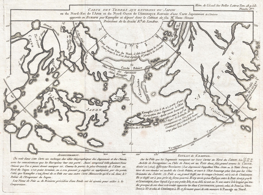
Carte Des Terres aux environs du Japon ou du Nord-Est de l'Asie et du Nord-Ouest de l'Amerique Extraite d'une Carte Japonnoise de l'univer apportee en Europe par Kaempfer et depose dans le Cabinet de feu Mr. Hans-Sloane President de la Societe Rle. de Londres.
1758 (undated) 8.5 x 11.5 in (21.59 x 29.21 cm)
1758 (undated) 8.5 x 11.5 in (21.59 x 29.21 cm)
Description
This is a rare 1758 map related to the Phillipe Buache / Robert de Vaugondy debate at the Paris Académie des Sciences over the cartographic configuration of the Pacific polar regions. This map was prepared for publication with Buache's Considerations Geographiques.
In the 1750s, European knowledge of the Arctic and the Pacific Northwest was limited to the discoveries of Vitus Bering and Aleksei Ilyich Chirikov, the supposed voyage of de Fonte, and general geographical speculation. Buache was one of these speculators. Determined to win royal patronage, Buache leveraged the unpublished work (and fame) of his deceased brother-in-law, Guillaume De L'Isle, to promote his own geographical theories, most of which blatantly pandered to the crown. The Buache system drew heavily on the unpublished De L'Isle 'sea of the west' maps, Russian discoveries, the De Fonte geography, and his own framework, which postulated a series of interconnected global mountain ranges, to argue for a navigable northwest passage. Such a passage would have been a boon to French interests in North America as a way to move valuable furs and other trade goods to the rich markets of China - trade routes then primarily controlled by Spain.
Buache fiercely defended his theories and in doing so came head to head with the more cautious cartography of Didier Robert de Vaugondy. Vaugondy was a thriving commercial cartographer and fellow member of the Académie des Sciences. His maps rejected the geographical theories, including the Sea of the West and the Northwest Passage, that Buache outlined in the Considerations Geographiques. Vaugondy also denounced the De Fonte voyages as unsubstantiated and doubtful, thereby deeply undermining Buache's theories and patronage ambitions.
The debate came to a head in a series of papers published before the Académie by both individuals, wherein historical references, geographical theories, and outright speculation were used to advocate for their own hypotheses as well as denounce one another. There was no clear victor at the time, although Buache did emerge from the debate with greater political power and influence. Ironically, the expeditions of James Cook roughly 30 years later discredited Buache's theories.
A Closer Look
Cartographically Buache based this map on a Japanese map brought to Europe by the German traveler and physician Engelbert Kaempfer (1651 - 1716). Buache used the map to support his geographical theories regarding the Northwest Passage and Sea of the West.Kaempfer-Sloane Japanese Map of the World
The Kaempfer-Sloane map was brought to Europe in manuscript from Japan in 1695 by Engelbert Kaempfer, a German traveler and physician. Hans Sloane acquired the map after Kaempfer's death. After Sloane's own death, it was liquidated at auction in London with the rest of his estate. The map illustrates Russian and Japanese knowledge of the North Atlantic. Today, it is heavily scrutinized by scholars who argue that it is likely a later compilation from European sources. At the time, it was an influential component in scholarly debates regarding the existence and location of the Northwest Passage. Buache created a variant of the map, as above, which he published in his Considerations Geographiques to support his synthesis and reconciliation of contemporaneous geographical information on the region.Buache / Robert de Vaugondy Polar Debate
The Buache / Robert de Vaugondy debate at the Paris Académie des Sciences was one of the most hotly argued geographical debates of the 18th century. The debate centered around the existence of a 'Sea of the West,' the Northwest Passage, and the veracity of the Arctic explorations of Bartholomew de Fonte.In the 1750s, European knowledge of the Arctic and the Pacific Northwest was limited to the discoveries of Vitus Bering and Aleksei Ilyich Chirikov, the supposed voyage of de Fonte, and general geographical speculation. Buache was one of these speculators. Determined to win royal patronage, Buache leveraged the unpublished work (and fame) of his deceased brother-in-law, Guillaume De L'Isle, to promote his own geographical theories, most of which blatantly pandered to the crown. The Buache system drew heavily on the unpublished De L'Isle 'sea of the west' maps, Russian discoveries, the De Fonte geography, and his own framework, which postulated a series of interconnected global mountain ranges, to argue for a navigable northwest passage. Such a passage would have been a boon to French interests in North America as a way to move valuable furs and other trade goods to the rich markets of China - trade routes then primarily controlled by Spain.
Buache fiercely defended his theories and in doing so came head to head with the more cautious cartography of Didier Robert de Vaugondy. Vaugondy was a thriving commercial cartographer and fellow member of the Académie des Sciences. His maps rejected the geographical theories, including the Sea of the West and the Northwest Passage, that Buache outlined in the Considerations Geographiques. Vaugondy also denounced the De Fonte voyages as unsubstantiated and doubtful, thereby deeply undermining Buache's theories and patronage ambitions.
The debate came to a head in a series of papers published before the Académie by both individuals, wherein historical references, geographical theories, and outright speculation were used to advocate for their own hypotheses as well as denounce one another. There was no clear victor at the time, although Buache did emerge from the debate with greater political power and influence. Ironically, the expeditions of James Cook roughly 30 years later discredited Buache's theories.
Publication History
This map was issued as map VI in the Article CXV of the Mémoires pour l'Histoire des Sciences et des Beaux Arts, published by the Académie des Sciences in November 1758. The work constitutes the presentation of Philippe Buache on the cartography of the Northwest Coast of America, Northeast Coast of Asia, and contiguous Polar Regions, as part of the greater search for a Northwest Passage. It was later republished by Robert de Vaugondy as a supplement to Denis Diderot's Encyclopédie, detailing the Buache/Vaugondy debate. Today, this map is quite rare, as are all the maps from the Considerations Geographiques.Cartographer
Phillipe Buache (February 7, 1700 - January 24, 1773) was a late 18th century French cartographer and map publisher. Buache began his cartographic career as the workshop assistant and apprentice to the important and prolific cartographer Guillaume de L'Isle. Upon De L'Isle's untimely death, Buache took over the publishing firm cementing the relationship by marrying De L'Isle's daughter. Over the years, Bauche republished many of De L'Isle's maps and charts. Buache was eventually appointed Premier Geographe du Roi, a position created-for and previously held by Guillaume de L'Isle. Buache is most respected for his introduction of hachuring as a method from displaying underwater elevation on a two dimensional map surface. Buache compiled maps based upon geographic knowledge, scholarly research, the journals of contemporary explorers and missionaries, and direct astronomical observation. Nevertheless, even in 18th century Paris geographical knowledge was severely limited - especially regarding those unexplored portions of the world, including the poles, the Pacific northwest of America, and the interior of Africa and South America. In these areas the Buache, like his primary rival Robert de Vaugondy, must be considered a speculative geographer or 'positive geographer'. Speculative geography was a genre of mapmaking that evolved in Europe, particularly Paris, in the middle to late 18th century. Cartographers in this genre would fill in unknown areas on their maps with speculations based upon their vast knowledge of cartography, personal geographical theories, and often dubious primary source material gathered by explorers and navigators. This approach, which attempted to use the known to validate the unknown, naturally engendered many rivalries. Buache's feuds with other cartographers, most specifically Didier Robert De Vaugondy, resulted in numerous conflicting papers being presented before the Academie des Sciences, of which both were members. The era of speculatively cartography effectively ended with the late 18th century explorations of Captain Cook, Jean Francois de Galaup de La Perouse, and George Vancouver. Buache was succeeded by his nephew Jean-Nicholas Buache de Neuville. More by this mapmaker...
Condition
Very good.
References
OCLC 928927439.