This item has been sold, but you can get on the Waitlist to be notified if another example becomes available, or purchase a digital scan.
1600 Matthias Quad edition of Mercator's Rare 1595 Arctic Map
Arctic-quad-1600$1,000.00

Title
Polus Arcticus sive Tractus Septentrionalis.
1600 (undated) 8.5 x 10.75 in (21.59 x 27.305 cm) 1 : 32000000
1600 (undated) 8.5 x 10.75 in (21.59 x 27.305 cm) 1 : 32000000
Description
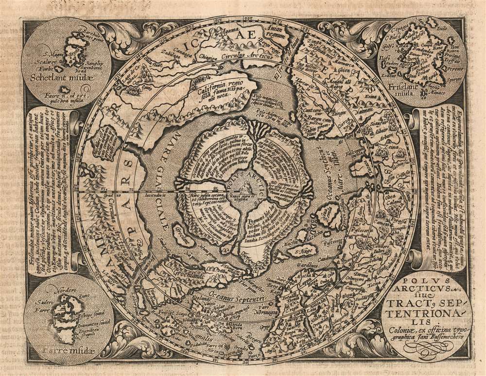
This is a scarce 1600 Matthias Quad map of the Arctic, a beautifully engraved reduction of Gerard Mercator's seminal 1595 Septentrionalium Terrarum descriptio. The timing of the engraving is of great importance: Quad's model was not the relatively ubiquitous 1606 edited version of Mercator's map, but the extremely rare 1595 first state. Although the smaller size of Quad's copperplate necessitated the excision of some place names in Greenland, Norway and Russia, the central Arctic details of the map are very faithfully preserved from the Mercator original - thus making a virtually unobtainable map's cartography available to the more casual collector. Despite the flaws of many of Mercator's sources, his map (and Quad's faithful rendition of it here) presents a fascinating portrait of the best 16th century European conceptualization of the north parts of the world.
A Keystone Map
Gerard Mercator's famous projection was a superb means of depicting regions near the equator and in temperate zones, but at the expense of grossly distorting regions close to the poles. Consequently, Mercator compensated by producing the polar projection map - first as an inset to his famous wall map, and later as the single sheet included in his 1595 Atlas which provided Quad his model.The Northern Edge of European Experience
In depicting regions so remote to European experience, Mercator had few sources upon which to draw, resulting in some of the astonishing geographical information revealed here. Mercator had derived his map's distinctive Arctic islands, its rushing rivers and maelstroms, and the North Pole's Rupes Nigra from medieval accounts of legendary Arthurian explorations, combined with the reports of 14th century Norse travelers. The mythical island of Frisland is drawn from the Zeno Map, composed in 1558 by Nicolò Zeno the Younger based on the alleged 14th century exploration of his ancestors Nicolo and Antonio Zeno. Despite the strong likelihood that the Zeno brothers never voyaged at all, Nicolò Zeno the Younger's map remained one of the only efforts to map the remote northern Atlantic available to Mercator. Frisland continued to appear on maps well into the 16th century. Details in Siberia reveal the contributions of some of the earliest western Europeans to describe Muscovy and the lands beyond. In North America, Mercator's 1595 map included details of the northern parts of America not included in his 1569 wall maps, such as the 'Lago de Conibaz' and the Arctic bay it empties into (likely sourced from Cartier, via Thevet. This is therefore one of only a handful of rarities - Mercator's Arctic, the 1575 Thevet America, and the 1593 De Jode North America - to preserve this fascinating geography.Publication History and Census
Matthias Quad engraved this map for inclusion in his Geographisch Handtbuch, published in 1600 by Johann Bussemacher in a single edition. We see twenty six examples of the book listed in OCLC; only seven copies of the separate map are so listed. While not as rare as the 1595 first state of its Mercator source, Quad's map is nevertheless an order of magnitude scarcer than the later, Hondius-edited state of Mercator's map.CartographerS
Matthias Quad (1557 - October 29, 1613) was Dutch engraver active in Cologne during the late 16th and early 17th centuries. Quad was born in the Netherlands and studied engraving under Johannes van Deutecum (fl. 1552 - 1606) of Deventer and Hendrick Goltzius (1558-1616) of Haarlem. Around 1580 he relocated to Heidelberg or Cologne where he primarily engraved geographical texts in conjunction with fellow publisher Johann Bussemacher. In 1608 he published an atlas, Fasciculus Geographicus, with Bussemacher in Cologne. In 1609, another major work, his Teutscher Nation Herligkeit, a historico-cultural regional study of Germany, was published by Wilhelm Lutzenkirchen . More by this mapmaker...
Gerard Mercator (March 5, 1512 - December 2, 1594) is a seminal figure in the history of cartography. Mercator was born near Antwerp as Gerard de Cremere in Rupelmonde. He studied Latin, mathematics, and religion in Rupelmonde before his Uncle, Gisbert, a priest, arranged for him to be sent to Hertogenbosch to study under the Brothers of the Common Life. There he was taught by the celebrated Dutch humanist Georgius Macropedius (Joris van Lanckvelt; April 1487 - July 1558). It was there that he changed him name, adapting the Latin term for 'Merchant', that is 'Mercator'. He went on to study at the University of Louvain. After some time, he left Louvain to travel extensively, but returned in 1534 to study mathematics under Gemma Frisius (1508 - 1555). He produced his first world map in 1538 - notable as being the first to represent North America stretching from the Arctic to the southern polar regions. This impressive work earned him the patronage of the Emperor Charles V, for whom along with Van der Heyden and Gemma Frisius, he constructed a terrestrial globe. He then produced an important 1541 globe - the first to offer rhumb lines. Despite growing fame and imperial patronage, Mercator was accused of heresy and in 1552. His accusations were partially due to his Protestant faith, and partly due to his travels, which aroused suspicion. After being released from prison with the support of the University of Louvain, he resumed his cartographic work. It was during this period that he became a close fried to English polymath John Dee (1527 - 1609), who arrived in Louvain in 1548, and with whom Mercator maintained a lifelong correspondence. In 1552, Mercator set himself up as a cartographer in Duisburg and began work on his revised edition of Ptolemy's Geographia. He also taught mathematics in Duisburg from 1559 to 1562. In 1564, he became the Court Cosmographer to Duke Wilhelm of Cleve. During this period, he began to perfect the novel projection for which he is best remembered. The 'Mercator Projection' was first used in 1569 for a massive world map on 18 sheets. On May 5, 1590 Mercator had a stroke which left him paralyzed on his left side. He slowly recovered but suffered frustration at his inability to continue making maps. By 1592, he recovered enough that he was able to work again but by that time he was losing his vision. He had a second stroke near the end of 1593, after which he briefly lost speech. He recovered some power of speech before a third stroke marked his end. Following Mercator's death his descendants, particularly his youngest son Rumold (1541 - December 31, 1599) completed many of his maps and in 1595, published his Atlas. Nonetheless, lacking their father's drive and genius, the firm but languished under heavy competition from Abraham Ortelius. It was not until Mercator's plates were purchased and republished (Mercator / Hondius) by Henricus Hondius II (1597 - 1651) and Jan Jansson (1588 - 1664) that his position as the preeminent cartographer of the age was re-established. Learn More...
Johann Bussemacher (fl. c. 1580 - 1613) was a German publisher, engraver, art dealer, and bookseller active in Cologne in the late 16th and early 17th centuries. He was trained as a copper engraver in Dusseldorf, where he was born. Around in 1583 he established his own imprint and a publishing concern in Cologne. Bussemacher was for a time the largest and most successful publisher in Cologne. He is commonly associated with producing engraved images of saints and noble personages, but he also issued several maps in conjunction with Matthias Quad. Learn More...
Source
Quad, M. Geographisch Handtbuch(Cologne: Bussemacher) 1600.
Condition
Very good. Small infill in upper margin not impacting printed image; some text showthrough as usual; else excellent.
References
OCLC 611353466. Rumsey 9690.162.