1952 Pictorial Tourist Map of Route 66 in Arizona, Printed on a Napkin
Arizona-bestops-1952-3$300.00

Title
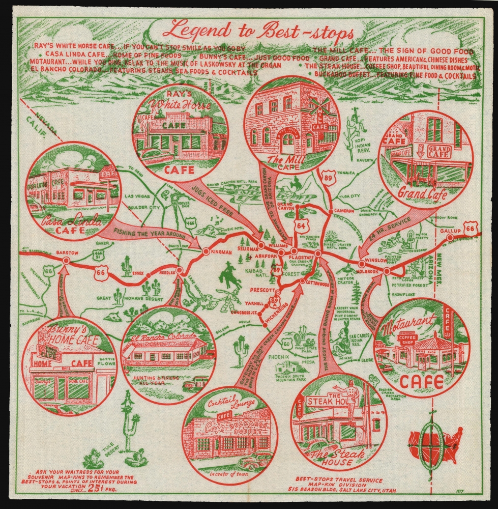
Legend to Best-Stops.
1952 (undated) 13 x 13 in (33.02 x 33.02 cm)
1952 (undated) 13 x 13 in (33.02 x 33.02 cm)
Description
This is a 1952 map of northern Arizona, printed in two colors on a diner napkin. This 'Mapkin', produced by the Best Stops Travel Service of Salt Lake City, Utah, represents a pictorial icon of the pre-interstate Arizona road trip, focusing specifically on the region along the fabled Route 66 from Gallup, New Mexico to Barstow California. The region covered runs from Phoenix, Arizona in the south, up to the Grand Canyon in the north. This was an area that BestOPS had covered in 1948; the present work not only features different restaurants, but also sharpens the focus on Route 66 as the major corridor of the region.
The probable man behind BestOPS, Dorius Ether Black, appears to have traveled widely in the American west as a member of the Latter Day Saints, and to have been intimately familiar with the roadside food options from New Mexico to Idaho. BestOPS (or by the time this piece was composed, Best-Stops) changed their format and printing techniques shortly after 1951 as a result of the company having been bought from Black by Salt Lake City jeweler Lincoln Carter White. These changes (compared with others of the company's maps) can help in our dating, along with the map's content. Most Map-kins are numbered. This one is numbered #107; we have dated number #103 to 1952, supporting the content-based assessment of an early date of 1952. By 1955, Black had relocated to Florida and was working as a salesman there, and Best-Stops does not seem to have produced any new work after that.
Get Your Kicks On...
Route 66 - variously known as the Will Rogers Highway, the Mother Road, and The Main Street of America - features prominently in red, highlighting the Arizona towns of Holbrook, Winslow, Flagstaff, Seligman, Kingman, Needles California, and Barstow. Likewise, in red, U.S. Route 89 is shown connecting Phoenix to Route 66 at Ashfork, while Route 64 connects further to the Grand Canyon. U. S. Route 60 runs along the southern border of the map, but it is not as prominently featured, being printed in green. Throughout this area are interspersed a charming array of iconic travelers' destinations - historical sites and monuments, natural landmarks, and recommendable eateries to support the hungry tourists en route.The Business At Hand
The 'mapkins' were intended as advertising works, not nostalgia pieces, so consequently the businesses named on it were ones that were in operation at the time. Ray's White Horse Cafe of Seligman in 1948 been run by 'Jackie and Eddie' (praised on the 1948 map) but then had sold to a 'Mrs. Leo King' in 1950; by 1952 ownership had passed to Raymond Thomas, and this supports a date no earlier than 1952. Bunny's Home Cafe in Barstow would close for good in 1960, and certainly this would not have been published after that, but we see no newspaper advertisements in Barstow at all after 1954. A note about the restaurant in a 1952 Barstow paper comments on the cafe's attractive dessert napkins, however, and this is compelling evidence. In Flagstaff, The Steak House would change ownership and reopen in 1954 as Grant's Steak House; the name appearing here suggests a date prior to that change. El Ranch Colorado in Needles appears in no newspaper reference after 1955, and probably changed names or closed around then. Other locales - such as Cottonwood's Buckaroo Buffet and Cocktail Lounge - do not appear in newspaper records, and their name survives only here.Natural Wonders
The Grand Canyon forms the northern border of the map, but it is not alone in depicting the natural wonders to be found. The Kaibab Forest appears near the middle of the map, which also shows the Sunset Crater, and the Mojave Desert.Native American Features
American tourists were drawn by the scenery, but also by the exoticism of the people within it; dating back to the Harvey Houses of the late 19th and early 20th century, the Native Americans of the southwest were a reliable tourist draw. The Mapkin features the San Carlos Indian reservation. In a note of humor that fails today, the Hopi Indian Reservation is marked with a cartoonish Indian on a pogo stick.Other Historic Sites
In the upper left, the modern marvel of Hoover Dam holds back Lake Mead. Phoenix South Mountain Park is shown as well.The probable man behind BestOPS, Dorius Ether Black, appears to have traveled widely in the American west as a member of the Latter Day Saints, and to have been intimately familiar with the roadside food options from New Mexico to Idaho. BestOPS (or by the time this piece was composed, Best-Stops) changed their format and printing techniques shortly after 1951 as a result of the company having been bought from Black by Salt Lake City jeweler Lincoln Carter White. These changes (compared with others of the company's maps) can help in our dating, along with the map's content. Most Map-kins are numbered. This one is numbered #107; we have dated number #103 to 1952, supporting the content-based assessment of an early date of 1952. By 1955, Black had relocated to Florida and was working as a salesman there, and Best-Stops does not seem to have produced any new work after that.
Publication History and Census
The mapkin was printed, using a halftone process, by the Best Stops Travel Service Map-kin division of Salt Lake City, Utah. The firm appears in the Salt Lake City directories of 1951 and 1952 under its two consecutive business names (BestOPS and Best Stops; that this example - number 107 - bears the latter trade name tends to support the later date. Only one of a possible 143 mapkins is listed OCLC (the 1948 map covering this specific region), and a sole example of Mapkin 106 is held by the Library of Congress. Given the purpose and general life expectancy of the diner napkin, as a form, the scarcity of these objects is perhaps unsurprising.Cartographer
BestOPS (fl. 1948-1952), a.k.a. Best Stops Travel Service, was an American map-centered advertising company that arrived, and vanished, in the period following World War II (1939 - 1945) but preceding the c. 1955 explosion of the Interstate Highway System. The company's sole apparent product was a series of maps printed on diner napkins - hence, Mapkins - intended to promote roadside restaurants and cafes along the scenic routes to America's national parks and wonders. Thus the mapkins capture the moment in American automotive history in which newly prosperous families took to the roads and ate their way across America, one diner at a time.
The company's address - always printed on the Mapkin - appears briefly to have been in Portland, Oregon but then to have relocated to Utah. A few show an address in Provo, but the majority we have identified show one of several addresses in Salt Lake City; after 1951, mainly in the Beason Building. Most of the Mapkins can be dated, with reasonable confidence, based on the rapidly-changing landscape of the restaurant trade. Our research suggests that most were printed between 1948 and 1952.
The Salt Lake City directories of 1951 and 1952 are illuminating. The '51 directory includes an entry for BestOPS Travel Service, naming a Dorius E. Black as manager. In 1952, the directory names instead 'Best Stops Travel Service;' Black is listed as Vice President and Sales Manager, with its president listed as Lincoln C. White. Lincoln Carter White (1919 - 1986) was a successful Salt Lake City jeweler, who had offices in the Beason Building that correspond to the address found on Mapkins after 1951. We suspect White not to have been the creator of the Mapkins, but an investor.
Dorius Ether Black (March 15, 1918 - June 29, 1985) is a better candidate. Before his wartime service in the navy reserves, he had travelled abroad as a missionary. We see no indication of his profession between 1946 and 1950; The 1950 Census listed him as separated, and living in Provo with his mother and siblings. His profession was listed as a salesman with 'Travel Service,' with two younger sisters working as stenographers for the same. Up until 1951, BestOPS Travel Service operated via post office box addresses, in Provo, Salt Lake City, and briefly in Portland, Oregon. We suspect that Black started BestOPS and ran it out of his mother's house, with the assistance of his sisters, while he travelled around the country selling his mapkins to various diners en route. As a LDS missionary, he may well have been traveling as a proselytizer at the same time. In 1951 or 1952, he sold the business, or a share of it, to White: perhaps with an eye to providing a home for his fiancee, whom he would marry in 1952. White's involvement brought changes: more industrial printing methods, slicker branding, and a less-confusing business name - while as Vice President and Sales Manager, Black continued to travel and work his sales contacts. But before long, his travels for Best Stops brought him to Florida, and he decided to stay there - first in St. Petersburg, where he would begin work for a brokerage, and then to Orlando. Without Black, Best Stops appears to have ceased producing new Mapkins. White seems to have kept the business until it was struck from the Utah tax rolls in November 9, 1973, but while it appears likely that Best Stops would have continued trying to sell its back stock, we have seen no Mapkin that could credibly have been made any later than 1952 or 53.
We would like to extend our gratitude to Doug Misner, Library and Collections Manager of the Utah Historical Society, for his crucial assistance in identifying the individuals behind these fascinating pieces of cartographic Americana. More by this mapmaker...
Condition
Very good. Original folds present. No soup.