This item has been sold, but you can get on the Waitlist to be notified if another example becomes available, or purchase a digital scan.
1948 Pictorial Tourist Map of Northwest Arizona Printed on a Napkin
ArizonaMapkin-bestops-1948$100.00

Title
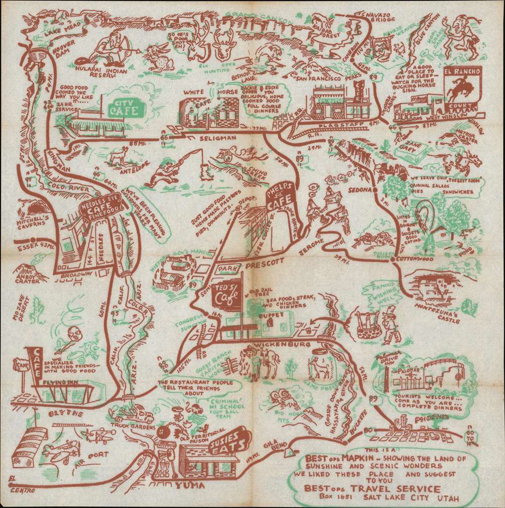
This Is A BESTops MAPKIN - Showing The Land of Sunshine and Scenic Wonders We Liked These Place and Suggest To You. BESTops Travel Service Box 1651 Salt Lake City Utah.
1948 (undated) 13 x 12.25 in (33.02 x 31.115 cm)
1948 (undated) 13 x 12.25 in (33.02 x 31.115 cm)
Description
A rare survival: a 1948 map of northwestern Arizona, printed in two colors on a diner napkin. This 'Mapkin' represesnts a pictorial icon of the pre-interstate Arizona road trip, focusing specifically on the region encompassed by Yuma and Phoenix, Arizona in the south, up to the Grand Canyon in the north.
Get Your Kicks On...
Route 66 - variously known as the Will Rogers Highway, the Mother Road, and The Main Street of America features prominently, highlighting the Arizona towns of Winslow, Flagstaff, Seligman, Kingman, and Needles, California. U. S. Route 80, also known as the Broadway of America and the Ocean to Ocean highway, forms the southern border of the map. U.S. Route 89, running from Phoenix Flagstaff, makes one connection between the two great roads. Throughout this area are interspersed a charming array of iconic travelers' destinations - historical sites and monuments, natural landmarks, and recommendable eateries to support the hungry tourists en route from each to the other.The Business At Hand
The 'mapkin' was intended as an advertising work, not a nostalgia piece, so consequently the businesses named on it were ones that were in operation at the time. Therefore, despite the piece's lack of a date, we can make an estimation based on its content. Flagstaff, Arizona's 'El Patio' café opened in 1948; a date much earlier than this appears unlikely. The White Horse Cafe of Seligman went up for sale in 1947, reopening in 1950 under different ownership than the 'Jackie and Eddie' praised on the map, suggesting a date no later than 1949. The Needle's Eye Cafe suffered the loss of owner/operator Rosalind Swanson in 1947, and it seems unlikely to have long survived that blow; between that, and the presence in Sedona of the 'Rainbow's End Café' (opened 1948) we are confident in positing a publication date of 1948 for this piece. Many of the other attractions shown here were similarly short-lived: El Rancho Court in Winslow had opened in 1947 only to sell, and reopen as Flamingo in 1954. Yuma's 'Susie's Eats' may have opened sooner, but was advertising 24-hour service in 1946; it was still in operation as late as 1950. Wickenburg's 'Ted's Cafe' ran newspaper ads assiduously from 1945 to 1948. A notable exception to this parade of culinary ephemera was the venerable 'City Cafe' on Route 66 in Kingman: opening in 1939, it remained a going concern until the turn of this century, when it was renamed Hot Rod Cafe (alas, closing in 2008 to be replaced, we hear, by a Walgreens. Sic Transit Gloria Mundi.)Natural Wonders
the Grand Canyon forms the northern border of the map, but it is not alone in depicting the natural wonders to be found. The Colorado River winds down the left-hand part of the map, which also shows Mitchell's Caverns, Amboy crater, and the Mojave Desert. The meteor crater is shown as well as the Big Horn Mountains between Phoenix and Yuma.Native American Features
American tourists were drawn by the scenery, but also by the exoticism of the people within it; dating back to the Harvey Houses of the late 19th and early 20th century, the Native Americans of the southwest were a reliable tourist draw. The Mapkin features the Hulapai Indian reservation, a depiction of a Navajo weaver and a Hopi snake dancer; the Tuzigoot pueblo and the misnamed 'Montezuma's Castle' also appear.Other Historic Sites
In Prescott along Route 89 the Historic Governor's Mansion - now the Sharlot Hall museum - appears prominently. The old Territorial Prison is named in Yuma. Blythe Airport - during World War Two a training base - is shown in the lower left. In the upper left, the modern marvel of Hoover Dam holds back Lake Mead (in which a fish jumps.)Publication History and Census
The mapkin was, it tells us, produced by the BESTops Travel Service of Salt Lake City, Utah. Apart from the November 9, 1973 notice in the Salt Lake Times of the business' suspension by the Utah State Tax Commission, we are unable to find any evidence of this firm beyond its output, which primarily focused on the American Southwest. A single example of a mapkin, one of New Mexico, is listed in OCLC. Given the purpose and general life expectancy of the diner napkin, as a form, the scarcity of these objects is perhaps unsurprising.Cartographer
BestOPS (fl. 1948-1952), a.k.a. Best Stops Travel Service, was an American map-centered advertising company that arrived, and vanished, in the period following World War II (1939 - 1945) but preceding the c. 1955 explosion of the Interstate Highway System. The company's sole apparent product was a series of maps printed on diner napkins - hence, Mapkins - intended to promote roadside restaurants and cafes along the scenic routes to America's national parks and wonders. Thus the mapkins capture the moment in American automotive history in which newly prosperous families took to the roads and ate their way across America, one diner at a time.
The company's address - always printed on the Mapkin - appears briefly to have been in Portland, Oregon but then to have relocated to Utah. A few show an address in Provo, but the majority we have identified show one of several addresses in Salt Lake City; after 1951, mainly in the Beason Building. Most of the Mapkins can be dated, with reasonable confidence, based on the rapidly-changing landscape of the restaurant trade. Our research suggests that most were printed between 1948 and 1952.
The Salt Lake City directories of 1951 and 1952 are illuminating. The '51 directory includes an entry for BestOPS Travel Service, naming a Dorius E. Black as manager. In 1952, the directory names instead 'Best Stops Travel Service;' Black is listed as Vice President and Sales Manager, with its president listed as Lincoln C. White. Lincoln Carter White (1919 - 1986) was a successful Salt Lake City jeweler, who had offices in the Beason Building that correspond to the address found on Mapkins after 1951. We suspect White not to have been the creator of the Mapkins, but an investor.
Dorius Ether Black (March 15, 1918 - June 29, 1985) is a better candidate. Before his wartime service in the navy reserves, he had travelled abroad as a missionary. We see no indication of his profession between 1946 and 1950; The 1950 Census listed him as separated, and living in Provo with his mother and siblings. His profession was listed as a salesman with 'Travel Service,' with two younger sisters working as stenographers for the same. Up until 1951, BestOPS Travel Service operated via post office box addresses, in Provo, Salt Lake City, and briefly in Portland, Oregon. We suspect that Black started BestOPS and ran it out of his mother's house, with the assistance of his sisters, while he travelled around the country selling his mapkins to various diners en route. As a LDS missionary, he may well have been traveling as a proselytizer at the same time. In 1951 or 1952, he sold the business, or a share of it, to White: perhaps with an eye to providing a home for his fiancee, whom he would marry in 1952. White's involvement brought changes: more industrial printing methods, slicker branding, and a less-confusing business name - while as Vice President and Sales Manager, Black continued to travel and work his sales contacts. But before long, his travels for Best Stops brought him to Florida, and he decided to stay there - first in St. Petersburg, where he would begin work for a brokerage, and then to Orlando. Without Black, Best Stops appears to have ceased producing new Mapkins. White seems to have kept the business until it was struck from the Utah tax rolls in November 9, 1973, but while it appears likely that Best Stops would have continued trying to sell its back stock, we have seen no Mapkin that could credibly have been made any later than 1952 or 53.
We would like to extend our gratitude to Doug Misner, Library and Collections Manager of the Utah Historical Society, for his crucial assistance in identifying the individuals behind these fascinating pieces of cartographic Americana. More by this mapmaker...
Condition
Very good condition. Toned along fold. No soup.
References
Not in OCLC.