1846 Bradford Map of Arkansas
Arkansas-bradford-1846$300.00

Title
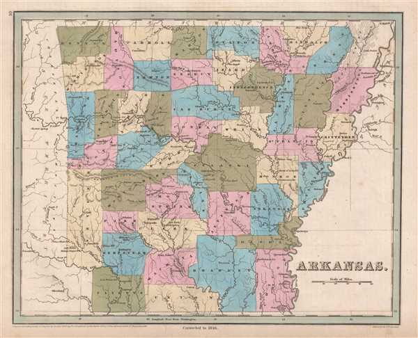
Arkansas.
1846 (dated) 12.25 x 14.75 in (31.115 x 37.465 cm) 1 : 1480000
1846 (dated) 12.25 x 14.75 in (31.115 x 37.465 cm) 1 : 1480000
Description
This is an 1846 Thomas G. Bradford map of Arkansas. The map depicts the region from Oklahoma, labeled here as the 'Missouri Territory', to the Mississippi River, Tennessee, and an unlabeled portion of northern Mississippi, and from Missouri to the Arkansas-Louisiana state line. Counties are illustrated, labeled, and shaded different colors to allow for easy differentiation. Towns and villages are labeled throughout the state are labeled, with Bradford stating, 'Arkansas contains no considerable towns or even villages, the small population being chiefly distributed in scattered settlements'. A highly detailed, yet sparse map, Bradford renders explicitly apparent the lack of urbanization and modern methods of transportation in the state. Railroads and canals are not present, as none had been built in Arkansas at the time. As Arkansas was only admitted into the Union in 1836, it neither had the population centers or the industry to drive the construction of these forms of transportation.
Slavery was a major point of contention when Arkansas petitioned the Federal government for statehood. Geography played an outsize role in the debate over slavery in Arkansas, as owners of cotton plantations in southeastern Arkansas strongly supported the 'peculiar institution', while those surviving on subsistence farming in northwest Arkansas, the 'hill country', opposed slavery. Debate over Arkansas's constitution lasted for twenty-five hours, when finally the decision was made to admit Arkansas as the twenty-fifth state and the thirteenth slave state on June 15, 1836.
This map was engraved by George Boynton and published in the 1846 edition of Bradford and Goodrich's A Universal Illustrated Atlas.
CartographerS
Thomas Gamaliel Bradford (1802 - 1887) was born in Boston, Massachusetts, where he worked as an assistant editor for the Encyclopedia Americana. Bradford's first major cartographic work was his revision and subsequent republishing of an important French geography by Adrian Balbi, Abrege de Geographie published in America as Atlas Designed to Illustrate the Abridgment of Universal Geography, Modern and Ancient. Afterwards Bradford revised and expanded this work into his own important contributions to American cartography, the 1838 An Illustrated Atlas Geographical, Statistical and Historical of the United States and Adjacent Countries. Bradford's cartographic work is significant as among the first to record Texas as an independent nation. In his long career as a map publisher Bradford worked with William Davis Ticknor of Boston, Freeman Hunt of New York, Charles De Silver of Philadelphia, John Hinton, George Washington Boynton, and others. We have been able to discover little of Bradford's personal life. More by this mapmaker...
George Washington Boynton (fl. c. 1830 - 1850) was a Boston based cartographer and map engraver active in the first half of the 19th century. Boynton engraved and compiled maps for numerous publishers including Thomas Bradford, Nathaniel Dearborn, Daniel Adams, and S. G. Goodrich. His most significant work is most likely his engraving of various maps for Bradford's Illustrated Atlas, Geographical, Statistical, and Historical, of the United States and the Adjacent Countries and Universal Illustrated Atlas. He also engraved for the Boston Almanac. In 1835, Boynton is listed as an employee of the Boston Bewick Company, an engraving, stereotype, and printing concern based at no. 47 Court Street, Boston. Little else is known of his life. Learn More...
Source
Bradford, T. G. and Goodrich, S. G., A Universal Illustrated Atlas, exhibiting a Geographical, Statistical, and Historical view of the World, (Boston: Charles D. Strong) 1846.
The Universal Illustrated Atlas is one of the great American atlases of the first half of the 19th century. The atlas was first published in 1838 under the imprint of Charles D. Strong. It replaced and superseded Bradford's earlier smaller format Illustrated Atlas, Geographical, Statistical, and Historical, of the United States and the Adjacent Countries. Numerous reissues of the Universal Illustrated Atlas followed until about 1848. Although there are minor variations between the editions, most contain about 50 maps, the majority of which focus on the United States. Bradford's atlases are significant for recording North America during the Republic of Texas Era. In later editions, particularly the 1846 edition, Bradford illustrates the boom in railroad construction, possibly with the idea that his maps would aid travelers in planning journeys by rail. It was compiled by Thomas Gamaliel Bradford and Samuel Griswold Goodrich with most of the plates engraved by George Washington Boynton (fl. c. 1830 - 1850). Other contributors include Thomas Gordon (1778 - 1848), Fielding Lucas Jr. (1781 - 1854), Samuel Edward Stiles (1844 - 1901), Sherman and Smith (fl. c. 1829 - 1855), and Horace Thayer (1811 - c. 1874).
Condition
Very good. Even overall toning. Blank on verso.
References
Rumsey 0089.035 (1838 edition).