1849 Greenleaf Map of Arkansas
Arkansas-greenleaf-1849$300.00

Title
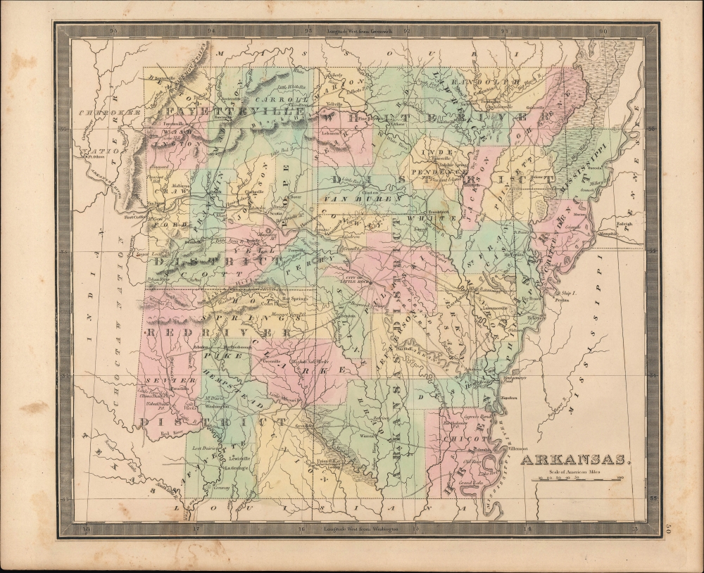
Arkansas.
1849 (undated) 10.75 x 12.5 in (27.305 x 31.75 cm) 1 : 1700000
1849 (undated) 10.75 x 12.5 in (27.305 x 31.75 cm) 1 : 1700000
Description
An example of Jeremiah Greenleaf's 1849 map of Arkansas, published in his New Universal Atlas, depicting the state soon after its ascension to the Union.
Hot Springs, at left, had only been discovered by non-native Americans in 1804 but quickly developed into a resort for convalescents and tourists. In 1832, the lands around the spring were designated as a reservation by the U.S. Congress, the first instance of the federal government protecting lands and an important precursor to the National Park system.
Arkansas, and particularly the state's southwest, was also important in the years prior to this map's publication as a conduit for migrants, goods, and weapons to Texas, and it has been proposed by at least some historians that Sam Houston and his comrades may have first discussed plans for the Texas Revolution in a tavern in the town of Washington in 1834.
A Closer Look
Greenleaf depicts the new state with color-coding at the county level, waterways, towns, roads, swamps, mountains, salt works, sulfur springs, and other features noted throughout. Black dashed lines outline the state's land districts (Helena, White River, Fayetteville, Red River, and Arkansas), each of which contained a land office tasked with surveying the lands therein.Hot Springs, at left, had only been discovered by non-native Americans in 1804 but quickly developed into a resort for convalescents and tourists. In 1832, the lands around the spring were designated as a reservation by the U.S. Congress, the first instance of the federal government protecting lands and an important precursor to the National Park system.
Historical Context
This map was produced soon after Arkansas joined the Union in 1836. The preceding years had been tumultuous, with large-scale immigration and the confinement or removal of Native Americans. The issue of slavery was also deeply divisive during Arkansas' territorial and early statehood period, with wealthy plantation owners in the southeast strongly favoring it and small-scale farmers in the northwest (including a population of free Black farmers) being indifferent or opposed to slavery. As was the case nationally, the question of slavery also had implications for political representation, and a solution similar to the Three-Fifths Compromise in the U.S. Constitution was brokered at the state level.Arkansas, and particularly the state's southwest, was also important in the years prior to this map's publication as a conduit for migrants, goods, and weapons to Texas, and it has been proposed by at least some historians that Sam Houston and his comrades may have first discussed plans for the Texas Revolution in a tavern in the town of Washington in 1834.
Publication History and Census
This map was published by Jeremiah Greenleaf in the scarce 1849 (last) edition of his New Universal Atlas. It is based on David Burr's 1835 original, which was published in the latter's atlas of the same name, before being inherited and updated by Greenleaf, who published it in several editions in the 1840s.CartographerS
Jeremiah Greenleaf (1791 - 1864) is a little known but highly admired American cartographer of the early 19th century. He published from roughly 1830 to 1850. His most important work is A New Universal Atlas; Comprising of all the Principal Empires, Kingdoms, and States Throughout the World and Forming a distinct Atlas of the United States, published in several editions in the 1840s. Many of his maps are reformatted versions of his contemporary David Burr's much admired cartographic works. Greenleaf's maps are extremely rare and admired for their stunningly vivid pastel color washes. More by this mapmaker...
David Hugh Burr (August 18, 1803 - December 25, 1875) of one of the first and most important truly American cartographers and map publishers. Burr was born in Bridgeport Connecticut in August of 1803. In 1822 Burr moved to Kingsboro, New York to study law. A year and a half later he was admitted to the New York Bar association. Burr must have questioned his choice of careers because shortly after being admitted to the Bar, he joined the New York State Militia. Though largely untrained in the art of surveying, Burr was assigned to work under Surveyor General of New York, Simeon De Witt, to survey several New York Roadways. Seeing a window of opportunity, Burr was able to negotiate with the governor of New York at the time, De Witt Clinton, to obtain copies of other New York survey work in order to compile a map and Atlas of the state of New York. Recognizing the need for quality survey work of its territory, the government of New York heartily endorsed and financed Burr's efforts. The resulting 1829 Atlas of the State of New York was the second atlas of an individual U.S. state and one of the most important state atlases ever produced. Burr went on to issue other maps both of New York and of the United States in general. In cooperation with publishing firm of Illman & Pillbrow, he produced an important New Universal Atlas and, with J.H. Colton, several very important maps of New York City. In recognition of this work, Burr was appointed both "Topographer to the Post office" and "Geographer to the House of Representatives of the United States". Later, in 1855, Burr was assigned to the newly created position of Surveyor General to the State of Utah. Burr retired from the position and from cartographic work in general in 1857 when light of some of his financial misdeeds and frauds came to light. He was accused of submitting false expense reports and underpaying employees, among other indiscretions. Learn More...
Source
Greenleaf, J., New Universal Atlas, (Brattleboro, Vermont: Greenleaf) 1849.
Condition
Good. Sporadic foxing.
References
Rumsey 15176.054.