1854 Mitchell Map of Arkansas
Arkansas2-mitchell-1854$225.00

Title
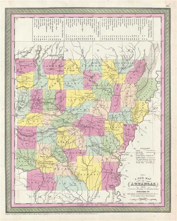
A New Map of Arkansas with its Canals, Roads, and Distances.
1854 (dated 1850) 15 x 12 in (38.1 x 30.48 cm) 1 : 1700000
1854 (dated 1850) 15 x 12 in (38.1 x 30.48 cm) 1 : 1700000
Description
This is an 1854 Thomas Cowperthwait and S. A. Mitchell map of Arkansas. The map depicts the state from Missouri to Louisiana and from the Indian Territory to Mississippi and Tennessee. Numerous cities and towns are labeled, including Little Rock and Pine Bluff. Roads, rivers, and flood plains are also illustrated. The whole is engraved and colored in Mitchell's distinctive style with green border work and vivid pastels. Counties and topographical features are noted and color coded with elevation rendered by hachure. Along the upper border Steam Boat routes along with distances are presented in tabular format.
This map was prepared by S. A. Mitchell for publication by the Philadelphia firm of Thomas Cowperthwait & Co. as plate no. 26 in the 1854 edition of Mitchell's New General Atlas. Dated and copyrighted, 'Entered according to act of Congress in the year 1850 by Thomas Cowperthwait & Co. in the Clerk's office of the Eastern District of Pennsylvania.'
This map was prepared by S. A. Mitchell for publication by the Philadelphia firm of Thomas Cowperthwait & Co. as plate no. 26 in the 1854 edition of Mitchell's New General Atlas. Dated and copyrighted, 'Entered according to act of Congress in the year 1850 by Thomas Cowperthwait & Co. in the Clerk's office of the Eastern District of Pennsylvania.'
Cartographer
Samuel Augustus Mitchell (March 20, 1792 - December 20, 1868) began his map publishing career in the early 1830s. Mitchell was born in Bristol, Connecticut. He relocated to Philadelphia in 1821. Having worked as a school teacher and a geographical writer, Mitchell was frustrated with the low quality and inaccuracy of school texts of the period. His first maps were an attempt to rectify this problem. In the next 20 years Mitchell would become the most prominent American map publisher of the mid-19th century. Mitchell worked with prominent engravers J. H. Young, H. S. Tanner, and H. N. Burroughs before attaining the full copyright on his maps in 1847. In 1849 Mitchell either partnered with or sold his plates to Thomas, Cowperthwait and Company who continued to publish the Mitchell's Universal Atlas. By about 1856 most of the Mitchell plates and copyrights were acquired by Charles Desilver who continued to publish the maps, many with modified borders and color schemes, until Mitchell's son, Samuel Augustus Mitchell Junior, entered the picture. In 1859, S.A. Mitchell Jr. purchased most of the plates back from Desilver and introduced his own floral motif border. From 1860 on, he published his own editions of the New General Atlas. The younger Mitchell became as prominent as his father, publishing maps and atlases until 1887, when most of the copyrights were again sold and the Mitchell firm closed its doors for the final time. More by this mapmaker...
Source
Mitchell, S. A., A New Universal Atlas Containing Maps of the various Empires, Kingdoms, States and Republics Of The World, (Thomas Cowperthwait and Co., Philadelphia) 1854.
Condition
Very good. Overall toning. Light soiling along margins. Margin tear professionally repaired on verso. Blank on verso.
References
Rumsey 0537.000 (1846 edition). Phillips (Atlases) 814.