This item has been sold, but you can get on the Waitlist to be notified if another example becomes available, or purchase a digital scan.
1875 Italian Map of Armenia and Kurdistan (Predates Armenian Genocide)
ArmeniaKurdistan-baroffio-1875$750.00


Title
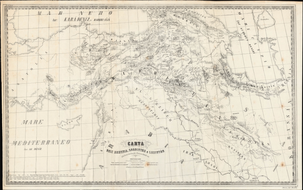
Carta dell'Armenia, Kurdistan e Lazistán della Russia meridionale e Persia occidentale ecc.
1875 (undated) 19.5 x 31 in (49.53 x 78.74 cm) 1 : 3000000
1875 (undated) 19.5 x 31 in (49.53 x 78.74 cm) 1 : 3000000
Description
An unrecorded c. 1875 A. Nodari and A. de Bianchi map of the Kurdistan, Armenia, and the Caucuses. This previously unknown map may be considered the earliest known map of specifically of Kurdistan. It emerged during a period of rising ethnic and cultural division among Kurds and Armenians in the context of persistent Russian expansionism into the Caucuses and towards the Mediterranean, culminating in the Russo-Turkish War (1877 - 1878), the postwar Ottoman drive to assimilate Kurds, and events such as the Hamidian Massacres presaging the Armenian Genocide.
Italians at the time were keenly interested in events further east. They saw the Russo-Turkish War as a Russian push not only into Ottoman Empire, but into the Mediterranean and their own territorial sphere. After all, the Russian goal was to secure both the Bosporus and the Dardanelles, thus offering the Imperial Navy warm water access to the Mediterranean. Although Armenia and Kurdistan may have been far-off battlefields, seen in the context of broader Russian expansionism, they became a subject of international interest.
A Closer Look
Centered on Lake Van, the map focuses detail on the traditional extent of Kurdistan and to a lesser extent Armenia. Coverage ranges from the Caucasus in the north to the Persian Gulf in the south, and from Istanbul (Constantinople) and the Mediterranean in the west to Khorasan (eastern Persia) in the east. It also highlights neighboring regions, including Lazistan, a coastal region on the border between Turkey and Georgia. It this incorporates parts of modern day Eastern Turkey, Iraq, Syria, Armenia, Georgia, Azerbaijan, and Iran (Persia). Significantly, no physical borders are defined, underscoring both how little this area was understood cartographically and the degree to which it was contested between internal and external powers. Elevation and waterways are prominently illustrated throughout. Cities and towns are noted, often with their names in other languages in parentheses. Most often, these are names known to Europeans through the Romans, but not in all cases. For example, the alternative Turkish name for Diarberkir [Diyarbakır] of Kara-Amid is given in parentheses. The Turkish names for the Black Sea (Karadeniz), Mediterranean (Akdeniz), and Caspian Sea (Kuzgun Denizi) are similarly given. Region names and ethnic groups are also recorded, such as 'Drusi e Maruniti' in Lebanon. A glossary at bottom-left lists transliterated Turkish words and their Italian equivalents.Historical Context
This map is contextualized by the rise of ethnic nationalism and general regional destabilization in the lead-up to the Russo-Turkish War (1877 - 1878). Until the late 19th century, both Kurds and Armenians maintained a degree of autonomy within the Ottoman Empire. With significantly overlapping territory, Kurds and Armenians had long maintained peaceful relations, with intermarriage, trade, and cultural exchange common. Nonetheless, from the mid-19th century Armenians, as non-Muslims, were increasingly marginalized and discriminated against by the Ottoman hegemony. Russia was then pushing aggressively into Caucuses. In the decades prior, Russia secured sovereignty over parts of Armenia, Georgia, and the Trans-Caucasia. Armenians began to see Imperial Russia as a potential ally and protector against the Ottomans. At the same time, Muslim Kurds became more closely aligned with the Ottoman Empire. This brought about increased animosity between the overlapping groups, especially following the Kurdish involvement violent Ottoman suppressions of perceived Russian-allied Armenian communities.Italians at the time were keenly interested in events further east. They saw the Russo-Turkish War as a Russian push not only into Ottoman Empire, but into the Mediterranean and their own territorial sphere. After all, the Russian goal was to secure both the Bosporus and the Dardanelles, thus offering the Imperial Navy warm water access to the Mediterranean. Although Armenia and Kurdistan may have been far-off battlefields, seen in the context of broader Russian expansionism, they became a subject of international interest.
Publication History and Census
This map was drawn by A. Nodari and A. de Bianchi, about whom we can find no further information, and was printed by Litografia de Gaetano Baroffio in Milan. It is undated, but from the style and known information about Baroffio likely dates to the late 1860s to mid-1870s. We have been unable to find any other examples of the map in institutional collections or on the market.Cartographer
Litografia de Gaetano Baroffio (fl. c. 1860 - 1876) was a lithographer and map publisher based in Milan. Little is known about Baroffio; a man by that name, who was known to be a provincial delegate and knight of the Austrian Empire, died in 1897 and was renowned as a prominent philanthropist in Milan, but it is unclear if this is the same Gaetano Baroffio who ran the lithographic print shop. As for the business, like many lithographers, it appears to have started out with smaller items like calendrical cards before moving on to book plates and maps. More by this mapmaker...
Condition
Good. Some soiling. Light wear on original folds.