This item has been sold, but you can get on the Waitlist to be notified if another example becomes available, or purchase a digital scan.
1858 Kiepert Map of Armenia, Kurdistan and Azerbaijan
ArmeniaKurdistan-kiepert-1858$750.00

Title
Karte von Armenien, Kurdistan und Azerbeidschan in vier blatt im Anschluss an die IV westlichen und mittleren Blätter der Karte von Klein-Asien, entworfen und bearbeitet 1852-55.
1858 (dated) 28.25 x 43.5 in (71.755 x 110.49 cm) 1 : 1000000
1858 (dated) 28.25 x 43.5 in (71.755 x 110.49 cm) 1 : 1000000
Description
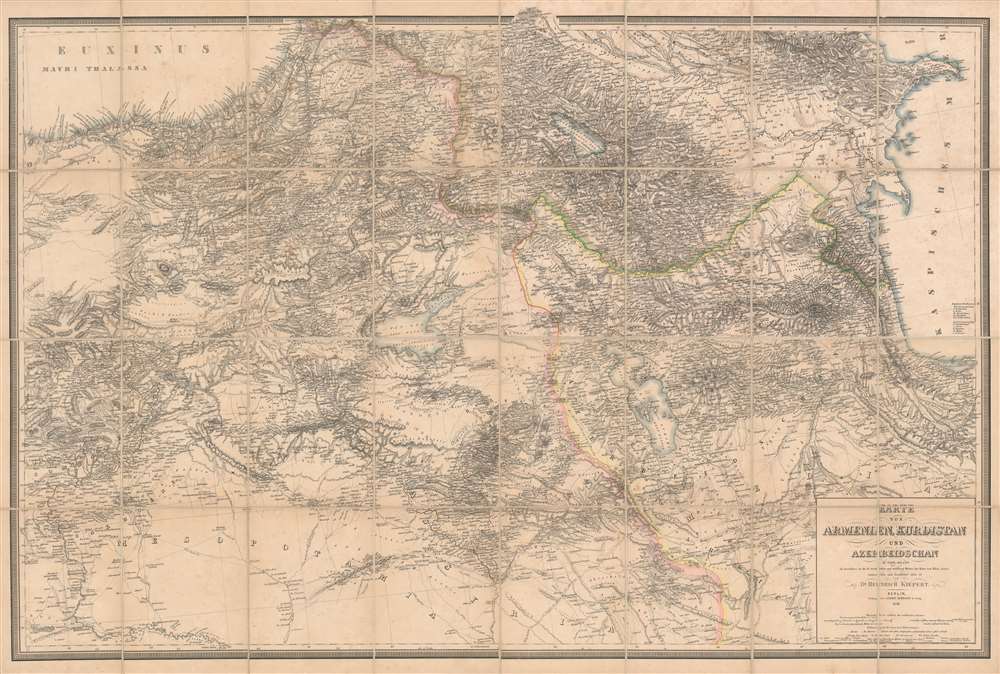
A seminal production, this is Heinrich Kiepert's 1858 map of Armenia, Kurdistan, and Azerbaijan, the definitive map of the region for more than 50 years. This map was used for treaty negotiation, military activity, and administration. In order to create it, Kiepert travelled the region many times - constantly sketching maps. His own observations were supplemented by diligent scholarship, resulting in a deep understanding local exploratory history and earlier survey work - note how throughout are noted, and dated, the tracks of earlier voyagers. The result is the finest area map available for most of the second half of the 19h century. The dense hachuring testifies to the areas daunting topography, underscoring the greatness of Kiepert's achievement.
The Map's Coverage
The large and meticulously detailed lithograph map covers the area between the Black Sea and the Caspian, and extends as far south as Northern Syria, embracing from Tbilisi, Georgia to Kirkuk, Iraq. The map is centered on the Eastern Anatolian Plateau and Armenian Highlands, featuring the great inland seas of Sevan, Van, and Urmia. The map's major political borders - the Russian, Ottoman and Persian spheres of influence - are outlined in hand color. Kiepert made great effort to provide every town and village with the correct transliteration of their names as pronounced by the locals. In quality and detail this map far outstrips the one of the same area Kiepert produced for Ritter’s Atlas von Asien. It is larger in scale and includes countless corrections and improvements.The Map of Record
So authoritative was this map that it became the standard for any serious effort to understand the region. Not only was it relied upon by travelers, archaeologists, and administrators, it was also the map used to establish new imperial borders following the 1877-78 Russo-Turkish War. (A copy with the relevant manuscript notations is preserved in the British National Archives.)Publication History and Census
The cartography here is the work of Heinrich Kiepert and the map was published in Berlin, Germany by Simon Schropp. This map is a separate issue, and rare. We find only seven examples in OCLC, and only two price records in dealers’ catalogues. We have identified no other examples on the market.CartographerS
Heinrich Kiepert (July 31, 1818 - April 21, 1899) was a German cartographer and historian active in the mid to late 19th century. Kiepert was born into generous circumstances that allowed him to develop his childhood interest in geography and history into a serious profession. The Berlin-born Kiepert traveled widely in his youth, and was encouraged in his studies by the historian Leopold von Ranke, a family friend. He was a student of classical antiquity under August Meineke and worked with Cal Ritter. He studied history, philology, and geography at the Humboldt University of Berlin - he would eventually teach geography there, and would remain there until his death. Disappointed with the poor quality of maps in historical school books, Kiepert set out to correct the problem. His first major work, the Atlas von Hellas und den hellenischen Kolonien, was published with Karl Ritter in 1840. The work immediately won accolades from the academic community. A number of similar publications followed, including the 1848 Historisch-geographischer Atlas der alten Welt, the 1854 Atlas Antiquus, and the 1894 Formae Orbis Antiqui. Kiepert specialized in the historical geography of the classical world at the University of Berlin. This developed into a geographical interest in the Ottoman Empire - which at the time was poorly mapped. He traveled to Asia Minor four times between 1841 and 1848, using his travels to collect and compile geographical data, producing several outstanding regional maps with wide-ranging coverage extending from the Mediterranean to the Caucasus. Thanks in large part to these works, Kiepert became the recognized expert on Ottoman geography, his works representing the best obtainable reconnaissances of their respective regions. From 1845 until 1852, Kiepert served as the head of the Geographisches Institut in Weimar. In 1854 he took a position as professor of Geography at the University of Berlin and for nearly 50 years was considered the go-to man with regard to the cartography of classical and biblical antiquity. Kipert formed a long-lasting professional association with Dietrich Reimer, a publisher in Berlin. Kiepert's maps are known for b being clear, easy to read, and as accurate as possible for the time in which they were produced. In addition to his landmark work in mapping the Ottoman Empire, Kiepert also published the first detailed ethnic maps of Austria-Hungary, the Balkan Peninsula, and Germany. Kiepert died in Berlin on April 21 of 1899. More by this mapmaker...
Simon Schropp (fl. c. 1742 - present) was a German cartographer and bookseller active in Berlin during the 18th and 19th centuries. In April of 1742 Schropp received permission from the Prussian King Frederick II to make and sell maps in Berlin. Frederick was keenly aware of the lack of accurate cartographic knowledge regarding his kingdom and promoted both public and private cartographic efforts accordingly. By the late 18th century Schropp had become Berlin's most prominent publisher of maps and atlases. Schropp's royal mandate and allowed him access to some of Prussia's leading cartographic figures, including Daniel Sotzmann, the Royal Geographer, among other. His maps thus contained the most updated cartographic knowledge and were considered to be of the highest caliber. Despite wars, French occupation of Berlin, Schropp thrived. Schropp and Company remains alive and well today. Their original location Konigsstrasse and Heilige Geiststrasse was destroyed in a bomb during the final days of World War II, but their new location on Hardenbergstr, 9a, is a thriving business catering to the travel and tourism literature market. Learn More...
Condition
Very good condition. Some very light spots of toning. Dissected and mounted on linen as issued.
References
OCLC 494485653.