This item has been sold, but you can get on the Waitlist to be notified if another example becomes available, or purchase a digital scan.
1916 Basmadjian Map of Ancient Armenia
ArmenieAncienne-basmadjian-1916$225.00

Title
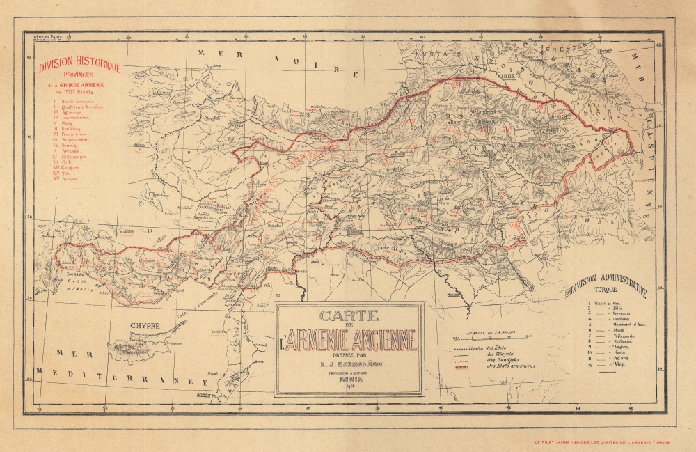
Carte de l'Armenie Ancienne.
1916 (dated) 11.75 x 18 in (29.845 x 45.72 cm) 1 : 4000000
1916 (dated) 11.75 x 18 in (29.845 x 45.72 cm) 1 : 4000000
Description
Published during the Armenian Genocide, this is a 1916 Karapet Basmadjian map of ancient Armenia. An ardent Armenian nationalist, Basmadjian created this piece as part of his never-ending drive for Armenian autonomy and self-determination.
A Closer Look
Depicting ancient Armenia as it appeared in the 7th century, 15 provinces are illustrated stretching from the Gulf of Adalia (Gulf of Antalya) to the Caspian Sea. Armenian cities, towns, and villages are labeled. Turkish states, vilayets (numerically labeled as well), and sandjaks are also delineated, underscoring the reality that ancient Armenia is part of what was then Ottoman Turkey.The Armenian Genocide
Occurring between 1915 and 1917, the Armenian Genocide was the systematic destruction of the Armenian people and identity. This horror took place in the Ottoman Empire and was carried out by the Committee of Union and Progress. Around one million Armenians were marched to the Syrian Desert. Those that survived were forcibly converted to Islam and placed into concentration 'death' camps. Organized intentional killing mostly ended by January 1917, however ethnic cleansing continued after World War I (1914 - 1918) during the Turkish War of Independence (1919 - 1923). As of 2022, only 31 countries have recognized the Armenian Genocide. In 2021, Joe Biden became the first American president to do so.Publication History and Census
This map was created and published in 1916 in Paris by Karapet Basmadjian. We note three examples cataloged in OCLC which are part of the collections at the Muséum national d'histoire naturelle in Paris, France, the Bibliothèque nationale de France, and the Bibliothèque Diderot in Lyon, France. We are aware of only one other instance when this map appeared on the private market.Cartographer
Karapet J. Basmadjian (1864 - 1942) (Կարապետ Բասմաջեան) was an Armenian polymath, historian, numismatist, pharmacist, and archaeologist. Born in Constantinople, it appears Basmadjian was living in Venice in 1897 where he published his book Inscriptions cuneiforms vanniques de Manazgert and was in Paris by 1902, where he founded the journal Banasēr (Բանասէր) and spent the rest of his life. He published four maps: Carte de l'Arménie ancienne (1916), Carte de Cilicie et ses Environs (1918), Arménie Revendications Arméniennes (1919), and Carte ethnographique de l'Arménie (1919). Basmadjian was an outspoken advocate for Armenian independence (which is probably why he was exiled from Constantinople). During World War I, when an independent Armenian state became a real possibility, Basmadjian energetically advocated for this cause, along with other Paris-based Armenian intellectuals. It is likely that the two earlier maps (Carte de l'Arménie ancienne and Carte de Cilicie et ses Environs) were part of this movement. The later work, particularly Arménie Revendications Arméniennes, likely celebrated the establishment of the of the First Republic of Armenia (1918 - 1920), illustrated its broadest territorial claims, and advocated for the Republic in the months before the 1920 Treaty of Sèvres. Following the Republic's dissolution after an invasion by Turkish forces and its partition between Turkey and the Russian SFSR, Basmadjian continued to advocate for Armenian self-determination for the rest of his life. Basmadjian's name has been transliterated into Western languages in several different forms, making researching his biography more difficult. Among the alternative spellings are 'Garabed Basmadjian' and 'K. Y. Basmadjian'. More by this mapmaker...
Condition
Good. Toning and soiling.
References
OCLC 870999631.