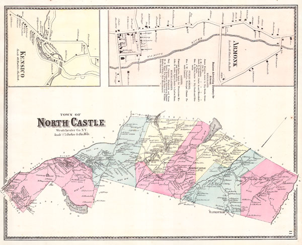
1867 Warner and Beers Map of North Castle and Armonk, Westchester, New York
Armonk-beers-1867$200.00

Title
Town of North Castle Westchester Co. N.Y.
1867 13 x 16 in (33.02 x 40.64 cm)
1867 13 x 16 in (33.02 x 40.64 cm)
Description
This scarce hand colored map is a lithographic engraving of North Castle, Westchester, New York. Map depicts the Westchester cities and town surrounding Armonk, North Castle, Banksville, and Kensico. The extraordinary detail of this map, down to individual households with family names, make it a fascinating study for the family researcher or historian. There are inset maps depicting Armonk and Kensico in even greater detail. Also includes other important information such as the Primary Merchants in Armonk, including the names of the town Carpenter, Blacksmith and Horse Tamer!
Cartographer
The Beers family (Fredrick, Silas, James and Daniel) (fl. c. 1850 - 1886), along with Charles and Augustus Warner, were prominent map publishers working from the 1850s to the late 1880s. Often publishing under the Warner & Beers designation, the combined firms produced a series of important state and county atlases and map of much of the northeastern United States. Many of their regional maps are among the most detailed and well laid out maps ever produced of their respective regions. Because Warner & Beers county maps were often detailed down to the individual homes and landowners, they have become highly sought after by general and family historians. In additional to producing maps of surpassing detail, Warner & Beers also maintained an earlier generation's attention to detail and quality while publishing in an era ever increasingly dominated by the low cost printing methods used by the publishing empires of Rand McNally and George Cram. More by this mapmaker...
Condition
Fine or perfect condition. Wide clean margins. Blank on verso.