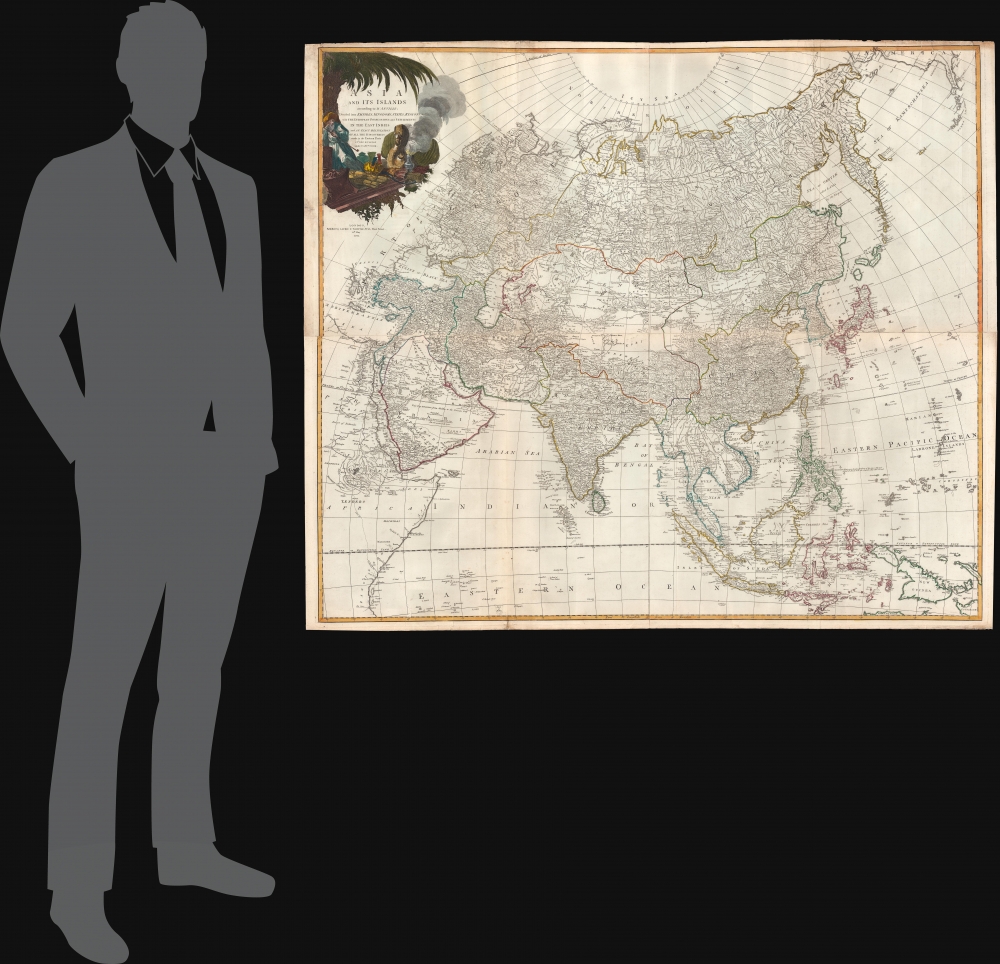
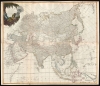
1794 Laurie and Whittle Wall Map of Asia
Asia-lauriewhittle-1794-2$1,800.00


Title
Asia and its Islands According to d'Anville; Divided into Empires, Kingdoms, States, Regions, and ca. with the European possessions and settlements in the East Indies and an exact delineation of all the discoveries made in the eastern parts by the English under Capt. Cook.
1794 (dated) 42 x 48 in (106.68 x 121.92 cm) 1 : 11100000
1794 (dated) 42 x 48 in (106.68 x 121.92 cm) 1 : 11100000
Description
A monumental 1794 wall map of Asia by Laurie and Whittle. The map covers the entire continent of Asia, including Arabia, the Indian subcontinent, and the East Indies. Laurie and Whittle derived their basic cartography from the work of French mapmaker Jean Baptiste Bourguignon d'Anville. Countless cities, caravan routes, and geographical features such as islands, undersea shoals, oases, lakes, rivers, and mountains are identified throughout. In Siberia and East Asia, the mappings of Cook, Bering (including Behring Island, where he died) and Tschirikow are much in evidence. The cartographer has provided copious fascinating notes and annotations in all areas of this incredible work.
Historical Detail
This map is exceptionally interesting for its detailed work in Central Asia - a little-known and largely unmapped region at the time. The cartographer attempts to notate various historical sites. For example, in the Gobi Desert, he identifies, albeit speculatively, the site of Karakarian or Karakorum, the ancient capital of the Mongol Empire, stating 'Hereabout stood the City of Karakarin or Holin, the ancient Seat of the Monguls Empire'. In a similar vein, he also identifies the ruins of various temples and palaces in Tartary.Southeast Asia
Southeast Asia and the East India Islands are mapped after earlier Dutch maps with only speculative commentary on the interior. Kingdoms of Pegu (Burma), Siam (Thailand), Tonkin and Chochin (Vietnam), and Camboja (Cambodia) are named. Further south, the Straits of Malacca are noted, as are the Straits of Singapore. Singapore Island, though not identified, is recognizable.Sear of Korea
Korea or Corea is present, if misshapen, in roughly the correct location. The sea between Japan and Korea, whose name, the 'Sea of Korea', 'East Sea', or the 'Sea of Japan,' is here identified in favor of Korea (Gulf of Corea). Historically, Korea has used the term 'East Sea' since 59 B.C., and many books published before the Japanese annexed Korea make references to the 'East Sea' or 'Sea of Korea'. Over time, neighboring and western countries have identified Korea's East Sea using various terms. The St. Petersburg Academy of Sciences referred to the East Sea as 'Koreiskoe Mope' or 'Sea of Korea' in their 1745 map of Asia. Other 17th and 18th century Russian maps alternate between 'Sea of Korea' and 'Eastern Ocean'. The 18th century Russian and French explorers Adam Johan von Krusenstern and La Perouse called it the 'Sea of Japan', a term that became popular worldwide. Nonetheless, the last official Russian map names the East Sea, 'Sea of Korea'. The name is currently still a matter of historical and nationalistic dispute between several countries.Cartouche Detail
An elaborate allegorical title cartouche in the upper left depicts a bearded, possibly Ottoman, trader with his goods, an incense burner, and a camel beneath a palm tree - the whole evocative of the mystique of the orient.Publication History and Census
This map was printed on four sheets, which were then joined. Published by Laurie and Whittle as plate nos. 26-27 in the 1797 edition of Thomas Kitchin's General Atlas.CartographerS
Laurie and Whittle (fl. 1794 - 1858) were London, England, based map and atlas publishers active in the late 18th and early 19th century. Generally considered to be the successors to the Robert Sayer firm, Laurie and Whittle was founded by Robert Laurie (c. 1755 - 1836) and James Whittle (1757-1818). Robert Laurie was a skilled mezzotint engraver and is known to have worked with Robert Sayer on numerous projects. James Whittle was a well-known London socialite and print seller whose Fleet Street shop was a popular haunt for intellectual luminaries. The partnership began taking over the general management of Sayer's firm around 1787; however, they did not alter the Sayer imprint until after Sayer's death in 1794. Apparently Laurie did most of the work in managing the firm and hence his name appeared first in the "Laurie and Whittle" imprint. Together Laurie and Whittle published numerous maps and atlases, often bringing in other important cartographers of the day, including Kitchin, Faden, Jefferys and others to update and modify their existing Sayer plates. Robert Laurie retired in 1812, leaving the day to day management of the firm to his son, Richard Holmes Laurie (1777 - 1858). Under R. H. Laurie and James Whittle, the firm renamed itself "Whittle and Laurie". Whittle himself died six years later in 1818, and thereafter the firm continued under the imprint of "R. H. Laurie". After R. H. Laurie's death the publishing house and its printing stock came under control of Alexander George Findlay, who had long been associated with Laurie and Whittle. Since, Laurie and Whittle has passed through numerous permeations, with part of the firm still extant as an English publisher of maritime or nautical charts, 'Imray, Laurie, Norie and Wilson Ltd.' The firm remains the oldest surviving chart publisher in Europe. More by this mapmaker...
Jean Baptiste Bourguignon d'Anville (1697 - 1782) was perhaps the most important and prolific cartographer of the 18th century. D'Anville's passion for cartography manifested during his school years when he amused himself by composing maps for Latin texts. There is a preserved manuscript dating to 1712, Graecia Vetus, which may be his earliest surviving map - he was only 15 when he drew it. He would retain an interest in the cartography of antiquity throughout his long career and published numerous atlases to focusing on the ancient world. At twenty-two D'Anville, sponsored by the Duke of Orleans, was appointed Geographer to the King of France. As both a cartographer and a geographer, he instituted a reform in the general practice of cartography. Unlike most period cartographers, D'Anville did not rely exclusively on earlier maps to inform his work, rather he based his maps on intense study and research. His maps were thus the most accurate and comprehensive of his period - truly the first modern maps. Thomas Basset and Philip Porter write: "It was because of D'Anville's resolve to depict only those features which could be proven to be true that his maps are often said to represent a scientific reformation in cartography." (The Journal of African History, Vol. 32, No. 3 (1991), pp. 367-413). In 1754, when D'Anville turned 57 and had reached the height of his career, he was elected to the Academie des Inscriptions. Later, at 76, following the death of Philippe Buache, D'Anville was appointed to both of the coveted positions Buache held: Premier Geographe du Roi, and Adjoint-Geographer of the Academie des Sciences. During his long career D'Anville published some 211 maps as well as 78 treatises on geography. D'Anville's vast reference library, consisting of over 9000 volumes, was acquired by the French government in 1779 and became the basis of the Depot Geographique - though D'Anville retained physical possession his death in 1782. Remarkably almost all of D'Anville's maps were produced by his own hand. His published maps, most of which were engraved by Guillaume de la Haye, are known to be near exact reproductions of D'Anville' manuscripts. The borders as well as the decorative cartouche work present on many of his maps were produced by his brother Hubert-Francois Bourguignon Gravelot. The work of D'Anville thus marked a transitional point in the history of cartography and opened the way to the maps of English cartographers Cary, Thomson and Pinkerton in the early 19th century. Learn More...
Thomas Kitchin (August 4, 1718 – June 23, 1784) was a London based engraver, cartographer, and publisher. He was born in London to a hat-dyer of the same name. At 14, Kitchin apprenticed under Emanuel Bowen, under whom he mastered the art of engraving. He married Bowen daughter, Sarah Bowen, and later inherited much of his preceptor's prosperous business. Their son, Thomas Bowen Kitchin, also an engraver joined the family business, which thereafter published in Thomas Kitchin and Son. From 1858 or so Kitchin was the engraver to the Duke of York, and from about 1773 acquired the title, 'Royal Hydrographer to King George III.' He is responsible for numerous maps published in the The Star, Gentleman's Magazine, and London Magazine, as well as partnering with, at various times, with Thomas Jefferys, Emmanuel Bowen, Thomas Hinton, Issac Tayor, Andrew Dury, John Rocque, Louis de la Rochette, and Alexander Hogg, among others. Kitchin passed his business on to his son, Thomas Bowen Kitchin, who continued to republish many of his maps well after his death. Kitchin's apprentices included George Rollos, Bryant Lodge, Thomas Bowen Kitchin, Samuel Turner Sparrow, John Page, and Francis Vivares. Learn More...
Condition
Very good condition. Original folds. Minor offsetting. Original platemark visible. Wide clean margins. Four sheets joined.
References
Rumsey 0411.028, 0411.029, 0411.030. Phillips (Atlases) 4300-26-27, 699. OCLC 7160203. Shirley, R., Maps in the atlases of the British Library, T.LAU-1c (1799 ed.). National Maritime Museum, 375 (3rd ed. 1801).