This item has been sold, but you can get on the Waitlist to be notified if another example becomes available, or purchase a digital scan.
1851 Tallis / Rapkin Map of Asia
Asia-tallis-1851$125.00

Title
Asia.
1851 (undated) 10.5 x 13.5 in (26.67 x 34.29 cm) 1 : 52000000
1851 (undated) 10.5 x 13.5 in (26.67 x 34.29 cm) 1 : 52000000
Description
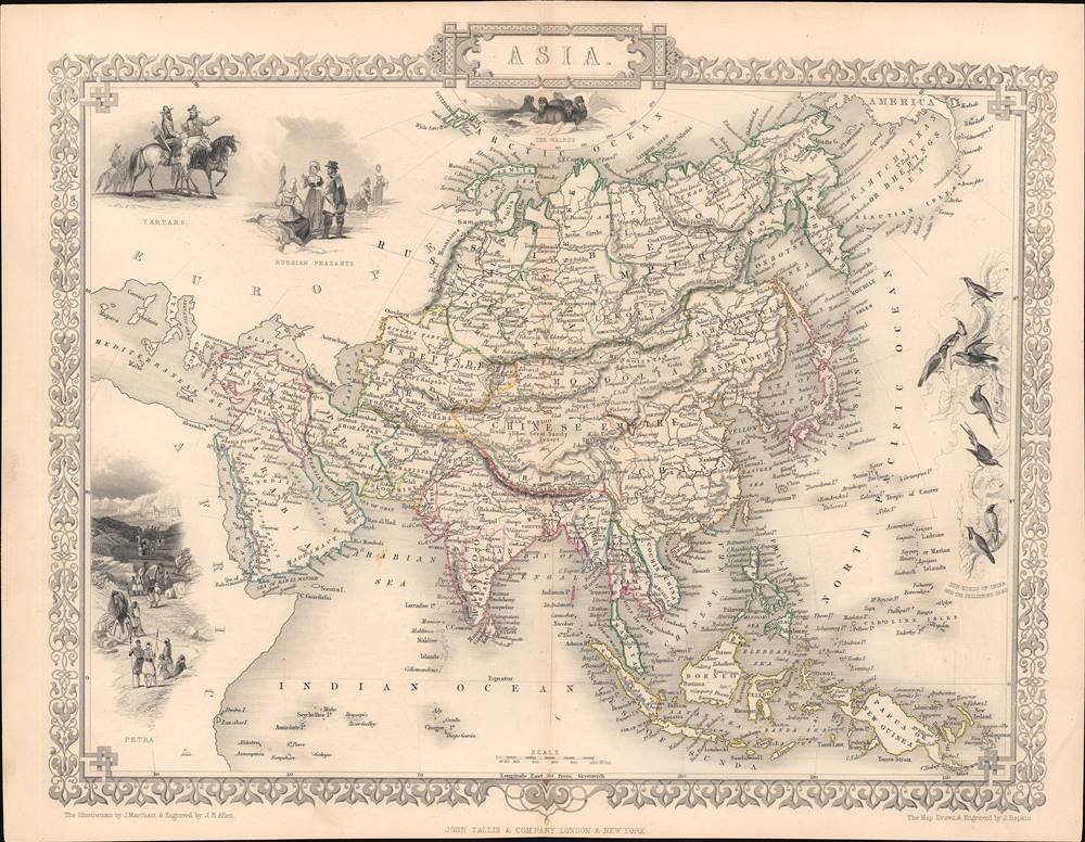
This is a rare and beautifully illustrated 1851 map of Asia by John Rapkin that appeared in Tallis's Illustrated Atlas and Modern History of the World. It shows Asia on the eve of rapid European imperial expansion, which would soon bring much of the territory shown here under direct or indirect control.
At the same time, it shows that nomenclature, spelling, and the exact geography of some areas was still a work in progress, in part as a result of territorial changes at the frontiers of empires. For instance, Ladakh (Ladak) is shown as part of the lands of the Qing (Chinese Empire), perhaps because it had been invaded and partially subordinated by Tibet in the 17th century, but by the time this map was made it had been annexed by the Princely State of Jammu and Kashmir and then fallen under British suzerainty.
European imperial expansion in the following decades would incorporate much of the territory on this map. The lands marked as 'Independent Tartary' here would all be conquered by the Russian Empire by the end of the century, while the ailing Qing Dynasty would attempt to more firmly control their portion of Central Asia after reconquering it from rebels in the 1870s and the establishment of Xinjiang Province in 1884.
The northern part of Manchuria is called Saghalien Oula, a Manchu term that was likely a holdover from the influential 18th century map of China by Jean-Baptiste Bourguignon d'Anville. Between 1858 and 1860, much of this territory would be forcibly ceded to the Russian Empire in the Amur Annexation (Treaty of Aigun and Convention of Beijing).
As was standard for the time, the lands of the Nguyen Dynasty are referred to as Cochin China while the soon-to-be-established (1862) French territory of that name only included the southernmost portion of present-day Vietnam.
Illustrated vignettes surround the map, including a depiction of Petra in present-day Jordan, Tartars (a generic term for Central Asians and nomads in other nearby regions) and Russian peasants at top-left, walruses at top-center, and sun-birds of India and the Philippine Islands at right.
A Closer Look at the Map
This map follows a conventional definition of Asia as the lands east of the Ural Mountains, the Bosporus, and the Suez. Given the popularity of Tallis's Atlas, it both contributed to and reflected the growing familiarization of the British public with far distant lands.At the same time, it shows that nomenclature, spelling, and the exact geography of some areas was still a work in progress, in part as a result of territorial changes at the frontiers of empires. For instance, Ladakh (Ladak) is shown as part of the lands of the Qing (Chinese Empire), perhaps because it had been invaded and partially subordinated by Tibet in the 17th century, but by the time this map was made it had been annexed by the Princely State of Jammu and Kashmir and then fallen under British suzerainty.
European imperial expansion in the following decades would incorporate much of the territory on this map. The lands marked as 'Independent Tartary' here would all be conquered by the Russian Empire by the end of the century, while the ailing Qing Dynasty would attempt to more firmly control their portion of Central Asia after reconquering it from rebels in the 1870s and the establishment of Xinjiang Province in 1884.
The northern part of Manchuria is called Saghalien Oula, a Manchu term that was likely a holdover from the influential 18th century map of China by Jean-Baptiste Bourguignon d'Anville. Between 1858 and 1860, much of this territory would be forcibly ceded to the Russian Empire in the Amur Annexation (Treaty of Aigun and Convention of Beijing).
As was standard for the time, the lands of the Nguyen Dynasty are referred to as Cochin China while the soon-to-be-established (1862) French territory of that name only included the southernmost portion of present-day Vietnam.
Illustrated vignettes surround the map, including a depiction of Petra in present-day Jordan, Tartars (a generic term for Central Asians and nomads in other nearby regions) and Russian peasants at top-left, walruses at top-center, and sun-birds of India and the Philippine Islands at right.
Publication History and Census
This map was part of Tallis's Illustrated Atlas and Modern History of the World and was most likely published in 1851. It was drawn and engraved by John Rapkin and the vignette illustrations were drawn by J. Marchant and engraved by J.B. Allen. It is held by a number of libraries in North America, Great Britain, and in former territories of the British Empire (Australia, Singapore).CartographerS
John Rapkin (July 18, 1813 - June 20, 1899) was an English mapmaker and engraver. Born in Southwark, Rapkin was the son of George Rapkin, a shoemaker, and his wife Elizabeth Harfy. Rapkin and his brother Richard both became engravers and his other brother, William Harfy Rapkin, became a copperplate printer. Rapkin produced works for James Wyld and John Tallis, including The United States and the relative position of Oregon and Texas for Wyld around 1845, and a series of eighty maps for Tallis that became 'Tallis's illustrated atlas, and modern history of the world' in 1851. Rapkin married Frances Wilmot Rudell on January 4, 1837, with whom he had at least eight children, some of whom became engravers, including his sons John Benjamin Rapkin (1837 - 1914), Alfred Thomas Rapkin (1841 - 1905), Joseph Clarke Rapkin (1846? - 1912), and Frederick William Rapkin (1859 - 1945). Rapkin operated under the imprint 'John Rapkin and Sons from 1867 until 1883, and was operating as 'John Rapkin and Sons' by 1887. Rapkin died in 1899 at the age of 85 soon after the death of his wife of over sixty years. More by this mapmaker...
John Tallis and Company (1838 - 1851) published views, maps, and atlases in London from roughly 1838 to 1851. Their principal works, expanding upon the earlier maps of John Cary and Aaron Arrowsmith, include an 1838 collection of London Street Views and the 1849 Illustrated Atlas of the World. The firm’s primary engraver was John Rapkin, whose name and decorative vignettes appear on most Tallis maps. Due to the embellishments typical of Rapkin's work, many regard Tallis maps as the last bastion of English decorative cartography in the 19th century. Although most Tallis maps were originally issued uncolored, it was not uncommon for 19th century libraries to commission colorists to "complete" the atlas. The London Printing and Publishing Company of London and New York bought the rights for many Tallis maps in 1850 and continued issuing his Illustrated Atlas of the World until the mid-1850s. Specific Tallis maps later appeared in innumerable mid to late-19th century publications as illustrations and appendices. Learn More...
John Tallis (November 7, 1817 - June 3, 1876) was an English map publisher and bookseller. Born in Stourbridge in Worcestershire, worked in his father's Birmingham agency from 1836 until 1842. Roughly in 1838, Tallis published a collection of London Street Views, and entered into a partnership with his brother Frederick Tallis from 1842 - 1849. Tallis and Company also published the Illustrated Atlas of the World in 1849. Also in 1849, Tallis traveled to New York City where he founded publishing agencies in six American cities. Upon returning from New York, Tallis paid his brother £10,000 for his share of the business, and operated from then on as John Tallis and Company until 1854. By 1853, John Tallis and Company had agencies in twenty-six cities in the United Kingdom, the United States, and Canada and employed over 500 people. By the end of 1853, Tallis had made the decision to share the burden of running such an extensive company and formed the London Printing and Publishing Company on February 24, 1854, becoming co-managing director with Ephraim Tipton Brain. After a series of setbacks, however, Tallis had to sell his estate and by 1861 was declared bankrupt. He was kept afloat by the kindness of friends and former employees, but none of his 'various ambitious projects' ever worked out for the rest of his life. Tallis married Jane Ball on December 6, 1836 in Birmingham, with whom he lived until her death in 1862. Tallis remarried on June 27, 1863 to Mary Stephens, with whom he had two children. Learn More...
James Baylis Allen (1803 - 1876) was a British engraver who trained under his older brother, Josiah Allen, who was also an engraver, as well as the painters John Vincent Barber and Samuel Lines. Allen was especially known for his engravings of landscapes, producing a well-known series on the rivers of France and a number of other series dealing with British, Italian, and Greek landscapes, as well as battle scenes. Many of his engravings appeared in The Art Journal, the premier art journal in 19th century Britain. Learn More...
J Marchant (fl. c. 1825 - 1869) was a British illustrator and cartographer whose most prominent work was in the variosu editions of Tallis's Illustrated Atlas and Modern History of the World. Learn More...
Source
Tallis, J., The Illustrated Atlas, And Modern History Of The World Geographical, Political, Commercial and Statistical, (London and New York: Tallis) 1851.
Condition
Very good. Original fold line visible at center.
References
Rumsey 0466.031. OCLC 50415429.