This item has been sold, but you can get on the Waitlist to be notified if another example becomes available, or purchase a digital scan.
1657 Visscher Map of Asia and the East Indies
Asia-visscher-1657$650.00

Title
Asiae Nova Delineatio Auctore N. Visscher.
1657 (undated) 16.75 x 21 in (42.545 x 53.34 cm) 1 : 19000000
1657 (undated) 16.75 x 21 in (42.545 x 53.34 cm) 1 : 19000000
Description
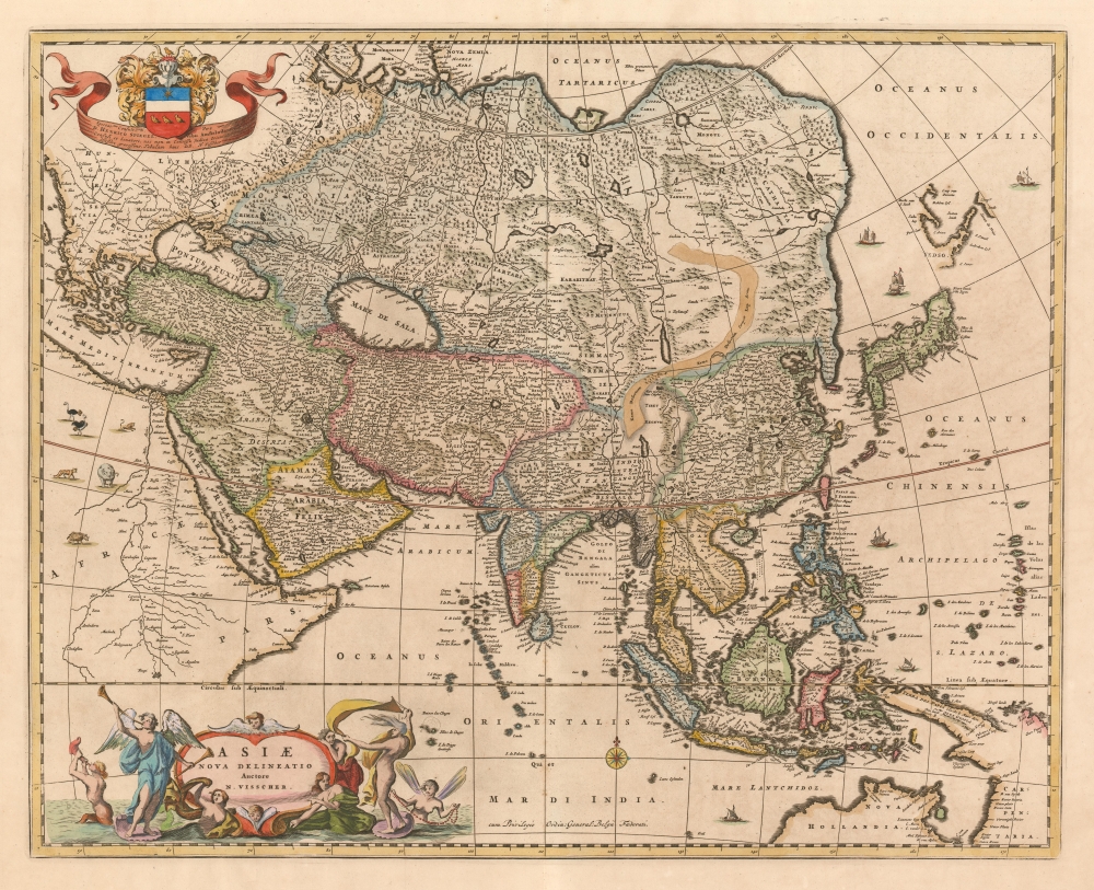
This is Nicolas Visscher's c. 1657 map of Asia, presenting an updated view of Pacific coast of the continent. The Visscher family generally employed larger plates and finer detail than the mapmakers of the first half of the 17th century, improving the clarity of the maps and allowing the addition of more geographical detail. The northern coast of Australia (Nova Hollandia on the map) and the coastline of New Guinea reflect the 1643 and 1644 voyages of Abel Tasman.
Korea appears with minimal detail, but correctly indicated as a peninsula rather than the insular depiction common on maps from the late 16th and early 17th century.
A Glimpse of Hokkaido
Japan and Hokkaido (Yedso) are mapped according to the 1643 discoveries of Dutchmen Maerten de Vries and Cornelis Jansz Coen. Vries and Coen were in search of gold and silver islands supposedly discovered early by a mysterious Spanish or Portuguese navigator, Juan de Gama. They sailed up the east coast of Japan and continued northward into the bay separating Honshū from Hokkaido. They skirted the east coast of this bay before discovering Kunashir, here Staten Land, the most westerly of the Japanese Kuril Island. They also sighted Iturup or Etorofu, the second Kuril Island. This island they only tenuously explored and named Compagnie, after the VOC, their sponsors. Subsequent maps assigned great mass to Compagnie on little more than speculation. These islands were not more properly mapped until the explorations of Vitus Behring.Korea appears with minimal detail, but correctly indicated as a peninsula rather than the insular depiction common on maps from the late 16th and early 17th century.
Chiamay
The apocryphal Lake of Chiamay appears just north of the Bay of Bengal as the source of four important Southeast Asian River systems including the Irrawaddy, the Dharla, the Chao Phraya, and the Brahmaputra. The curious Lake of Chiamay (also called Chiam-may or Chian-may), roughly located in the area of Assam but sometimes as far north as Tibet and China, began to appear in maps of this region as early as the 16th century and persisted well into the mid 18th century. Its origins are unknown but may originate in a lost 16th century geography prepared by the Portuguese scholar Jao de Barros. It was speculated to be the source of five important Southeast Asian River systems and was mentioned in the journals of Sven Hedin. There are even records that the King of Siam led an invasionary force to take control of the lake in the 16th century. Nonetheless, the theory of Lake Chiamay was ultimately disproved, and it disappeared from maps entirely by the 1760s.A Superb Engraving
It is a beautifully decorative map. Six ships sail along the coasts. The part of the map occupied by Africa is embellished with ostriches, lions, an elephant, and a rhinoceros. The map's lively cartouche depicts a festive (deafening?) scene: To the left, an angel and an ichthyocentaur blow upon horns. The sea-centaur has a conch; the angel's instrument resembles a vuvuzela. To the right of the cartouche a windy, naked male figure, perhaps Aeolus, performs a sort of dance-of-the-seven-veils with what appear to be sails. A pair of mermaids and a fairy look on, impressed. In the upper left, an elegant cartouche dedicates the map to the Hendrik Dirksen Spiegel (1598 - 1667), an Amsterdam Mayor, consul, and assessor of the East India Company.Publication History and Census
This map appears to have first been included in Jansson's Novus Atlas (1657 - 1658), and was later included with Visscher's Atlas Contractus. The presence of the 'Cum Priviligeo' indicates a date no earlier than 1677, and that the map was probably included by one of the younger Visschers in their Atlas Minor, the composite atlas published by the family starting in the mid-1670 and continuing without change into the 18th century. Fifteen examples of the Atlas Minor appear in OCLC with varying pagination. The separate map is well represented in institutional collections.Cartographer
Claes Jansz Visscher (1587 - 1652) established the Visscher family publishing firm, which were prominent Dutch map publishers for nearly a century. The Visscher cartographic story beings with Claes Jansz Visscher who established the firm in Amsterdam near the offices of Pieter van den Keer and Jadocus Hondius. Many hypothesize that Visscher may have been one of Hondius's pupils and, under examination, this seems logical. The first Visscher maps appear around 1620 and include numerous individual maps as well as an atlas compiled of maps by various cartographers including Visscher himself. Upon the death of Claes, the firm fell into the hands of his son Nicholas Visscher I (1618 - 1679), who in 1677 received a privilege to publish from the States of Holland and West Friesland. The firm would in turn be passed on to his son, Nicholas Visscher II (1649 - 1702). Visscher II applied for his own privilege, receiving it in 1682. Most of the maps bearing the Visscher imprint were produced by these two men. Many Visscher maps also bear the imprint Piscator (a Latinized version of Visscher) and often feature the image of an elderly fisherman - an allusion to the family name. Upon the death of Nicholas Visscher II, the business was carried on by the widowed Elizabeth Verseyl Visscher (16?? - 1726). After her death, the firm and all of its plates was liquidated to Peter Schenk. More by this mapmaker...
Source
Visscher, Nicolas II, Atlas Minor, (Amsterdam) c. 1677.
Condition
Very good condition. Mend to bottom centerfold not affecting image. A bright, attractive example.
References
OCLC 159840968. Rumsey 11755.108. Koeman Vis 19, P. 169-170