This item has been sold, but you can get on the Waitlist to be notified if another example becomes available, or purchase a digital scan.
1794 Wilkinson Map of Asia and Australia
Asia-wilkinson-1794$75.00

Title
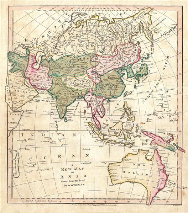
A New Map of Asia drawn from the latest Discoveries.
1794 (dated) 10.5 x 8.5 in (26.67 x 21.59 cm)
1794 (dated) 10.5 x 8.5 in (26.67 x 21.59 cm)
Description
A finely detailed first edition 1794 map of Asia and Australia by Robert Wilkinson. Wilkinson's map covers from the Russian Arctic to the Indian Ocean and from Madagascar to New South Wales and New Guinea.
Here Asia is divided into various geographical and political zones, including Arabia, Hindoostan (India), Southeast Asia, China, Persia, and Tibet, and the Tartaries. Though much of Central Asia was, for all intent and purposes, unknown to europeans of the late 18th century, Wilkinson derives his boundaries from antiquated histories relating to the breakup of the Mongol empire. These follow the a model that would soon be codified by John Winterbotham in his 1795 treatise A Historical, Geographical and Philosophical View of the Chinese empire which includes Tibet as part of eastern Tartary – those non-Chinese states to the west and east of the China proper owing, to varying degrees, allegiance to China. Winterbotham drew his distinctions from some of the old borders created following the breakup of the Mongol empire. Under Kublai Kahn, who ruled from China as a mostly Chinese emperor, Tibet was, though not China, clearly under Chinese vs. Central Asian Mongol control. In 1792, just two years before this map was issued, the Qing emperor sent a vast Chinese army into Tibet to discourage Nepali incursions into the region.
To the south, Australia is identified as New Holland, with the english colonies along the east coast, established in 1788, being identified with red color coding as NewSouth Wales. Tasmania, or Van Dieman's Land, is clearly attached to the mainland. It would not be until 1798, four years after Wilkinson drew this map, that Matthew Flinders and George Bass would prove conclusively Tasmania's insularity.
The disputed sea between Japan and Korea is here labeled the 'Gulf of Korea.' Some early maps identify this sea as the 'Sea of Japan' and the two nations have consequently been disputing the 'official' name ever since. engraved by Thomas Condar for the 1794 first edition of Robert Wilkinson's General Atlas.
CartographerS
Robert Wilkinson (fl. c. 1758 - 1825) was a London based map and atlas publisher active in the late 18th and early 19th centuries. Most of Wilkinson's maps were derived from the earlier work of John Bowles, one of the preeminent English map publishers of the 18th century. Wilkinson's acquired the Bowles map plate library following that cartographer's death in 1779. Wilkinson updated and retooled the Bowles plates over several years until, in 1794, he issued his first fully original atlas, The General Atlas of the World. This popular atlas was profitably reissued in numerous editions until about 1825 when Wilkinson died. In the course of his nearly 45 years in the map and print trade, Wilkinson issued also published numerous independently issued large format wall, case, and folding maps. Wilkinson's core cartographic corpus includes Bowen and Kitchin's Large English Atlas (1785), Speer's West Indies (1796), Atlas Classica (1797), and the General Atlas of the World (1794, 1802, and 1809), as well as independent issue maps of New Holland (1820), and North America ( 1823). Wilkinson's offices were based at no. 58 Cornhill, London form 1792 to 1816, following which he relocated to 125 Frenchurch Street, also in London, where he remained until 1823. Following his 1825 death, Wilkinson's business and map plates were acquired by William Darton, an innovative map publisher who reissued the General Atlas with his own imprint well into the 19th century. More by this mapmaker...
Thomas Conder (1747 - June 1831) was an English map engraver and bookseller active in London during the late 17th and early 18th centuries. From his shop at 30 Bucklersbury, London, Conder produced a large corpus of maps and charts, usually in conjunction with other publishers of his day, including Wilkinson, Moore, Kitchin, and Walpole. Unfortunately few biographical facts regarding Conder's life have survived. Thomas Conder was succeeded by his son Josiah Conder who, despite being severely blinded by smallpox, followed in his father's footsteps as a bookseller and author of some renown. Learn More...
Source
Wilkinson, R., A General Atlas being A Collection of Maps of the World and Quarters the Principal Empires, Kingdoms, and C. with their several Provinces, and other Subdivisions Correctly Delineated., (London) 1794 First Edition.
Condition
Very good. Minor marginal soiling. Original platemark visible. Blank on verso.