This item has been sold, but you can get on the Waitlist to be notified if another example becomes available, or purchase a digital scan.
1898 Matthews Northrup Railroad Map of the Eastern United States
AtlanticCoastLine-matthewsnorthrup-1898$1,600.00

Title
Atlantic Coast Line via Washington and Richmond The Short Line.
1898 (undated) 33.75 x 19 in (85.725 x 48.26 cm) 1 : 4000000
1898 (undated) 33.75 x 19 in (85.725 x 48.26 cm) 1 : 4000000
Description
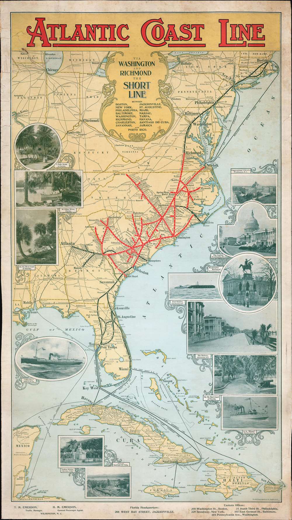
An outstanding c. 1898 Matthews-Northrup railroad broadside map of the eastern United States. Depicting the region from Boston to Jamaica and from St. Louis and New Orleans to the Atlantic Ocean, major railway lines throughout the country are illustrated and labeled, along with steamship lines between Florida and Cuba, Puerto Rico, and Jamaica. Thick red lines highlight the route of the Atlantic Coast Line, with white dots marking every station stop. Much less detailed thick black lines illustrate important connecting railroads, including the Plant System from Charleston to Tampa and the Florida East Coast Railway from St. Augustine to Miami. The rest of the extensive rail network in the eastern U.S. is traced by thin black lines bearing the names of their respective railroads. Photographs adorn the left and right borders and promote Florida's mild climate and the history of the American South to a Northern audience.
The Atlantic Coast Line
The name Atlantic Coast Line first appears in 1871, when the Wilmington and Weldon Railroad and the Wilmington and Manchester Railroad began using the name to promote their two rail lines mutually. A Baltimore-based investor, William T. Walters, acquired these two railroads after the American Civil War and operated them as two separate railroads. Most of Walter's South Carolina railroads were consolidated in 1897-1898 and became known as the Atlantic Coast Line Railroad Company of South Carolina. Railroads in Virginia consolidated in 1898 as well and became the Atlantic Coast Line Railroad Company of Virginia, as did the railroads in North Carolina in 1899. All these lines consolidated in 1899 or 1900 to become the Atlantic Coast Line Railroad Company. The Atlantic Coast Line then acquired the Plant System in 1902.The Plant System
The Plant System was a network of railroads and steamship lines owned by Henry B. Plant. Plant bought the bankrupt Atlantic and Gulf Railroad on November 4, 1879, and reorganized it as the Savannah, Florida, and Western Railway. Over the following twenty-three years, Plant leased, bought, and built railroad lines throughout the southeastern part of the United States and expanded his railroad system. The entire system was acquired by the Atlantic Coast Line Railroad in 1902.Dating the Map: the Miami
A photograph of a steamship printed along the right border depicts the S.S. Miami of the Florida East Coast Steam Ship Company. The Miami was launched from William Cramp and Sons of Philadelphia on October 23, 1897. She was 239.2 feet long and had a gross weight of 1,741 tons. Her first trip between Miami and Nassau left Miami on January 17, 1898, making the earliest possible year that this map could have been printed 1898. That is likely the publication year because company's tended to promote their newest and latest acquisitions.Publication History and Census
This map was created and published by Matthews-Northrup c. 1898. This is the only catalogued surviving example.Cartographer
Matthews-Northrup Works (fl. c. 1895 - 1930) were a Buffalo, New York based, in their own words, "writing, designing, engraving, printing, [and] binding" firm. The firm was founded by James Newson Matthews (November 21, 1828 - December 20, 1888) as the J. N. Matthews Company. William Phelps Northrup (April 2, 1850 - February 2, 1929) later joined the company as an apprentice and then partner, at which point the firm was reincorporated as the Matthews-Northrup Works. The Matthews-Northrup Works rose to prominence as publishers and printers of railroad maps, with dozens to their credit. When James died, his shares were inhered by George Edward Matthews (1855 - 1910), who ran the business until his death in 1910. Also in 1910, they famously redesigned the cover of National Geographic Magazine. Despite some six previous cover changes in just 21 years, the Matthews-Northrup layout proved so popular that it was used for nearly 50 years. The firm can also take credit for the Winchell typeface, designed in 1903 under E. E. Winchell's tenure as art director. Curiously, the partners of Matthews-Northrup maintained an unusual affectation in which only the officers of the company could wear beards or mustaches. In this same spirit, the firm also had its own private social club, the Fellowcraft Club, where the all-male employees could relax, play pool, drink and dine. Matthews-Northrup maintained offices on Washington Street, Buffalo, where they were based, as well as Madison Square, New York City, Garden Tower, Boston, and the Citizens Building in Cleveland. More by this mapmaker...
Condition
Good. Exhibits slight foxing and toning. Mounted poster style on heavy linen.