This item has been sold, but you can get on the Waitlist to be notified if another example becomes available, or purchase a digital scan.
1822 Manuscript Charles Haskell Schoolboy Map of the Atlantic Ocean
AtlanticOceanSchoolboy-haskell-1822$2,250.00

Title
Chart of the Atlantic Ocean.
1822 (dated) 13 x 22.5 in (33.02 x 57.15 cm)
1822 (dated) 13 x 22.5 in (33.02 x 57.15 cm)
Description
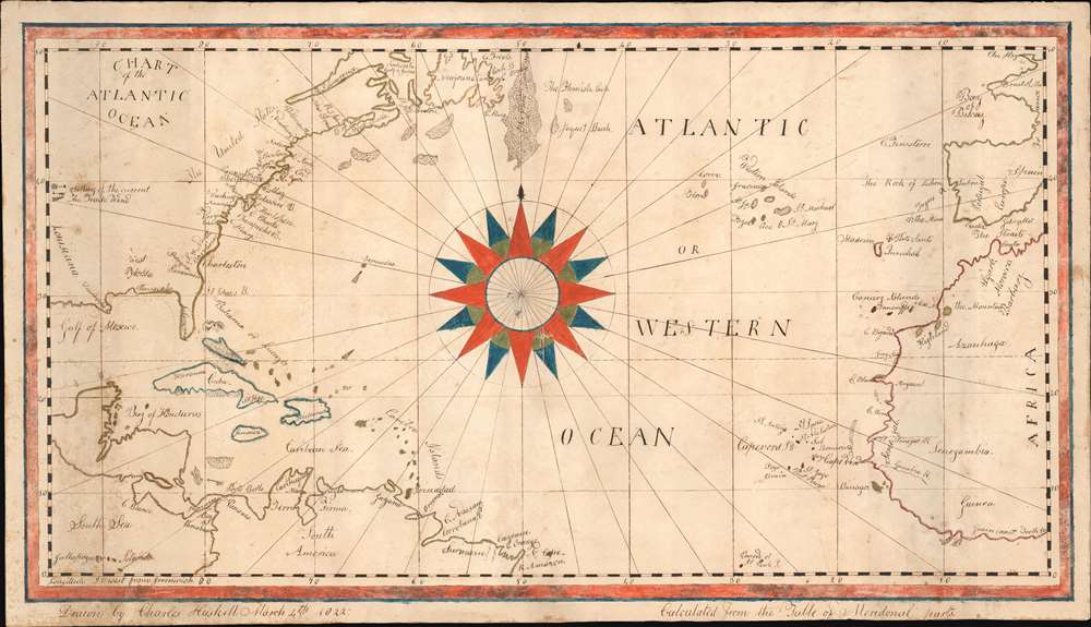
An exceptional and finely executed manuscript school-boy map illustrating the North Atlantic, here called the 'Western Ocean.' A striking compass rose dominates the center of the map. It was executed on March 4, 1822 by Charles Haskell (see below), when he must have been about 14. Despite being young, the map, which is based on Blunt's c. 1820 Chart of the Atlantic Ocean, is finely executed, covering from Louisiana to Gibraltar, incorporating most of the eastern United States, part of South America, and west Africa. As one would suspect of a scion of New England fishermen, the many cod fishing banks off the coast, and the Grand Banks, are illustrated with impressive meticulousness. Curiously, the map includes the Saint Peter and Saint Paul Archipelago, at bottom center, a remote atoll in the Atlantic - rarely visited save by occasional whalers. Haskell also notes prevailing wind and currents.
The Charles Haskell line seems, from this point forward, ill-fated with regard to the sea. Charles Haskell’s son, also Charles (1834 - 1864), died young in Essex, MA, on March 12, 1864. A relative, Samuel Haskell, memorialized him by naming his new schooner, the Charles Haskell. On its second voyage, in March of 1869, the Charles Haskell was caught in a freak storm in the cod fishing grounds at Georges Bank, where it collided and with the Salem ship, Andrew Johnson, nearly cutting it in twain. The Andrew Johnson sank, taking the lives of its entire 26-man crew. The Charles Haskell limped back to port in Cape Ann, where it was repaired and refitted, but thence forth it was known as a 'cursed' ship. Later, in 1870, with a new captain, Clifford Curtis, the ship became notorious for ghostly apparitions that appeared when it sailed on the Georges Bank, apparently the vengeful crew of the Andrew Johnson, desperate take over the ship and return to port. When crew after crew sighted the ghosts, the Charles Haskell was retired as a fishing schooner and never again returned to the Georges Bank, instead finishing its days as a coastal sand freighter.
The Cursed Schooner Charles Haskell
Given where we acquired the map (coastal Maine), and the probable age of the mapmaker in 1822, it is likely that the Charles Haskell in question was born in 1808 in Concord, Hampshire, the scion of a long and prolific line of New England seamen. He was the son of Jeremiah Haskell (1767 - 1844), a native of Newburyport, MA, himself the son of Nehemiah Haskell (1727 -1787), a Gloucester seaman. Charles Haskell died at sea in February of 1858, on a voyage to Somerset, England.The Charles Haskell line seems, from this point forward, ill-fated with regard to the sea. Charles Haskell’s son, also Charles (1834 - 1864), died young in Essex, MA, on March 12, 1864. A relative, Samuel Haskell, memorialized him by naming his new schooner, the Charles Haskell. On its second voyage, in March of 1869, the Charles Haskell was caught in a freak storm in the cod fishing grounds at Georges Bank, where it collided and with the Salem ship, Andrew Johnson, nearly cutting it in twain. The Andrew Johnson sank, taking the lives of its entire 26-man crew. The Charles Haskell limped back to port in Cape Ann, where it was repaired and refitted, but thence forth it was known as a 'cursed' ship. Later, in 1870, with a new captain, Clifford Curtis, the ship became notorious for ghostly apparitions that appeared when it sailed on the Georges Bank, apparently the vengeful crew of the Andrew Johnson, desperate take over the ship and return to port. When crew after crew sighted the ghosts, the Charles Haskell was retired as a fishing schooner and never again returned to the Georges Bank, instead finishing its days as a coastal sand freighter.
Schoolboy / Schoolgirl Maps
The use of mapmaking in teaching is first seen in Europe, mainly England. The Schoolgirl/boy Map became a peculiarly American pedagogical tool in the first part of the 19th Century. Such maps are remarkable for their fine execution, idiosyncratic lettering, and quaint flourishes. They most often illustrate the World, the United States, New England, or specific states. The present example, focusing on the North Atlantic, is most unusual and representative of the wide-ranging nautical character of coastal New England in the early 19th century - and our cartographer's specific family. Most are based on generally available reference maps, such as those found in the atlases produced by Carey and Lea, Finley, and Mitchell. The present map, being nautical in nature, is derived from the chartmaker Blunt. The goals of these exercises were more far-reaching than teaching geography. Students were encouraged to take pains in their draftsmanship, and often achieved beautiful flourishes of artistic expression - as with the compass rose here. But most peculiar to the American iterations of educational mapping was the goal of instilling a sense of civic pride and responsibility. Indeed, the key desired result of education in the post-Revolutionary-War United States was to prepare for the education of the next generation of American citizens, a patriotic duty. For a good overview, see Betty Mason's '19th Century Schoolgirls Were Incredibly Good at Drawing Maps.' Published July 27, 2016 by National Geographic.Publication History and Census
This map was drawn on March 4th, 1822 by Charles Haskell. It is based upon a c. 1820 chart by Edmund March Blunt, also titled Chart of the Atlantic Ocean. As a manuscript, this map is one of a kind.Cartographer
Edmund March Blunt (June 20, 1770 - 1862) was an American navigator, bookseller, chartmaker, and cartographer based in Newburyport, Massachusetts. Blunt was born in Portsmouth, New Hampshire in 1770. In 1796, along with the nominal assistance of prominent navigator Captain Lawrence Furlong, Blunt published The American Coast Pilot, one of the most important published works on American navigation. Although much of the work was plagiarized from British publications, the Coast Pilot was an immediate popular success. In response to the popularity of his work, Blunt published 21 subsequent editions, each with important updates and revisions. The first edition to contain map plates was printed in 1804. Following a fire that destroyed his offices at The Sign of the Bible in 1811, Blunt moved his business to New York and opened a new shop, The Sign of the Quadrant. His sons Edmund Jr. (1799 - 1866) and George William (1802 - 1878), joined the firm in 1824 and eventually took over the family business, renaming the firm 'E. and G. W. Blunt'. They both produced their own nautical books, charts, and instruments, as well as republished their father’s work. In 1830, Edmund accepted a position under Ferdinand Hassler at the United States Office of the Coast Survey. Much of Blunt's original work eventually found its way into U.S. Coast Survey Publications. George closed the firm in 1872 and sold the plates and chart copyrights to the U.S. Coast Survey and the U.S. Navy Hydrographic Office. Due to the quality and detail of Blunt's work, revised editions of his most important charts were republished well into the 1880s. More by this mapmaker...
Condition
Very good. Some spotting and soiling.