This item has been sold, but you can get on the Waitlist to be notified if another example becomes available, or purchase a digital scan.
1852 Cruchley Map of Australia and Polynesia
Australia-cruchley-1853$100.00

Title
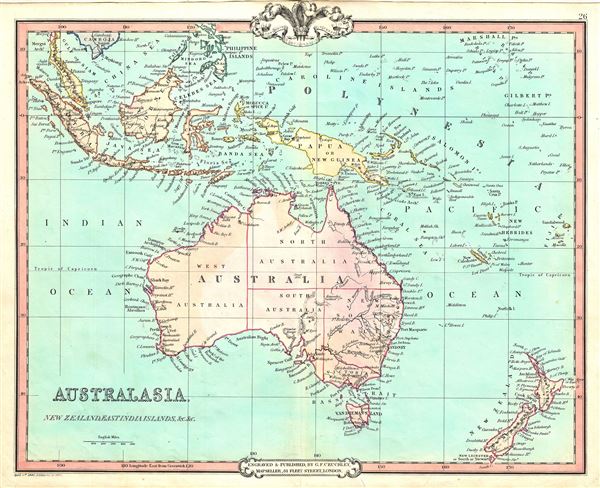
Australasia, New Zealand, East India Islands, etc. etc.
1852 (dated) 15 x 18 in (38.1 x 45.72 cm) 1 : 21000000
1852 (dated) 15 x 18 in (38.1 x 45.72 cm) 1 : 21000000
Description
This is a fine example of George Frederick Cruchley's 1852 map of Australia, New Zealand and the East India Islands. It covers from the Malay Peninsula to New Zealand, including Australia, Malaysia, Indonesia, Philippines, Papua New Guinea and Melanesia. An interesting map issued just as most of the earth's non-polar shore has been explored. Gone are many of the errors of the previous century with the coastlines accurately rendered. Inland though, much remained confused. Vast stretches of unmapped territory and speculative cartography fill central Australia, New Zealand and Papua New Guinea. Regions and territories are color coded with elevation rendered by hachures.
In 1840, after the signing of the Treaty of Waitangi, the British annexed New Zealand as part of the Australian colony of New South Wales. However, it separated from New South Wales to become a colony in its own right in 1841. Victoria became an independent colony separate from New South Wales only in July 1851.
Cruchley's General Atlas was unique for its period, employing a vivid color scheme extending even to the oceans, distinctive typography, and various uncommon decorative elements including a peacock feather crown and an imprint medallion, both of which break the printed border. Though many of the maps in this atlas are copyrighted in 1842, the atlas was first published in 1843 from the Cruchley office at 81 Fleet Street, London, and proving popular went through numerous reissues well into the 1850s.
Cartographer
George Frederick Cruchley (April 23, 1797 - June 16, 1880) was a London based book and map seller active in the middle part of the 19th century. Cruchley began his cartographic career as an apprentice at the venerable Aaroon Arrowsmith firm. Many of Cruchley's earliest maps bear the words 'From Arrowsmith's' on the imprint. In 1844, Cruchley acquired the massive stock of the important early 19th century firm of John Cary. Cruchley published his own maps as well as reissues of Cary's stock well into the 1870s. He is best known for his detailed plans of London, which in recent years have become increasingly scarce and desirable. Cruchley was based in London on 38 Ludgate Street until 1834 when he moved his offices to 81 Fleet Street. Shortly before his death in 1880 Cruchely auctioned (Hodgson's Auctions, Jan 16, 1877) his entire stock. Many of his map plates were thusly acquired by 'Gall and Inglis' who continued the Cruchley tradition well into the early 20th century. Cruchley's son, also George Frederick (1837 - 1882), continued to work as a book and map seller until his death. More by this mapmaker...
Source
Cruchley, G. F., Cruchley's General Atlas, for the use of Schools and Private Tuition, London, 1853.
Condition
Very good. Minor wear and toning along original centerfold. Blank on verso.